Difference between revisions of "2018-08-25 51 9"
imported>Digiphono (→Photos) |
imported>GeorgDerReisende (expedition report for Niestetal-Heiligenrode) |
||
| Line 1: | Line 1: | ||
| − | |||
| − | |||
| − | |||
| − | |||
| − | |||
| − | |||
| − | |||
| − | |||
| − | |||
| − | |||
{{meetup graticule | {{meetup graticule | ||
| lat=51 | | lat=51 | ||
| Line 23: | Line 13: | ||
== Participants == | == Participants == | ||
| − | + | * [[User:Digiphono|Digiphono]] and his wife | |
| − | + | * [[User:GeorgDerReisende|GeorgDerReisende]] | |
| − | [[User:Digiphono|Digiphono]] and his wife | ||
== Plans == | == Plans == | ||
| + | === Digiphono === | ||
<!-- what were the original plans --> | <!-- what were the original plans --> | ||
My wife never understood the fun I had with geocaching and right now she's even more curious about this geohashing thing I'm telling her about since, well, one and a half weeks... To show her the silliness of geohashing, I will take her some 75 meters off a path into a small wooded area and show her my excitement about reaching random coordinates in the middle of nowhere and my geohash app saying "you're there" - which will be '''very''' hard to understand for her hehe... | My wife never understood the fun I had with geocaching and right now she's even more curious about this geohashing thing I'm telling her about since, well, one and a half weeks... To show her the silliness of geohashing, I will take her some 75 meters off a path into a small wooded area and show her my excitement about reaching random coordinates in the middle of nowhere and my geohash app saying "you're there" - which will be '''very''' hard to understand for her hehe... | ||
To get her attracted to this, I had to promise we'll do some shopping first, so it's hard to say '''when''' we will catch this geohash, but I guess on somewhere between noon and 2 pm (if I'm lucky haha)... | To get her attracted to this, I had to promise we'll do some shopping first, so it's hard to say '''when''' we will catch this geohash, but I guess on somewhere between noon and 2 pm (if I'm lucky haha)... | ||
| + | |||
| + | === GeorgDerReisende === | ||
| + | |||
| + | Because Digiphono didn't tell a time, I made no plans but started at 12:20 from home. | ||
== Expedition == | == Expedition == | ||
| + | === Digiphono === | ||
<!-- how it all turned out. your narrative goes here. --> | <!-- how it all turned out. your narrative goes here. --> | ||
As we woke up this morning, the sky was darkened gray and a pouring rain smacked on the windows of our house... 'So, that means no geohashing today' my wife said and I started to get a little sad of course, since this would mean I had to go shopping without visiting the geohash! | As we woke up this morning, the sky was darkened gray and a pouring rain smacked on the windows of our house... 'So, that means no geohashing today' my wife said and I started to get a little sad of course, since this would mean I had to go shopping without visiting the geohash! | ||
| Line 40: | Line 35: | ||
Guess she still doesn't understand the purpose of geohashing, but luckily she also said it was nice to be out there and this will certainly not be our last geohash together ;-) | Guess she still doesn't understand the purpose of geohashing, but luckily she also said it was nice to be out there and this will certainly not be our last geohash together ;-) | ||
| + | |||
| + | === GeorgDerReisende === | ||
| + | |||
| + | I left home at 12:20, took a tram 6 and a bus 32 and arrived at Heiligenrode at 13:40. From there I walked to the hash. The northern side of the vale looked very steep. So I walked around, may be the upper side would be flat. And it was, the hash was just at the edge to the valley. But I didn't see anybody. BTW Digiphono, do you own a black car? | ||
== Tracklog == | == Tracklog == | ||
| Line 49: | Line 48: | ||
Image:2012-##-## ## ## Alpha.jpg | Witty Comment | Image:2012-##-## ## ## Alpha.jpg | Witty Comment | ||
--> | --> | ||
| + | === Digiphono === | ||
<gallery> | <gallery> | ||
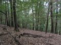
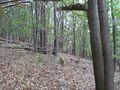
Image:2018_08_25_51_9_001.JPG | The way to the hash | Image:2018_08_25_51_9_001.JPG | The way to the hash | ||
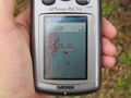
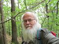
| Line 54: | Line 54: | ||
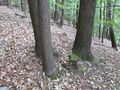
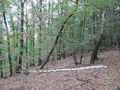
Image:2018_08_25_51_9_003.JPG | The hash - a stone on which a bird was sacrificed | Image:2018_08_25_51_9_003.JPG | The hash - a stone on which a bird was sacrificed | ||
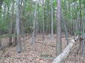
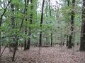
Image:2018_08_25_51_9_004.JPG | The way back from the hash | Image:2018_08_25_51_9_004.JPG | The way back from the hash | ||
| + | </gallery> | ||
| + | === GeorgDerReisende === | ||
| + | <gallery> | ||
| + | Image:2018-08-25 51 9 GeorgDerReisende 0232.jpg | the other side looks steep | ||
| + | Image:2018-08-25 51 9 GeorgDerReisende 0233.jpg | very steep | ||
| + | Image:2018-08-25 51 9 GeorgDerReisende 0238.jpg | at above: looks good | ||
| + | Image:2018-08-25 51 9 GeorgDerReisende 0242.jpg | the area of hash | ||
| + | Image:2018-08-25 51 9 GeorgDerReisende 0245.jpg | the hash is at the three trees at the left | ||
| + | Image:2018-08-25 51 9 GeorgDerReisende 0249.jpg | proof, for a moment I got a 2 | ||
| + | Image:2018-08-25 51 9 GeorgDerReisende 0263.jpg | proof, the pointer danced more than me | ||
| + | Image:2018-08-25 51 9 GeorgDerReisende 0250.jpg | here is my hash | ||
| + | Image:2018-08-25 51 9 GeorgDerReisende 0251.jpg | looking to the north | ||
| + | Image:2018-08-25 51 9 GeorgDerReisende 0252.jpg | the east | ||
| + | Image:2018-08-25 51 9 GeorgDerReisende 0253.jpg | the south | ||
| + | Image:2018-08-25 51 9 GeorgDerReisende 0255.jpg | the west | ||
| + | Image:2018-08-25 51 9 GeorgDerReisende 0256.jpg | GeorgDerReisende | ||
| + | Image:2018-08-25 51 9 GeorgDerReisende 0292.jpg | on the way to a bus stops I was overtaken by this farmer, since then I have a new parfum | ||
</gallery> | </gallery> | ||
Revision as of 16:12, 25 August 2018
| Sat 25 Aug 2018 in 51,9: 51.3123594, 9.5741791 geohashing.info google osm bing/os kml crox |
Location
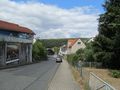
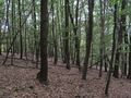
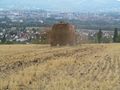
In a small wooded area north of Niestetal / Kassel
Participants
- Digiphono and his wife
- GeorgDerReisende
Plans
Digiphono
My wife never understood the fun I had with geocaching and right now she's even more curious about this geohashing thing I'm telling her about since, well, one and a half weeks... To show her the silliness of geohashing, I will take her some 75 meters off a path into a small wooded area and show her my excitement about reaching random coordinates in the middle of nowhere and my geohash app saying "you're there" - which will be very hard to understand for her hehe...
To get her attracted to this, I had to promise we'll do some shopping first, so it's hard to say when we will catch this geohash, but I guess on somewhere between noon and 2 pm (if I'm lucky haha)...
GeorgDerReisende
Because Digiphono didn't tell a time, I made no plans but started at 12:20 from home.
Expedition
Digiphono
As we woke up this morning, the sky was darkened gray and a pouring rain smacked on the windows of our house... 'So, that means no geohashing today' my wife said and I started to get a little sad of course, since this would mean I had to go shopping without visiting the geohash!
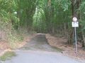
We drank some coffee, took a shower, fed the dogs and prepared to take off shopping, as, all in a sudden, the sky turned blue and rays of sun were hitting our garden, exactly at noon. So, I started to smile and said 'let us go shopping' hehe. So we left 12:30 pm, drove to a shopping hall and got out of it in less than one hour - respect goes to my wife for this! Then we drove another 20 kilometers to Niestetal, where we parked at the end of a dead-end road and I started the geohash app on my mobile phone, which showed me a 180 meters to go. Being it such a short hike, my wife came along with me on a path into the woods, untill I said the hash is another 75 meters straight into the forest from here. She told me she would wait and I made my way to reach the hash only a few minutes later. I saw two deers running away frightened (sorry for that) and located the hash without any problems. It was a big stone with a lot of feathers on it, so a bird died here recently! Took some pics, went back and found my wife collecting some seeds and flowers, and we walked the few meters back to the car...
Guess she still doesn't understand the purpose of geohashing, but luckily she also said it was nice to be out there and this will certainly not be our last geohash together ;-)
GeorgDerReisende
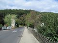
I left home at 12:20, took a tram 6 and a bus 32 and arrived at Heiligenrode at 13:40. From there I walked to the hash. The northern side of the vale looked very steep. So I walked around, may be the upper side would be flat. And it was, the hash was just at the edge to the valley. But I didn't see anybody. BTW Digiphono, do you own a black car?
Tracklog
Since this hike consisted of only 180 meters to the hash and 180 meters back to the car, I didn't track it down...
Photos
Digiphono
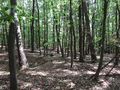
The way to the hash
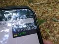
The proof
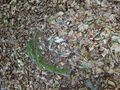
The hash - a stone on which a bird was sacrificed
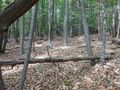
The way back from the hash


GeorgDerReisende
the other side looks steep
very steep
at above: looks good
the area of hash
the hash is at the three trees at the left

proof, for a moment I got a 2
proof, the pointer danced more than me
here is my hash
looking to the north
the east
the south
the west
GeorgDerReisende
on the way to a bus stops I was overtaken by this farmer, since then I have a new parfum


