Difference between revisions of "2018-08-31 51 5"
imported>Digiphono |
imported>FippeBot m (Location) |
||
| (3 intermediate revisions by one other user not shown) | |||
| Line 33: | Line 33: | ||
== Expedition == | == Expedition == | ||
<!-- how it all turned out. your narrative goes here. --> | <!-- how it all turned out. your narrative goes here. --> | ||
| + | I left home 10 am and drove to the dutch border in some three hours, where I took a little break, entered Slijk-Ewijk into my navigation equipment and continues my way, just to end up in a massive traffic jam only one kilometer behind the border (which is typically dutch somehow!)... So I needed almost one hour to drive some 30 kilometers to the road between Oosterhout and Slijk-Ewijk... | ||
| + | |||
| + | As I got nearer to the coords, I slowed down, pulled my car over to the side of the road and stopped. I had a look at my geohash app - and had an accuracy of 6,66 meters (pretty evil ain't it) - so I didn't even had to get ouf the car! If there would have been an achievement for the laziest form of reaching an hash, I'd have earned one today hehe... So, nothing spectacular at all - hope the next hash will be in some doomy forest or something like that, to at least do some walking again ;-) | ||
== Tracklog == | == Tracklog == | ||
| Line 41: | Line 44: | ||
Image:2012-##-## ## ## Alpha.jpg | Witty Comment | Image:2012-##-## ## ## Alpha.jpg | Witty Comment | ||
--> | --> | ||
| − | <gallery perrow=" | + | <gallery perrow="4"> |
| + | Image:2018_31_08_51_5_001.JPG | The hash was reached... | ||
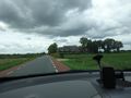
| + | Image:2018_31_08_51_5_002.JPG | ...at an almost devilish distance | ||
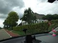
| + | Image:2018_31_08_51_5_003.JPG | The road to the hash | ||
| + | Image:2018_31_08_51_5_004.JPG | The hash - somewhere in that private garden | ||
</gallery> | </gallery> | ||
| Line 48: | Line 55: | ||
<!-- Add any achievement ribbons you earned below, or remove this section --> | <!-- Add any achievement ribbons you earned below, or remove this section --> | ||
| − | |||
| − | |||
| − | |||
| − | |||
| − | |||
| − | |||
| − | |||
| − | |||
| − | |||
| − | |||
| − | |||
| − | |||
| − | |||
| − | |||
[[Category:Expeditions]] | [[Category:Expeditions]] | ||
| − | |||
[[Category:Expeditions with photos]] | [[Category:Expeditions with photos]] | ||
| − | |||
| − | |||
| − | |||
| − | |||
| − | |||
[[Category:Coordinates reached]] | [[Category:Coordinates reached]] | ||
| − | + | {{location|NL|GE}} | |
| − | |||
| − | |||
| − | |||
| − | |||
| − | |||
| − | |||
| − | |||
| − | |||
| − | |||
| − | |||
| − | |||
| − | |||
| − | |||
| − | |||
| − | |||
| − | |||
| − | |||
Latest revision as of 04:01, 16 August 2019
| Fri 31 Aug 2018 in 51,5: 51.8845144, 5.8053193 geohashing.info google osm bing/os kml crox |
Location
On a private property between Slijk-Ewijk and Oosterhout
Participants
Plans
Since I'm driving to Amsterdam this friday, I will make a small detour to catch this geohash. Even if it seems to be located on some private property, I'm hoping to reach the hash less then 10 meters from the Oosterhoutsestraat (the local road)... Try to be there somwehere between 1 pm and 2 pm, pretty hard to estimate the exact time though. I'll be back in Germany on monday, so logs will have to wait till september 3rd...
Expedition
I left home 10 am and drove to the dutch border in some three hours, where I took a little break, entered Slijk-Ewijk into my navigation equipment and continues my way, just to end up in a massive traffic jam only one kilometer behind the border (which is typically dutch somehow!)... So I needed almost one hour to drive some 30 kilometers to the road between Oosterhout and Slijk-Ewijk...
As I got nearer to the coords, I slowed down, pulled my car over to the side of the road and stopped. I had a look at my geohash app - and had an accuracy of 6,66 meters (pretty evil ain't it) - so I didn't even had to get ouf the car! If there would have been an achievement for the laziest form of reaching an hash, I'd have earned one today hehe... So, nothing spectacular at all - hope the next hash will be in some doomy forest or something like that, to at least do some walking again ;-)
Tracklog
Photos

The hash was reached...

...at an almost devilish distance
The road to the hash
The hash - somewhere in that private garden


