Difference between revisions of "2018-09-10 49 8"
From Geohashing
imported>DODO ([retro picture]The north) |
imported>FippeBot m (Location) |
||
| (7 intermediate revisions by one other user not shown) | |||
| Line 33: | Line 33: | ||
== Expedition == | == Expedition == | ||
<!-- how it all turned out. your narrative goes here. --> | <!-- how it all turned out. your narrative goes here. --> | ||
| + | I forgot the hsh in the morning, and so I had to go there on my way back home. I was in a hurry because I had to prepare dinner, and the lady had to sing in the evening, but with the help of my bull this shouldn't take to long. It was just 10 KM further than my normal way home. | ||
| + | |||
| + | Well, what should I tell. It worked almost as planned. I found the hashfield, but had to walk 250 m into the field. I hurried back to my bull and continued my way home, where I arrived just early enough to warm up some meat and prepare some dumplings for the lady. | ||
== Tracklog == | == Tracklog == | ||
<!-- if your GPS device keeps a log, you may post a link here --> | <!-- if your GPS device keeps a log, you may post a link here --> | ||
| + | [https://www.komoot.de/tour/45863602 27 KM by bull] | ||
== Photos == | == Photos == | ||
| Line 41: | Line 45: | ||
Image:2012-##-## ## ## Alpha.jpg | Witty Comment | Image:2012-##-## ## ## Alpha.jpg | Witty Comment | ||
--> | --> | ||
| − | <gallery perrow=" | + | <gallery perrow="6"> |
| − | + | Image:2018-09-10_49_8_DODO_1537901293404.jpg|Proof oft Transport: the bull | |
| − | Image:2018-09- | + | Image:2018-09-10_49_8_DODO_1537901224764.jpg|Proof |
| − | |||
Image:2018-09-10_49_8_DODO_1537901147377.jpg|To the east | Image:2018-09-10_49_8_DODO_1537901147377.jpg|To the east | ||
| − | |||
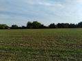
Image:2018-09-10_49_8_DODO_1537901177951.jpg|The north | Image:2018-09-10_49_8_DODO_1537901177951.jpg|The north | ||
| + | Image:2018-09-10_49_8_DODO_1537901205369.jpg|And the west | ||
| + | Image:2018-09-10_49_8_DODO_1537900643239.jpg|Happy hasher | ||
</gallery> | </gallery> | ||
| Line 53: | Line 57: | ||
{{#vardefine:ribbonwidth|800px}} | {{#vardefine:ribbonwidth|800px}} | ||
<!-- Add any achievement ribbons you earned below, or remove this section --> | <!-- Add any achievement ribbons you earned below, or remove this section --> | ||
| + | {{land geohash | ||
| + | | latitude = 49 | ||
| + | | longitude = 8 | ||
| + | | date = 2018-09-10 | ||
| + | | name = DODO | ||
| + | }} | ||
| − | |||
| − | |||
| − | |||
| − | |||
| − | |||
| − | |||
| − | |||
| − | |||
| − | |||
| − | |||
| − | |||
| − | |||
| − | |||
| − | |||
[[Category:Expeditions]] | [[Category:Expeditions]] | ||
| − | |||
| − | |||
| − | |||
| − | |||
| − | |||
| − | |||
| − | |||
[[Category:Coordinates reached]] | [[Category:Coordinates reached]] | ||
| − | + | {{location|DE|BW|HD}} | |
| − | |||
| − | |||
| − | |||
| − | |||
| − | |||
| − | |||
| − | |||
| − | |||
| − | |||
| − | |||
| − | |||
| − | |||
| − | |||
| − | |||
| − | |||
| − | |||
| − | |||
Latest revision as of 04:03, 16 August 2019
| Mon 10 Sep 2018 in 49,8: 49.3174563, 8.5286506 geohashing.info google osm bing/os kml crox |
Location
In a field near Hockenheim.
Participants
Plans
Go there on my way to the office.
Expedition
I forgot the hsh in the morning, and so I had to go there on my way back home. I was in a hurry because I had to prepare dinner, and the lady had to sing in the evening, but with the help of my bull this shouldn't take to long. It was just 10 KM further than my normal way home.
Well, what should I tell. It worked almost as planned. I found the hashfield, but had to walk 250 m into the field. I hurried back to my bull and continued my way home, where I arrived just early enough to warm up some meat and prepare some dumplings for the lady.
Tracklog
Photos
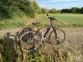
Proof oft Transport: the bull
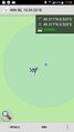
Proof
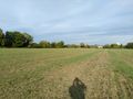
To the east
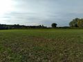
The north
And the west

Happy hasher


Achievements
DODO earned the Land geohash achievement
|