Difference between revisions of "2018-09-13 51 9"
From Geohashing
imported>GeorgDerReisende (new expedition) |
imported>FippeBot m (Location) |
||
| (2 intermediate revisions by one other user not shown) | |||
| Line 1: | Line 1: | ||
| − | |||
| − | |||
| − | |||
| − | |||
| − | |||
| − | |||
| − | |||
| − | |||
| − | |||
| − | |||
{{meetup graticule | {{meetup graticule | ||
| lat=51 | | lat=51 | ||
| Line 19: | Line 9: | ||
== Location == | == Location == | ||
| − | + | ||
| + | The geohash lies behind the car parking of the golf course at Ehlener Kreuz in the Habichtswald of Kassel. | ||
== Participants == | == Participants == | ||
| − | + | ||
| − | + | [[User:GeorgDerReisende|GeorgDerReisende]] | |
== Plans == | == Plans == | ||
| − | + | ||
| + | Tram and bus to Ehlener Kreuz, 200 meters of walking. | ||
== Expedition == | == Expedition == | ||
| − | |||
| − | + | I took two trams and a bus and arrived at the Ehlener Kreuz. I walked to the car park and found the hash four meters behind the hedge at the end of the car park. I wanted to walk around to the meadow behind, but I found the gate closed. | |
| − | |||
== Photos == | == Photos == | ||
| − | |||
| − | |||
| − | |||
<gallery perrow="5"> | <gallery perrow="5"> | ||
| + | Image:2018-09-13 51 9 GeorgDerReisende 2698.jpg | look to the hash from the bus stop | ||
| + | Image:2018-09-13 51 9 GeorgDerReisende 2702.jpg | entrance of the car park | ||
| + | Image:2018-09-13 51 9 GeorgDerReisende 2704.jpg | four meters to hash | ||
| + | Image:2018-09-13 51 9 GeorgDerReisende 2706.jpg | the gate | ||
| + | Image:2018-09-13 51 9 GeorgDerReisende 2712.jpg | more car park | ||
| + | Image:2018-09-13 51 9 GeorgDerReisende 2714.jpg | the geohasher | ||
| + | Image:2018-09-13 51 9 GeorgDerReisende 2719.jpg | the golf course | ||
</gallery> | </gallery> | ||
| Line 45: | Line 39: | ||
<!-- Add any achievement ribbons you earned below, or remove this section --> | <!-- Add any achievement ribbons you earned below, or remove this section --> | ||
| − | + | {{Public transport geohash | latitude = 51 | longitude = 9 | date = 2018-09-13 | name = GeorgDerReisende }} | |
| − | |||
| − | |||
| − | + | [[Category:Expeditions]] | |
| − | + | [[Category:Expeditions with photos]] | |
| − | |||
| − | |||
| − | |||
| − | |||
| − | |||
| − | |||
| − | |||
| − | |||
| − | |||
| − | |||
| − | |||
| − | |||
| − | |||
| − | |||
[[Category:Coordinates reached]] | [[Category:Coordinates reached]] | ||
| − | + | {{location|DE|HE|KS|city=true}} | |
| − | |||
| − | |||
| − | |||
| − | |||
| − | |||
| − | |||
| − | |||
| − | |||
| − | |||
| − | |||
| − | |||
| − | |||
| − | |||
| − | |||
| − | |||
| − | |||
| − | |||
Latest revision as of 04:04, 16 August 2019
| Thu 13 Sep 2018 in 51,9: 51.3136972, 9.3726092 geohashing.info google osm bing/os kml crox |
Location
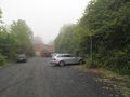
The geohash lies behind the car parking of the golf course at Ehlener Kreuz in the Habichtswald of Kassel.
Participants
Plans
Tram and bus to Ehlener Kreuz, 200 meters of walking.
Expedition
I took two trams and a bus and arrived at the Ehlener Kreuz. I walked to the car park and found the hash four meters behind the hedge at the end of the car park. I wanted to walk around to the meadow behind, but I found the gate closed.
Photos
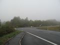
look to the hash from the bus stop
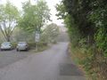
entrance of the car park
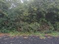
four meters to hash
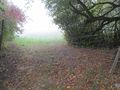
the gate
more car park
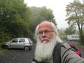
the geohasher
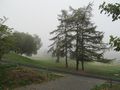
the golf course


Achievements
GeorgDerReisende earned the Public transport geohash achievement
|