Difference between revisions of "2018-09-24 51 9"
imported>Digiphono (→Plans) |
imported>FippeBot m (Location) |
||
| (9 intermediate revisions by one other user not shown) | |||
| Line 20: | Line 20: | ||
== Location == | == Location == | ||
<!-- where you've surveyed the hash to be --> | <!-- where you've surveyed the hash to be --> | ||
| − | In a small wooded area near | + | In a small wooded area near Hübenthal, little west of Sontra |
== Participants == | == Participants == | ||
| Line 29: | Line 29: | ||
== Plans == | == Plans == | ||
<!-- what were the original plans --> | <!-- what were the original plans --> | ||
| − | Before my late shift | + | Before my late shift at work, I will drive to Sontra / Hübenthal and walk to the hash around noon... |
== Expedition == | == Expedition == | ||
| − | + | ||
| + | I left home 11:30 am and arrived at noon. Originally I wanted to come from the east, through a village called Donnershag, but even if Google recommended me this road, it was forbidden to drive there! So I drove a small detour of some kilometers and 10 minutes later I arrived from the west. I decided to park my car in Hübenthal, which are only a few farms and some houses - and people were looking from behind their windows to see, what this stranger was doing here... | ||
| + | |||
| + | Perhaps this annoyed me a little bit, so I took the first path I saw, which led me directly into a forest. Looked fine. Untill I got further, and noticed I actually took the wrong way. But I didn't want to turn around, so I found myself a way through the small forest and managed to get out of it in less then hundred meters from the hash! There I found a harvested field and I walked along the border of it - the forest to the left, the field to the right. A few minutes later, I reached the hash and took some pictures. | ||
| + | |||
| + | I continued my way and now I got on the road that I wanted to walk whilst planning my expedition yesterday. Indeed, this one was much easier haha! Nevertheless, this small hike made fun and satisfied I returned to my car in only half an hour. When driving back to the main road, I noticed a cemetery, where I parked my car and did another small walk and took a few pictures of some very old tombstones. | ||
| + | |||
| + | The atmosphere was great and I almost forgot time, so I had to hurry to get to work in time! | ||
== Tracklog == | == Tracklog == | ||
| − | < | + | |
| + | <gallery> | ||
| + | Image:2018-09-24_51_9_002.jpg | The tracklog of todays hike | ||
| + | </gallery> | ||
== Photos == | == Photos == | ||
| Line 41: | Line 51: | ||
Image:2012-##-## ## ## Alpha.jpg | Witty Comment | Image:2012-##-## ## ## Alpha.jpg | Witty Comment | ||
--> | --> | ||
| − | <gallery | + | <gallery> |
| + | Image:2018-09-24_51_9_001.jpg | The location of the hash | ||
| + | Image:2018-09-24_51_9_003.jpg | The way to the hash | ||
| + | Image:2018-09-24_51_9_004.jpg | The way to the hash | ||
| + | Image:2018-09-24_51_9_005.jpg | The forest near the hash | ||
| + | Image:2018-09-24_51_9_006.jpg | The location of the hash | ||
| + | Image:2018-09-24_51_9_007.jpg | The hash - proof | ||
| + | Image:2018-09-24_51_9_008.jpg | The cemetery of Hübenthal | ||
</gallery> | </gallery> | ||
| Line 48: | Line 65: | ||
<!-- Add any achievement ribbons you earned below, or remove this section --> | <!-- Add any achievement ribbons you earned below, or remove this section --> | ||
| − | + | {{consecutive geohash 2 | |
| − | + | | count = 4 | |
| − | + | | latitude = 51 | |
| − | + | | longitude = 9 | |
| − | + | | date = 2018-09-21 | |
| + | | name = Digiphono | ||
| + | }} | ||
| + | {{Last man standing | ||
| + | | latitude = 51 | ||
| + | | longitude = 9 | ||
| + | | date = 2018-09-24 | ||
| + | | gender = man | ||
| + | | name = Digiphono | ||
| + | }} | ||
| − | |||
| − | |||
| − | |||
| − | |||
| − | |||
| − | |||
| − | |||
| − | |||
[[Category:Expeditions]] | [[Category:Expeditions]] | ||
| − | |||
[[Category:Expeditions with photos]] | [[Category:Expeditions with photos]] | ||
| − | |||
| − | |||
| − | |||
| − | |||
| − | |||
[[Category:Coordinates reached]] | [[Category:Coordinates reached]] | ||
| − | + | {{location|DE|HE|WIZ}} | |
| − | |||
| − | |||
| − | |||
| − | |||
| − | |||
| − | |||
| − | |||
| − | |||
| − | |||
| − | |||
| − | |||
| − | |||
| − | |||
| − | |||
| − | |||
| − | |||
| − | |||
Latest revision as of 04:08, 16 August 2019
| Mon 24 Sep 2018 in 51,9: 51.0737245, 9.9040806 geohashing.info google osm bing/os kml crox |
Location
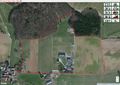
In a small wooded area near Hübenthal, little west of Sontra
Participants
Plans
Before my late shift at work, I will drive to Sontra / Hübenthal and walk to the hash around noon...
Expedition
I left home 11:30 am and arrived at noon. Originally I wanted to come from the east, through a village called Donnershag, but even if Google recommended me this road, it was forbidden to drive there! So I drove a small detour of some kilometers and 10 minutes later I arrived from the west. I decided to park my car in Hübenthal, which are only a few farms and some houses - and people were looking from behind their windows to see, what this stranger was doing here...
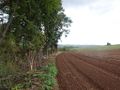
Perhaps this annoyed me a little bit, so I took the first path I saw, which led me directly into a forest. Looked fine. Untill I got further, and noticed I actually took the wrong way. But I didn't want to turn around, so I found myself a way through the small forest and managed to get out of it in less then hundred meters from the hash! There I found a harvested field and I walked along the border of it - the forest to the left, the field to the right. A few minutes later, I reached the hash and took some pictures.
I continued my way and now I got on the road that I wanted to walk whilst planning my expedition yesterday. Indeed, this one was much easier haha! Nevertheless, this small hike made fun and satisfied I returned to my car in only half an hour. When driving back to the main road, I noticed a cemetery, where I parked my car and did another small walk and took a few pictures of some very old tombstones.
The atmosphere was great and I almost forgot time, so I had to hurry to get to work in time!
Tracklog
The tracklog of todays hike

Photos
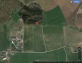
The location of the hash
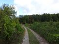
The way to the hash
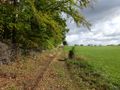
The way to the hash
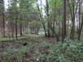
The forest near the hash
The location of the hash
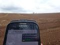
The hash - proof
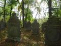
The cemetery of Hübenthal


Achievements
Digiphono earned the Consecutive geohash achievement
|
Digiphono earned the Last man standing achievement
|