Difference between revisions of "2018-09-27 42 -85"
imported>FippeBot m (Location) |
m |
||
| Line 61: | Line 61: | ||
[[Category:Expeditions]] | [[Category:Expeditions]] | ||
[[Category:Expeditions with photos]] | [[Category:Expeditions with photos]] | ||
| + | [[Category:Coordinates not reached]] | ||
[[Category:Not reached - Mother Nature]] | [[Category:Not reached - Mother Nature]] | ||
{{location|US|MI|OT}} | {{location|US|MI|OT}} | ||
Latest revision as of 11:21, 12 September 2021
| Thu 27 Sep 2018 in 42,-85: 42.9651340, -85.7884560 geohashing.info google osm bing/os kml crox |
Location
powerline right-of-way just south of Rosedale Memorial Park, Walker, MI
Participants
Expedition
Looked easy, under powerlines just south of a large graveyard I had already visited on 2016-08-29_42_-85. I took the same approach: get off the bus at an intermediate stop during my commute home and walk.
Turns out this one was harder. I walked through the graveyard to its southeast corner, where a utility road led to the power lines. The right-of-way was covered with thick vegetation 6-12 feet high. Quite a bit of poking around led to no reasonable path toward the hashpoint.
I returned to the graveyard, walked to its southwest corner, made my way through the hedge to 2nd Avenue, and walked south to where the right-of-way crossed the road. This was no better: a steep bank up to the right-of-way, which looked just as impenetrable as it had from the other end. In my work clothes and not equipped with a machete, I gave up.
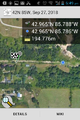
Closest approach from east.
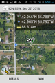
Closest approach from west.
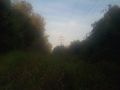
Thicket, from east.

Grin.
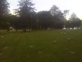
Graveyard, near hashpoint from 2016-08-29_42_-85.


Achievements
George earned the No trespassing consolation prize
|