Difference between revisions of "2018-10-02 51 9"
imported>Digiphono (→Plans) |
imported>FippeBot m (Location) |
||
| (2 intermediate revisions by one other user not shown) | |||
| Line 20: | Line 20: | ||
== Location == | == Location == | ||
| − | On a meadow little | + | On a meadow little north of Hausen on the Hohe Meißner |
== Participants == | == Participants == | ||
| Line 53: | Line 53: | ||
<!-- Add any achievement ribbons you earned below, or remove this section --> | <!-- Add any achievement ribbons you earned below, or remove this section --> | ||
| − | |||
| − | |||
| − | |||
| − | |||
| − | |||
| − | |||
| − | |||
| − | |||
| − | |||
| − | |||
| − | |||
| − | |||
| − | |||
| − | |||
[[Category:Expeditions]] | [[Category:Expeditions]] | ||
| − | |||
[[Category:Expeditions with photos]] | [[Category:Expeditions with photos]] | ||
| − | |||
| − | |||
| − | |||
| − | |||
| − | |||
[[Category:Coordinates reached]] | [[Category:Coordinates reached]] | ||
| − | + | {{location|DE|HE|WIZ}} | |
| − | |||
| − | |||
| − | |||
| − | |||
| − | |||
| − | |||
| − | |||
| − | |||
| − | |||
| − | |||
| − | |||
| − | |||
| − | |||
| − | |||
| − | |||
| − | |||
| − | |||
Latest revision as of 04:09, 16 August 2019
| Tue 2 Oct 2018 in 51,9: 51.2116664, 9.8240744 geohashing.info google osm bing/os kml crox |
Location
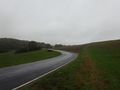
On a meadow little north of Hausen on the Hohe Meißner
Participants
Plans
I will drive by there after work and expect to be there somewhere around 14:15 pm - I'll take some boots for dirty walks with me, since it's raining a lot at the moment and if the hash lies on a field rather than on a meadow, it might get muddy!
Expedition
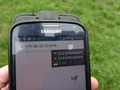
Since this hash was only two kilometers away from my daily route to work, I directed to the small village Hausen after work and parked my car directly only 200 meters from the hash. As expected, the weather was pretty wet, somewhat cold and really windy - perfect for doing a hash! This was an easy one - the field was indeed a field with grass, no mud at all, so I needed less than two minutes to reach the hash and take some pictures. Let's call it a 'park and grap' hash hehe... Nothing spectacular, nothing more to write...
Tracklog
Photos
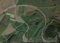
The location of the hash
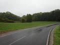
The parking lot

The hasher only some meters away from the hash
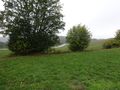
The hash location
The hash - proof

The hash - screenshot
The parking lot again


