Difference between revisions of "2018-10-03 51 9"
imported>Digiphono (→Plans) |
imported>FippeBot m (Location) |
||
| (9 intermediate revisions by 2 users not shown) | |||
| Line 1: | Line 1: | ||
| − | |||
| − | |||
| − | |||
| − | |||
| − | |||
| − | |||
| − | |||
| − | |||
| − | |||
| − | |||
{{meetup graticule | {{meetup graticule | ||
| lat=51 | | lat=51 | ||
| Line 32: | Line 22: | ||
No actual planning was done, but we decided to visit this hash rather spontaneously. | No actual planning was done, but we decided to visit this hash rather spontaneously. | ||
| + | |||
| + | ====GeorgDerReisende==== | ||
| + | |||
| + | At the first glance an easy one. Why not. | ||
== Expedition == | == Expedition == | ||
| − | + | ||
| + | ====Digiphono==== | ||
| + | |||
| + | We left home 12:30 pm and drove to the cemetery of Hemeln in 45 minutes. We parked our car and did a 1,5 kilometer hike to the hash, through a wonderful forest, over an abandoned path, that was grown with plants and having some trees as obstacles on our way. Still, the path was quite ok, so we reached the hash within 20 minutes and took some pictures, enjoyed the silence and the beautiful weather as well... At the hash, we found some well-seasoned firewood, which someone made ages ago but probably never turned back for transporting it back home - now the wood worms are enjoying it and the rest will rot away during the next decades! | ||
| + | |||
| + | After our trip, we visited a geocache at the near camping site, where we noticed [[User:GeorgDerReisende|GeorgDerReisende]] on his way to the geohash. What a coincidence! We shouted his name and whistled through our fingers, but he didn't notice us, so we let him walk his journey to the hash - I hope you made it through the somewhat rough terrain ;-) | ||
| + | |||
| + | On our way back we made a stop in Hannoversch Münden to visit the point, where the rivers Werra and Fulda confluence to become the [https://en.wikipedia.org/wiki/Weser Weser]. There were many people here, since today (October 3rd) is the [https://en.wikipedia.org/wiki/German_Unity_Day German Unification Day], where all citizens have a day off to celebrate this historic Unification of the BRD and DDR in 1990! After a nice day, we went back home satisfied... | ||
| + | |||
| + | ====GeorgDerReisende==== | ||
| + | |||
| + | I left home at 10:45 and with a tram, a regiotram, a bus and a ferry I arrived at Hemeln. At the beginning it was a usual forest way, but further on it was getting too rough for me. Going a dangerous path ahead is not always lucky and knowing, I have to go this path twice is nothing for me at the moment. | ||
== Tracklog == | == Tracklog == | ||
| − | < | + | |
| + | <gallery> | ||
| + | Image:2018-10-03_51_9_009.jpg | Today's track [Digiphono] | ||
| + | </gallery> | ||
== Photos == | == Photos == | ||
| − | < | + | |
| − | Image: | + | ====Digiphono==== |
| − | --> | + | |
| − | <gallery | + | <gallery> |
| + | Image:2018-10-03_51_9_001.jpg | The location of the hash | ||
| + | Image:2018-10-03_51_9_002.jpg | The way to the hash | ||
| + | Image:2018-10-03_51_9_003.jpg | The way to the hash | ||
| + | Image:2018-10-03_51_9_004.jpg | The way to the hash | ||
| + | Image:2018-10-03_51_9_005.jpg | The hasher, locating the hash | ||
| + | Image:2018-10-03_51_9_006.jpg | The wife at the hash location | ||
| + | Image:2018-10-03_51_9_007.jpg | The hash - proof | ||
| + | Image:2018-10-03_51_9_008.jpg | The hash - screenshot | ||
| + | </gallery> | ||
| + | |||
| + | ====GeorgDerReisende==== | ||
| + | <gallery> | ||
| + | Image:2018-10-03 51 9 GeorgDerReisende 5965.jpg | the hill north of Hemeln | ||
| + | Image:2018-10-03 51 9 GeorgDerReisende 5968.jpg | 800 meters to the hash | ||
| + | Image:2018-10-03 51 9 GeorgDerReisende 5972.jpg | 400 meters to the hash | ||
</gallery> | </gallery> | ||
| Line 50: | Line 73: | ||
<!-- Add any achievement ribbons you earned below, or remove this section --> | <!-- Add any achievement ribbons you earned below, or remove this section --> | ||
| − | |||
| − | |||
| − | |||
| − | |||
| − | |||
| − | |||
| − | |||
| − | |||
| − | |||
| − | |||
| − | |||
| − | |||
| − | |||
| − | |||
[[Category:Expeditions]] | [[Category:Expeditions]] | ||
| − | |||
[[Category:Expeditions with photos]] | [[Category:Expeditions with photos]] | ||
| − | |||
| − | |||
| − | |||
| − | |||
| − | |||
[[Category:Coordinates reached]] | [[Category:Coordinates reached]] | ||
| − | + | {{location|DE|NI|GÖ}} | |
| − | |||
| − | |||
| − | |||
| − | |||
| − | |||
| − | |||
| − | |||
| − | |||
| − | |||
| − | |||
| − | |||
| − | |||
| − | |||
| − | |||
| − | |||
| − | |||
| − | |||
Latest revision as of 04:10, 16 August 2019
| Wed 3 Oct 2018 in 51,9: 51.5118069, 9.5968761 geohashing.info google osm bing/os kml crox |
Location
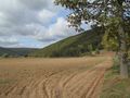
In a forest little north of Hemeln
Participants
- Digiphono and his wife
- GeorgDerReisende
Plans
Digiphono
No actual planning was done, but we decided to visit this hash rather spontaneously.
GeorgDerReisende
At the first glance an easy one. Why not.
Expedition
Digiphono
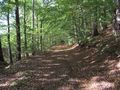
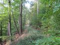
We left home 12:30 pm and drove to the cemetery of Hemeln in 45 minutes. We parked our car and did a 1,5 kilometer hike to the hash, through a wonderful forest, over an abandoned path, that was grown with plants and having some trees as obstacles on our way. Still, the path was quite ok, so we reached the hash within 20 minutes and took some pictures, enjoyed the silence and the beautiful weather as well... At the hash, we found some well-seasoned firewood, which someone made ages ago but probably never turned back for transporting it back home - now the wood worms are enjoying it and the rest will rot away during the next decades!
After our trip, we visited a geocache at the near camping site, where we noticed GeorgDerReisende on his way to the geohash. What a coincidence! We shouted his name and whistled through our fingers, but he didn't notice us, so we let him walk his journey to the hash - I hope you made it through the somewhat rough terrain ;-)
On our way back we made a stop in Hannoversch Münden to visit the point, where the rivers Werra and Fulda confluence to become the Weser. There were many people here, since today (October 3rd) is the German Unification Day, where all citizens have a day off to celebrate this historic Unification of the BRD and DDR in 1990! After a nice day, we went back home satisfied...
GeorgDerReisende
I left home at 10:45 and with a tram, a regiotram, a bus and a ferry I arrived at Hemeln. At the beginning it was a usual forest way, but further on it was getting too rough for me. Going a dangerous path ahead is not always lucky and knowing, I have to go this path twice is nothing for me at the moment.
Tracklog
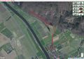
Today's track [Digiphono]

Photos
Digiphono
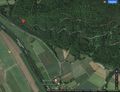
The location of the hash
The way to the hash
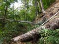
The way to the hash
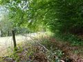
The way to the hash
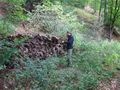
The hasher, locating the hash
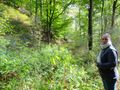
The wife at the hash location
The hash - proof
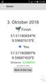
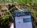
The hash - screenshot


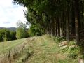
GeorgDerReisende
the hill north of Hemeln
800 meters to the hash
400 meters to the hash


