Difference between revisions of "2018-10-05 49 8"
imported>DODO ([live picture]cabbage?) |
imported>FippeBot m (Location) |
||
| (5 intermediate revisions by one other user not shown) | |||
| Line 45: | Line 45: | ||
Image:2012-##-## ## ## Alpha.jpg | Witty Comment | Image:2012-##-## ## ## Alpha.jpg | Witty Comment | ||
--> | --> | ||
| − | <gallery perrow=" | + | <gallery perrow="6"> |
| − | + | Image:2018-10-05_49_8_DODO_1538768148899.jpg|First lane I tried | |
| + | Image:2018-10-05_49_8_DODO_1538768083979.jpg|cabbage? | ||
| + | Image:Screenshot_2018-10-05-17-45-47.jpg|proof | ||
Image:2018-10-05_49_8_DODO_1538766722034.jpg|Happy hasher | Image:2018-10-05_49_8_DODO_1538766722034.jpg|Happy hasher | ||
| − | + | Image:2018-10-05_49_8_DODO_1538768175348.jpg|View to the bull | |
| − | Image:2018-10- | + | Image:2018-10-05_49_8_DODO_1538768208391.jpg|View to the west |
| − | |||
| − | |||
| − | |||
| − | Image:2018-10- | ||
</gallery> | </gallery> | ||
| Line 60: | Line 58: | ||
<!-- Add any achievement ribbons you earned below, or remove this section --> | <!-- Add any achievement ribbons you earned below, or remove this section --> | ||
| − | + | {{land geohash | |
| − | + | | latitude = 49 | |
| − | + | | longitude = 8 | |
| + | | date = 2018-10-05 | ||
| + | | name = DODO | ||
| + | }} | ||
| − | |||
| − | |||
| − | |||
| − | |||
| − | |||
| − | |||
| − | |||
| − | |||
| − | |||
| − | |||
[[Category:Expeditions]] | [[Category:Expeditions]] | ||
| − | |||
| − | |||
| − | |||
| − | |||
| − | |||
| − | |||
| − | |||
[[Category:Coordinates reached]] | [[Category:Coordinates reached]] | ||
| − | + | {{location|DE|RP|RP}} | |
| − | |||
| − | |||
| − | |||
| − | |||
| − | |||
| − | |||
| − | |||
| − | |||
| − | |||
| − | |||
| − | |||
| − | |||
| − | |||
| − | |||
| − | |||
| − | |||
| − | |||
Latest revision as of 03:20, 7 August 2019
| Fri 5 Oct 2018 in 49,8: 49.3165722, 8.3206983 geohashing.info google osm bing/os kml crox |
Location
A field near Hanhofen
Participants
Plans
I thought about visiting the hash on my way to the office, but forgot about it this morning. So I decided to visit it on my way home. Well, to be honest, my home was on the way from the office to the hash, but I don't wnat to visit it inbetween.
Expedition
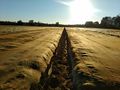
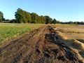
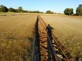
Well, almost just as planned. I started to track my way when I was close to home, so I have just the additional way on the track. I was on my bull, so the 8 Km to the hash were done in 20 minutes. I knew the way quite well, as I have used it for several hashes before. In Hanhofen I had to cross a bridge over a Bundesstraße (national street), and entered an area that was new for me. 3 minutes later I had reached the hashfield. It was completly covered with tissue, and some sort of cabbage seemes to grow beyond the material. It seemed like a no go :-)
But then I realised that the tissue was fixed in long sheets and there was some ground between them. Maybe I can reach the hash by following one of them. I had to change to the short side of the field to do so and indeed the ground was wide enough to walk between the material without causing any damage (I hope). I tried to find the lane, that was orthogonal to the side of the field to come to the hash and walked 60 m into the field. But I was to far to theright, and missed the hash by 8 m. So I decided to walk back and take the next lane (always fearing that somebody would stop me). But noone came, and in the next lane I reached the hash - well, 3 m is good enough? I stretched my arm and got 2,3m, but I caugth it only some dm later. Anyway, clearly within the cyrcle. Success :-)
Tracklog
Photos
First lane I tried
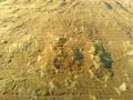
cabbage?
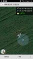
proof

Happy hasher
View to the bull
View to the west


Achievements
DODO earned the Land geohash achievement
|