Difference between revisions of "2018-10-27 46 -118"
imported>Michael5000 |
imported>FippeBot m (Location) |
||
| (4 intermediate revisions by one other user not shown) | |||
| Line 32: | Line 32: | ||
== Expedition == | == Expedition == | ||
| − | + | ||
| + | The shoulder wasn't nearly as wide in real life as it looked in the imagery, so it was a nervous walk of a couple hundred meters from a wide spot where we were able to park the car. We both felt like we heard cars coming while we walked, crunch crunch crunch, through the gravel, but as soon as we stopped the big silence of the wheatlands made itself powerfully felt. Once or twice, a car or truck actually did go by. | ||
| + | |||
| + | We took our pictures, returned to the car, and continued along our way. | ||
== Photos == | == Photos == | ||
| − | + | ||
| − | |||
| − | |||
<gallery perrow="5"> | <gallery perrow="5"> | ||
| + | File:2018-10-27 46 -118 people.jpg|The 5000s triumphant. | ||
| + | File:2018-10-27 46 -118 road 1.jpg|The road north. | ||
| + | File:2018-10-27 46 -118 road 2.jpg|The road south. | ||
| + | File:2018-10-27 46 -118 bear.jpg|The intrepid traveling mascot. | ||
</gallery> | </gallery> | ||
== Achievements == | == Achievements == | ||
{{#vardefine:ribbonwidth|800px}} | {{#vardefine:ribbonwidth|800px}} | ||
| − | |||
| − | |||
| − | |||
| − | |||
| − | |||
| − | |||
| − | + | It was the first successful expedition in the Walla Walla graticule in five years, five months, and ten days! | |
| − | |||
[[Category:Expeditions]] | [[Category:Expeditions]] | ||
| − | |||
[[Category:Expeditions with photos]] | [[Category:Expeditions with photos]] | ||
| − | |||
| − | |||
| − | |||
| − | |||
| − | |||
[[Category:Coordinates reached]] | [[Category:Coordinates reached]] | ||
| − | + | {{location|US|WA|AD}} | |
| − | |||
| − | |||
| − | |||
| − | |||
| − | |||
| − | |||
| − | |||
| − | |||
| − | |||
| − | |||
| − | |||
| − | |||
| − | |||
| − | |||
| − | |||
| − | |||
| − | |||
Latest revision as of 03:21, 7 August 2019
| Sat 27 Oct 2018 in 46,-118: 46.8746330, -118.5543579 geohashing.info google osm bing/os kml crox |
Location
On the shoulder of Washington Highway 21, in the middle of nowhere.
Participants
Plans
The 5000s will be travelling southwest on US 385 in the afternoon, and will take the short detour to admire and photograph the spot.
Expedition
The shoulder wasn't nearly as wide in real life as it looked in the imagery, so it was a nervous walk of a couple hundred meters from a wide spot where we were able to park the car. We both felt like we heard cars coming while we walked, crunch crunch crunch, through the gravel, but as soon as we stopped the big silence of the wheatlands made itself powerfully felt. Once or twice, a car or truck actually did go by.
We took our pictures, returned to the car, and continued along our way.
Photos

The 5000s triumphant.

The road north.
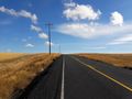
The road south.

The intrepid traveling mascot.


Achievements
It was the first successful expedition in the Walla Walla graticule in five years, five months, and ten days!