Difference between revisions of "2018-12-02 51 9"
imported>Digiphono (→Tracklog) |
imported>FippeBot m (Location) |
||
| (6 intermediate revisions by one other user not shown) | |||
| Line 20: | Line 20: | ||
== Location == | == Location == | ||
| − | + | Between a field way and the Holzape brook near Beberbeck. | |
== Participants == | == Participants == | ||
| Line 38: | Line 38: | ||
== Expedition == | == Expedition == | ||
| − | When I woke up this morning 8 am, I already knew, this was going to become a wet one! It was raining without | + | When I woke up this morning 8 am, I already knew, this was going to become a wet one! It was raining without end, so I listened to the weather forecast on the radio: after noon, it would become better and drier, so I hoped for that and left home 9 am (without reading GeorgDerReisende's message, that he cancelled his trip). I had to drive some 65 kilometers and all the way it was raining... |
I did two stops to find some geohashes and became pretty wet after being out of the car for only ten minutes maybe. So I dediced to continue my way to do the hash first, and do the rest of the caches after that. When I studied the map yesterday evening, I planned to drive to Beberbeck, where a field road was leading almost directly to the hash. Maybe some 500 meters to walk, and I would reach the hash - so were my plans, because Georg had warned my about a ford that I had to cross, if coming from the other direction... | I did two stops to find some geohashes and became pretty wet after being out of the car for only ten minutes maybe. So I dediced to continue my way to do the hash first, and do the rest of the caches after that. When I studied the map yesterday evening, I planned to drive to Beberbeck, where a field road was leading almost directly to the hash. Maybe some 500 meters to walk, and I would reach the hash - so were my plans, because Georg had warned my about a ford that I had to cross, if coming from the other direction... | ||
| Line 44: | Line 44: | ||
When I entered Beberbeck, I noticed that this wasn't a village, but a huge old state farm, with many signs saying "no tresspassing"! The road I planned (the blue one on the map) was closed with a barrier. Hm... What do I do? I turned around, and parked my car a little off of the buildings and started to walk. Reaching the farm by feet, the 'blue road' seemed unaccesible, so I decided to walk the alternative route, knowing that the ford would be on my way. After passing some 'dead-end-signs', I knew, the ford will become my problem... | When I entered Beberbeck, I noticed that this wasn't a village, but a huge old state farm, with many signs saying "no tresspassing"! The road I planned (the blue one on the map) was closed with a barrier. Hm... What do I do? I turned around, and parked my car a little off of the buildings and started to walk. Reaching the farm by feet, the 'blue road' seemed unaccesible, so I decided to walk the alternative route, knowing that the ford would be on my way. After passing some 'dead-end-signs', I knew, the ford will become my problem... | ||
| − | Well, crossing the ford was indeed impossible, so I searched along the | + | Well, crossing the ford was indeed impossible, so I searched along the brook, for a possible opportunity to cross it. At some point, the brook was only one meter in width, so I could take a step on some stones and managed to cross the Holzape (the name of the small stream). In the meanwhile, the rain got heavier and soon I was soaking wet - my shoes and socks were pretty swampy already, but I continued the last 800 meters and reached the hash at 11:15 am. There was no GeorgDerReisende there, so I made some pictures for proof - the hash was near a deerstand, behind a sign saying 'wildlife reserve'... |
| − | On my way back I took a better option across the | + | On my way back I took a better option across the brook, which I already noticed before, and walked some hundred meters over a field and finally got back on the main road to the farm again. I also came across an abandoned house and took some pics... Back at the farm, I entered the private property carefully, and I found the 'blue' road - leading between two houses, but accessible for pedestrians - so I '''had''' been able to walk the originally planned road, instead of a 5,5 km hike hehe... This didn't bother me though, the little adventure was great enough, and I didn't regret going there today. |
== Tracklog == | == Tracklog == | ||
| Line 55: | Line 55: | ||
== Photos == | == Photos == | ||
| − | < | + | |
| − | Image: | + | <gallery> |
| − | -- | + | Image:2018-12-02_51_9_001.jpg | The road was closed |
| − | + | Image:2018-12-02_51_9_002.jpg | The old state farm | |
| + | Image:2018-12-02_51_9_003.jpg | Another fence obstructing my way | ||
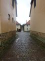
| + | Image:2018-12-02_51_9_004.jpg | So I walked down this alley | ||
| + | Image:2018-12-02_51_9_005.jpg | And found this dead-end sign | ||
| + | Image:2018-12-02_51_9_006.jpg | Hm, how do I get through | ||
| + | Image:2018-12-02_51_9_007.jpg | Here I was able to cross the brook | ||
| + | Image:2018-12-02_51_9_008.jpg | The hash location | ||
| + | Image:2018-12-02_51_9_009.jpg | The (wet) hasher at the hash location | ||
| + | Image:2018-12-02_51_9_010.jpg | The hash - proof | ||
| + | Image:2018-12-02_51_9_011.jpg | A better place to cross the brook | ||
| + | Image:2018-12-02_51_9_012.jpg | Being soaking wet | ||
| + | Image:2018-12-02_51_9_013.jpg | At the abandoned house | ||
| + | Image:2018-12-02_51_9_014.jpg | Somewhat spooky | ||
| + | Image:2018-12-02_51_9_016.jpg | The 'blue' road I discovered at the end | ||
</gallery> | </gallery> | ||
== Achievements == | == Achievements == | ||
{{#vardefine:ribbonwidth|800px}} | {{#vardefine:ribbonwidth|800px}} | ||
| − | |||
| − | + | {{Drowned rat geohash | latitude = 51 | longitude = 9 | date = 2018-12-02 | name = Digiphono | image = 2018-12-02_51_9_009.jpg | reason = walking in pouring rain }} | |
| − | |||
| − | |||
| − | |||
| − | |||
| − | |||
| − | |||
| − | |||
| − | |||
| − | |||
[[Category:Expeditions]] | [[Category:Expeditions]] | ||
| − | |||
[[Category:Expeditions with photos]] | [[Category:Expeditions with photos]] | ||
| − | |||
| − | |||
| − | |||
| − | |||
| − | |||
[[Category:Coordinates reached]] | [[Category:Coordinates reached]] | ||
| − | + | {{location|DE|HE|KS}} | |
| − | |||
| − | |||
| − | |||
| − | |||
| − | |||
| − | |||
| − | |||
| − | |||
| − | |||
| − | |||
| − | |||
| − | |||
| − | |||
| − | |||
| − | |||
| − | |||
| − | |||
Latest revision as of 04:18, 16 August 2019
| Sun 2 Dec 2018 in 51,9: 51.5356460, 9.4995896 geohashing.info google osm bing/os kml crox |
Location
Between a field way and the Holzape brook near Beberbeck.
Participants
Plans
Digiphono wants to be there at 11 a.m., GeorgDerReisende too. There is a forth on the shortest way, look at the end of 2015-06-21 51 9. - Georg, it's Digiphono, with an O at the end hehe... Thanks for mentioning the ford - I will come from the south then, to avoid soaking wet shoes, coz I am planning a bike-tour after the hash! See you tomorrow ;-)
I cancel this trip now. There is a heavy rain cloud approaching, about some days thick. This is nothing for me at the moment. --GeorgDerReisende (talk) 06:25, 2 December 2018 (UTC)

Expedition
When I woke up this morning 8 am, I already knew, this was going to become a wet one! It was raining without end, so I listened to the weather forecast on the radio: after noon, it would become better and drier, so I hoped for that and left home 9 am (without reading GeorgDerReisende's message, that he cancelled his trip). I had to drive some 65 kilometers and all the way it was raining...
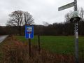
I did two stops to find some geohashes and became pretty wet after being out of the car for only ten minutes maybe. So I dediced to continue my way to do the hash first, and do the rest of the caches after that. When I studied the map yesterday evening, I planned to drive to Beberbeck, where a field road was leading almost directly to the hash. Maybe some 500 meters to walk, and I would reach the hash - so were my plans, because Georg had warned my about a ford that I had to cross, if coming from the other direction...
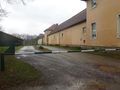
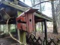
When I entered Beberbeck, I noticed that this wasn't a village, but a huge old state farm, with many signs saying "no tresspassing"! The road I planned (the blue one on the map) was closed with a barrier. Hm... What do I do? I turned around, and parked my car a little off of the buildings and started to walk. Reaching the farm by feet, the 'blue road' seemed unaccesible, so I decided to walk the alternative route, knowing that the ford would be on my way. After passing some 'dead-end-signs', I knew, the ford will become my problem...
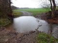
Well, crossing the ford was indeed impossible, so I searched along the brook, for a possible opportunity to cross it. At some point, the brook was only one meter in width, so I could take a step on some stones and managed to cross the Holzape (the name of the small stream). In the meanwhile, the rain got heavier and soon I was soaking wet - my shoes and socks were pretty swampy already, but I continued the last 800 meters and reached the hash at 11:15 am. There was no GeorgDerReisende there, so I made some pictures for proof - the hash was near a deerstand, behind a sign saying 'wildlife reserve'...
On my way back I took a better option across the brook, which I already noticed before, and walked some hundred meters over a field and finally got back on the main road to the farm again. I also came across an abandoned house and took some pics... Back at the farm, I entered the private property carefully, and I found the 'blue' road - leading between two houses, but accessible for pedestrians - so I had been able to walk the originally planned road, instead of a 5,5 km hike hehe... This didn't bother me though, the little adventure was great enough, and I didn't regret going there today.
Tracklog
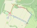
Today's track (blue was planned, red I went)

Photos
The road was closed
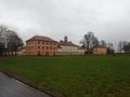
The old state farm

Another fence obstructing my way

So I walked down this alley
And found this dead-end sign
Hm, how do I get through

Here I was able to cross the brook
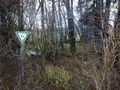
The hash location
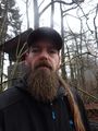
The (wet) hasher at the hash location
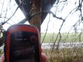
The hash - proof
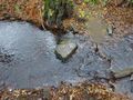
A better place to cross the brook
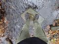
Being soaking wet
At the abandoned house
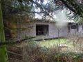
Somewhat spooky
The 'blue' road I discovered at the end


Achievements
Digiphono earned the Drowned Rat Geohash Achievement
|