Difference between revisions of "2018-12-04 51 9"
imported>Digiphono (Created page with "{{subst:Expedition |lat = 51 |lon = 9 |date = 2018-12-04 }}") |
imported>Digiphono |
||
| Line 1: | Line 1: | ||
| − | |||
| − | |||
| − | |||
| − | |||
| − | |||
| − | |||
| − | |||
| − | |||
| − | |||
| − | |||
{{meetup graticule | {{meetup graticule | ||
| lat=51 | | lat=51 | ||
| Line 15: | Line 5: | ||
}} | }} | ||
| − | |||
__NOTOC__ | __NOTOC__ | ||
== Location == | == Location == | ||
| − | + | ||
| + | In a forest near Großalmerode | ||
== Participants == | == Participants == | ||
| − | + | ||
| − | + | [[User:Digiphono|Digiphono]] | |
== Plans == | == Plans == | ||
| − | + | ||
| + | I want to drive there before I go to work and do a hike to the hash and then continue my way to work. | ||
== Expedition == | == Expedition == | ||
| − | |||
| − | + | As planned, I left home earlier and arrived at a parking lot near Großalmerode around noon. Since I knew this area, I had planned one hour for the hike, knowing that it's going higher and higher on my way to the hash. So, I needed some 20 minutes for the 2 km to get near the hash. Now it were only another 65 meters off the main path and I started to do the hashdance... I was a little bit disorientated in this forest which was filled with zillions of smaller birch trees, but I managed to get to the hash location on another 'path', once made by wood harvesters whilst cutting wood here. Still this took me almost 15 minutes! | |
| − | + | ||
| + | After taking the usual evidence I carefully got back out of the area and walked back the same way down to my car, where I arrived on schedule to get to work in time! I'm really enjoying the little thrill and walk through the woods, before going to work - it clears the mind and gives some sort of extra ''energy'' to manage that day ;-) | ||
== Photos == | == Photos == | ||
| − | < | + | |
| − | Image: | + | <gallery> |
| − | -- | + | Image:2018-12-04_51_9_001.jpg | The way to the hash |
| − | + | Image:2018-12-04_51_9_002.jpg | The way to the hash | |
| + | Image:2018-12-04_51_9_003.jpg | Getting closer | ||
| + | Image:2018-12-04_51_9_004.jpg | Another 35 meters down there | ||
| + | Image:2018-12-04_51_9_005.jpg | At the hash location | ||
| + | Image:2018-12-04_51_9_006.jpg | The hash - proof | ||
| + | Image:2018-12-04_51_9_007.jpg | The hash - screenshot | ||
| + | Image:2018-12-04_51_9_008.jpg | Getting back to my car | ||
| + | Image:2018-12-04_51_9_009.jpg | A nice little hike | ||
</gallery> | </gallery> | ||
== Achievements == | == Achievements == | ||
| − | |||
| − | |||
| − | |||
| − | |||
| − | |||
| − | |||
| − | |||
| − | |||
| − | |||
| − | |||
| − | |||
| − | |||
| − | |||
| − | |||
| − | |||
| − | |||
[[Category:Expeditions]] | [[Category:Expeditions]] | ||
| − | |||
[[Category:Expeditions with photos]] | [[Category:Expeditions with photos]] | ||
| − | |||
| − | |||
| − | |||
| − | |||
| − | |||
[[Category:Coordinates reached]] | [[Category:Coordinates reached]] | ||
| − | |||
| − | |||
| − | |||
| − | |||
| − | |||
| − | |||
| − | |||
| − | |||
| − | |||
| − | |||
| − | |||
| − | |||
| − | |||
| − | |||
| − | |||
| − | |||
| − | |||
| − | |||
Revision as of 22:58, 4 December 2018
| Tue 4 Dec 2018 in 51,9: 51.2642505, 9.8067960 geohashing.info google osm bing/os kml crox |
Location
In a forest near Großalmerode
Participants
Plans
I want to drive there before I go to work and do a hike to the hash and then continue my way to work.
Expedition
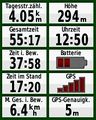
As planned, I left home earlier and arrived at a parking lot near Großalmerode around noon. Since I knew this area, I had planned one hour for the hike, knowing that it's going higher and higher on my way to the hash. So, I needed some 20 minutes for the 2 km to get near the hash. Now it were only another 65 meters off the main path and I started to do the hashdance... I was a little bit disorientated in this forest which was filled with zillions of smaller birch trees, but I managed to get to the hash location on another 'path', once made by wood harvesters whilst cutting wood here. Still this took me almost 15 minutes!
After taking the usual evidence I carefully got back out of the area and walked back the same way down to my car, where I arrived on schedule to get to work in time! I'm really enjoying the little thrill and walk through the woods, before going to work - it clears the mind and gives some sort of extra energy to manage that day ;-)
Photos
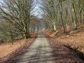
The way to the hash
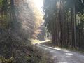
The way to the hash
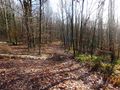
Getting closer
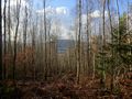
Another 35 meters down there
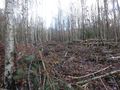
At the hash location
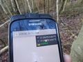
The hash - proof
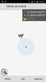
The hash - screenshot
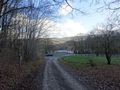
Getting back to my car
A nice little hike


