2018-12-24
From Geohashing
Revision as of 08:12, 17 December 2018 by imported>AperfectBot (Ook.)
Expedition Archives from December 2018
Sunday 23 December 2018 | Monday 24 December 2018 | Tuesday 25 December 2018
See also: Category:Meetup on 2018-12-24
Coordinates
West of -30°: .8639673, .5357197
East of -30°: .2298930, .5696816
Globalhash:
-48.619262285343,25.085388247474
Photo Gallery

Expeditions and Plans
| 2018-12-24 | ||
|---|---|---|
| La Pine, Oregon | Frogman, Benture, Daisy | Right in the middle of Forest Service Road 45, just west of Sunriver. |
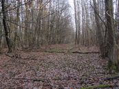
| Kassel, Germany | GeorgDerReisende | The hash lay inside of a small forest at Söhrewald-Wellerode. |