Difference between revisions of "2018-12-26 43 4"
imported>Niavlys (→Photos) |
imported>Niavlys (→Achievements: Achievements and categories) |
||
| Line 49: | Line 49: | ||
== Achievements == | == Achievements == | ||
{{#vardefine:ribbonwidth|800px}} | {{#vardefine:ribbonwidth|800px}} | ||
| − | |||
| − | + | {{Land geohash|latitude=43|longitude=4|date=2018-12-26|name=Niavlys}} | |
| − | + | {{Land geohash|latitude=43|longitude=4|date=2018-12-26|name=Fractal}} | |
| − | |||
| − | |||
| − | |||
| − | |||
| − | |||
| − | |||
| − | |||
| − | |||
| − | |||
| − | |||
| − | |||
[[Category:Expeditions]] | [[Category:Expeditions]] | ||
| − | |||
[[Category:Expeditions with photos]] | [[Category:Expeditions with photos]] | ||
| − | + | <!-- | |
[[Category:Expedition without GPS]] | [[Category:Expedition without GPS]] | ||
-- Tag your location: -- | -- Tag your location: -- | ||
{{location}} | {{location}} | ||
--> | --> | ||
| − | + | ||
| − | |||
[[Category:Coordinates reached]] | [[Category:Coordinates reached]] | ||
| − | |||
| − | |||
| − | |||
| − | |||
| − | |||
| − | |||
| − | |||
| − | |||
| − | |||
| − | |||
| − | |||
| − | |||
| − | |||
| − | |||
| − | |||
| − | |||
| − | |||
| − | |||
Revision as of 22:43, 28 December 2018
| Wed 26 Dec 2018 in 43,4: 43.7992945, 4.0032242 geohashing.info google osm bing/os kml crox |
Location
The hashpoint was easily accessible, in the middle of an unused portion of land without any trees, and with a path very close.
Participants
Expedition
The day after Christmas was a perfect occasion to experience geohashing with family. The point being only 6 kilometers away from where we live, three of us went by foot and two others by car and then by foot for the last kilometer. We left at 3.50pm, 1 hour 20 minutes before sunset, with Google Maps indicating about 1 hour 20 minutes to reach the point by foot.
The village nearby, Garrigues, is very pretty (and quiet, we caught almost nobody in the streets), as was the little cemetery outside, right on the way to our destination. At this cemetery, waiting for the two other members to arrive by car, we were able to experience the speed difference between sound and light, watching a man shoveling earth in his garden.
The hashpoint was very easy to reach, as expected, and we left a nice wooden sign. Nothing exceptional to see there, but we were quite glad to have an excuse to go outside and watch the sunset.
Photos
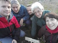
A picture of us at the hashpoint
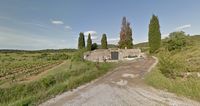
The cemetery outside Garrigues (capture from Google Street View)
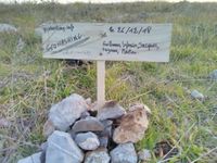
Blurry close-up on our wooden sign


Achievements
Niavlys earned the Land geohash achievement
|
Fractal earned the Land geohash achievement
|