2018-12-30 48 8
From Geohashing
Revision as of 14:35, 31 December 2018 by imported>Kellerkind (Created page with "{{meetup graticule | lat=48 | lon=8 | date=2018-12-30 }} __NOTOC__ == Location == Close to [https://de.wikipedia.org/wiki/Daxlanden Daxlanden]. == Participants == *User:...")
| Sun 30 Dec 2018 in 48,8: 48.9933206, 8.3097163 geohashing.info google osm bing/os kml crox |
Location
Close to Daxlanden.
Participants
- Kellerkind and his dad
Plans
After driving on a traffic training area (Verkehrsübungsplatz), my dad and I wanted to visit today's point.
Expedition
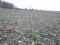
After leaving the traffic training area, we cycled to the point on a tandem. On the way there, we saw some weirdly named ways: literally just Weg Nr. 1 ("Path/street no. 1"), Weg Nr. 2 ("Path/street no. 2") and so on.. The geohash was on an open field, and we didn't even have to dirty our shoes this time! We left a little marker on the spot (see last picture).
Photos
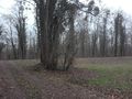
A tree ~40 m from the hash
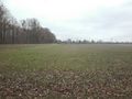
View towards the hash
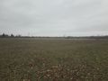
Another view
The point
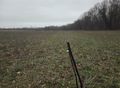
A stick we put in the ground
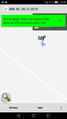
Geohash Droid screenshot


Achievements
This user earned the Land geohash achievement
|
This user earned the Bicycle geohash achievement
|