Difference between revisions of "2019-01-05 51 9"
imported>Digiphono (→Plans) |
imported>FippeBot m (Location) |
||
| (One intermediate revision by one other user not shown) | |||
| Line 1: | Line 1: | ||
| − | |||
| − | |||
| − | |||
| − | |||
| − | |||
| − | |||
| − | |||
| − | |||
| − | |||
| − | |||
{{meetup graticule | {{meetup graticule | ||
| lat=51 | | lat=51 | ||
| Line 15: | Line 5: | ||
}} | }} | ||
| − | |||
__NOTOC__ | __NOTOC__ | ||
== Location == | == Location == | ||
| − | |||
In a forest south from Hessisch Lichtenau. | In a forest south from Hessisch Lichtenau. | ||
== Participants == | == Participants == | ||
| − | |||
| − | |||
[[User:Digiphono|Digiphono]] | [[User:Digiphono|Digiphono]] | ||
== Plans == | == Plans == | ||
| − | |||
[[User:Digiphono|Digiphono]] wants to get there by car and do a little hike to arrive at the hash between 10:30 and 11:00 am. | [[User:Digiphono|Digiphono]] wants to get there by car and do a little hike to arrive at the hash between 10:30 and 11:00 am. | ||
== Expedition == | == Expedition == | ||
| − | |||
| − | + | The entire night was pretty restless, because I woke up several times due to the storm and heavy rain outside - oh man, not the best weather to get up early and go hashing! But, when I woke up, it had turned a little better, so I decided to drive to Hessisch Lichtenau and walk some 300 meters on a path to reach the hash - easy as that! | |
| − | |||
| − | + | But, after I parked my car, I noticed that one cannot always trust Google Maps or even Open Street Map - because: where's the path? OK, last year's heavy storms also left their mark on the forests in this area, but why didn't I recognize a path AT ALL??? A little bit confused I just started to walk into the direction where the hash should be, and after maybe 50 meters I finally found an older trail - which in fact turned out to be the one that's on the maps, but I had expected it to be way better! | |
| − | |||
| − | |||
| − | |||
| − | |||
| − | |||
| − | + | Anyway, after only five minutes I reached an open spot in the forest and the last 75 meters were easy to go. As I almost stumbled over a cadaver, I had a look at the app, and I was only 15 meters away from the hash. It was no problem to get the hash as accurate as less than 2 meters. I took the obligatory pics and walked back to my car again... That was enough rain and storm for today, but after exactly one month without any succesful expeditions, I drove back home satisfied! | |
| − | |||
| − | |||
| − | |||
| − | |||
| − | |||
| − | + | == Photos == | |
| − | <!-- | + | <gallery> |
| − | + | Image:2019-01-05_51_9_001.jpg | The 'way' to the hash? | |
| − | + | Image:2019-01-05_51_9_002.jpg | The 'better way' to the hash! | |
| − | --> | + | Image:2019-01-05_51_9_003.jpg | The way getting somewhat better |
| + | Image:2019-01-05_51_9_004.jpg | The final 150 meters to the hash | ||
| + | Image:2019-01-05_51_9_005.jpg | View from the hash location | ||
| + | Image:2019-01-05_51_9_006.jpg | I found this cadaver... | ||
| + | Image:2019-01-05_51_9_007.jpg | ...only 15 meters from the hash | ||
| + | Image:2019-01-05_51_9_008.jpg | The hash - proof | ||
| + | Image:2019-01-05_51_9_009.jpg | The hash - screenshot | ||
| + | Image:2019-01-05_51_9_010.jpg | The hasher | ||
| + | </gallery> | ||
| − | |||
| − | |||
| − | |||
[[Category:Expeditions]] | [[Category:Expeditions]] | ||
| − | |||
[[Category:Expeditions with photos]] | [[Category:Expeditions with photos]] | ||
| − | |||
| − | |||
| − | |||
| − | |||
| − | |||
| − | |||
| − | |||
[[Category:Coordinates reached]] | [[Category:Coordinates reached]] | ||
| − | + | {{location|DE|HE|WIZ}} | |
| − | |||
| − | |||
| − | |||
| − | |||
| − | |||
| − | |||
| − | |||
| − | |||
| − | |||
| − | |||
| − | |||
| − | |||
| − | |||
| − | |||
| − | |||
| − | |||
| − | |||
Latest revision as of 04:23, 16 August 2019
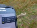
| Sat 5 Jan 2019 in 51,9: 51.1880157, 9.7033157 geohashing.info google osm bing/os kml crox |
Location
In a forest south from Hessisch Lichtenau.
Participants
Plans
Digiphono wants to get there by car and do a little hike to arrive at the hash between 10:30 and 11:00 am.
Expedition
The entire night was pretty restless, because I woke up several times due to the storm and heavy rain outside - oh man, not the best weather to get up early and go hashing! But, when I woke up, it had turned a little better, so I decided to drive to Hessisch Lichtenau and walk some 300 meters on a path to reach the hash - easy as that!
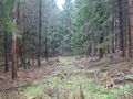
But, after I parked my car, I noticed that one cannot always trust Google Maps or even Open Street Map - because: where's the path? OK, last year's heavy storms also left their mark on the forests in this area, but why didn't I recognize a path AT ALL??? A little bit confused I just started to walk into the direction where the hash should be, and after maybe 50 meters I finally found an older trail - which in fact turned out to be the one that's on the maps, but I had expected it to be way better!
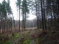
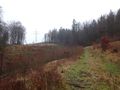
Anyway, after only five minutes I reached an open spot in the forest and the last 75 meters were easy to go. As I almost stumbled over a cadaver, I had a look at the app, and I was only 15 meters away from the hash. It was no problem to get the hash as accurate as less than 2 meters. I took the obligatory pics and walked back to my car again... That was enough rain and storm for today, but after exactly one month without any succesful expeditions, I drove back home satisfied!
Photos
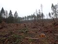
The 'way' to the hash?
The 'better way' to the hash!
The way getting somewhat better
The final 150 meters to the hash
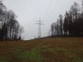
View from the hash location
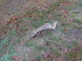
I found this cadaver...
...only 15 meters from the hash
The hash - proof

The hash - screenshot

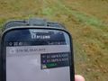
The hasher


