Difference between revisions of "2019-01-06 44 -88"
imported>WausauBill (→Expedition) |
m |
||
| (6 intermediate revisions by 2 users not shown) | |||
| Line 22: | Line 22: | ||
== Participants == | == Participants == | ||
| − | + | Yours truly, [[User:WausauBill|WausauBill]] ([[User talk:WausauBill|talk]]) and my favorite adventure sharer, Kathy. | |
== Plans == | == Plans == | ||
| − | Looking at this hash on Google maps, we knew it was going to present a number of unique challenges. It is quite far from our home location (one graticule to the east) and in a very unfamiliar environment. Fortunately, being a weekend we were able to our expedition in advance and gather the tools and supplies we would need for this difficult feat. | + | Looking at this hash on Google maps, we knew it was going to present a number of unique challenges. It is quite far from our home location (one graticule to the east) and in a very unfamiliar environment. Fortunately, being a weekend we were able to plan our expedition in advance and gather the tools and supplies we would need for this difficult feat. |
== Expedition == | == Expedition == | ||
| Line 49: | Line 49: | ||
Finally we were able to find sustenance at [https://www.alshamburgershop.com/ Al's,] a super retro hamburger joint and once again we could breathe easy. | Finally we were able to find sustenance at [https://www.alshamburgershop.com/ Al's,] a super retro hamburger joint and once again we could breathe easy. | ||
| − | |||
| − | |||
| − | |||
== Photos == | == Photos == | ||
| Line 60: | Line 57: | ||
Image:2019-01-06_44_-88_WausauBill_1546792344899.jpg|Green Bay, WI [http://www.openstreetmap.org/?lat=44.57311340&lon=-88.07934390&zoom=16&layers=B000FTF @44.5731,-88.0793] | Image:2019-01-06_44_-88_WausauBill_1546792344899.jpg|Green Bay, WI [http://www.openstreetmap.org/?lat=44.57311340&lon=-88.07934390&zoom=16&layers=B000FTF @44.5731,-88.0793] | ||
| − | |||
| − | + | Image:2019-01-06 44 -88 WausauBill Proof.png | Proof from inside the car! | |
| − | |||
| − | |||
| − | + | Image:2019-01-06 44 -88 WausauBill Pic1.jpg | The power substation is behind us! | |
| − | |||
| − | |||
| − | + | Image:2019-01-06 44 -88 WausauBill Pic2.jpg | Eat at Al's! | |
| − | + | Image:2019-01-06 44 -88 WausauBill Pic4.jpg | Lunch at Al's! | |
| − | + | </gallery> | |
| − | |||
| − | |||
| − | |||
| − | < | ||
| − | |||
[[Category:Expeditions]] | [[Category:Expeditions]] | ||
| − | |||
[[Category:Expeditions with photos]] | [[Category:Expeditions with photos]] | ||
| − | |||
| − | |||
| − | |||
| − | |||
| − | |||
| − | |||
| − | |||
[[Category:Coordinates reached]] | [[Category:Coordinates reached]] | ||
| − | + | {{location|US|WI|BW}} | |
| − | |||
| − | |||
| − | |||
| − | |||
| − | |||
| − | |||
| − | |||
| − | |||
| − | |||
| − | |||
| − | |||
| − | |||
| − | |||
| − | |||
| − | |||
| − | |||
| − | |||
Latest revision as of 13:25, 23 September 2021
| Sun 6 Jan 2019 in 44,-88: 44.5730534, -88.0792620 geohashing.info google osm bing/os kml crox |
Location
Green Bay, WI
Participants
Yours truly, WausauBill (talk) and my favorite adventure sharer, Kathy.
Plans
Looking at this hash on Google maps, we knew it was going to present a number of unique challenges. It is quite far from our home location (one graticule to the east) and in a very unfamiliar environment. Fortunately, being a weekend we were able to plan our expedition in advance and gather the tools and supplies we would need for this difficult feat.
Expedition
We knew this would be a challenge and the day did not disappoint.
It all started before I left when I realized that I had forgotten to get half and half the night before, so I would have to skip my morning coffee. But that is what happens when you wake up at 8:30 am to go adventuring.
Finally, after a delightful and lengthy warm shower, we were able to pool our resources and get on the road. First stop, Kwik Trip to get some coffee. Thank goodness they had half and half. The journey could begin.
After three quick turns we were on the street where the freeway entrance is. We turned left onto the freeway, which was free of both snow and any significant traffic and settled in for the grueling drive. Ugh...nothing but news of the government shut down, so we turned off NPR and fired up Spotify. I could only hope that we would not lose connectivity.
The smooth tarmac took us through a lovely rolling countryside that hid the dangers ahead. We only had our familiar playlist to sing along with to cut the tension.
Finally, after just over an hour of uneventful smooth and traffic free driving, we knew it was time to turn on Google maps to guide us to our final destination.
We exited off the freeway into a labyrinth of traffic circles, sometimes two in a row! Things got so bad that we missed our exit in one and had to backtrack an entire block (a whole block!) to get back on course. The residential homes glided by with their snow covered lawns and several excrutiating minutes later our destination was in sight.
The hash was on a small piece of land where a power substation is located, so there is driveway off the street. The substation is probably 50 meters or more from the hash, so is no problem. But as we pulled onto the flat, clear concrete driveway, we knew that we face, maybe 5 meter walk on inch and a half deep snow. We shuddered at the thought, but then from out of the blue, we were saved! The GPS on the phone said that we had, in fact reached the hash point -- without even leaving the car!
Our harrowing journey was over, we had arrived.
We took our pictures and screenshotted our proof. But our travails were not yet over. Coming out of the driveway back onto the street, once again, we turned the wrong way and had to retrace our steps for an ENTIRE BLOCK!
Finally we were able to find sustenance at Al's, a super retro hamburger joint and once again we could breathe easy.
Photos
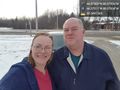
Green Bay, WI @44.5731,-88.0793
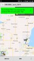
Proof from inside the car!
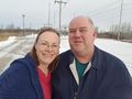
The power substation is behind us!
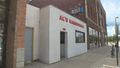
Eat at Al's!
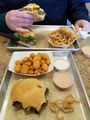
Lunch at Al's!


