Difference between revisions of "2019-01-09 61 23"
From Geohashing
(Created page with "{{meetup graticule | lat=61 | lon=23 | date=2019-01-09 }} <!-- edit as necessary --> __NOTOC__ == Location == Small residential area in Vesilahti, 4 km SE from municipality...") |
(Categories) |
||
| (3 intermediate revisions by one other user not shown) | |||
| Line 4: | Line 4: | ||
| date=2019-01-09 | | date=2019-01-09 | ||
}} | }} | ||
| − | |||
| − | |||
__NOTOC__ | __NOTOC__ | ||
| Line 22: | Line 20: | ||
== Photos == | == Photos == | ||
| − | |||
| − | |||
| − | |||
<gallery perrow="5"> | <gallery perrow="5"> | ||
Image:2019_01_09_61_23_Twins.jpg | Twins - tall spruces side by side | Image:2019_01_09_61_23_Twins.jpg | Twins - tall spruces side by side | ||
Image:2019_01_09_61_23_Hashpoint.jpg | View from hashpoint | Image:2019_01_09_61_23_Hashpoint.jpg | View from hashpoint | ||
| − | Image:2019_01_09_61_23_GPS | GPS and cellphone | + | Image:2019_01_09_61_23_GPS.jpg | GPS and cellphone |
| − | Image:2019_01_09_61_23_Satellite | Satellite image | + | Image:2019_01_09_61_23_Satellite.JPG | Satellite image |
</gallery> | </gallery> | ||
| − | |||
| − | |||
| − | |||
| − | |||
| − | |||
| − | |||
| − | |||
| − | |||
| − | |||
| − | |||
| − | |||
| − | |||
| − | |||
| − | |||
| − | |||
| − | |||
| − | |||
[[Category:Expeditions]] | [[Category:Expeditions]] | ||
[[Category:Expeditions with photos]] | [[Category:Expeditions with photos]] | ||
| − | |||
| − | |||
| − | |||
[[Category:Coordinates reached]] | [[Category:Coordinates reached]] | ||
| − | |||
| − | |||
| − | |||
| − | |||
| − | |||
| − | |||
| − | |||
| − | |||
| − | |||
| − | |||
| − | |||
| − | |||
| − | |||
| − | |||
| − | |||
| − | |||
{{location|FI|11}} | {{location|FI|11}} | ||
Latest revision as of 17:16, 24 May 2020
| Wed 9 Jan 2019 in 61,23: 61.2827813, 23.6968347 geohashing.info google osm bing/os kml crox |
Location
Small residential area in Vesilahti, 4 km SE from municipality center and 24 km south from Tampere.
Participants
PJH FIN (talk)
Hermiina (talk)
Plans
This was quite an extempore decision, suggested by Hermiina. Winter time can be difficult for expeditions, but not at this location.
Expedition
The day was already darkening when we reached hashpoint. We did not want to spend any extra time there because of nearby houses. Amount of snow was quite normal on January in southern Finland.
Photos
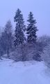
Twins - tall spruces side by side
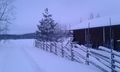
View from hashpoint
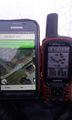
GPS and cellphone
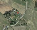
Satellite image


