Difference between revisions of "2019-01-10 51 9"
imported>Digiphono (Created page with "{{subst:Expedition |lat = 51 |lon = 9 |date = 2018-01-10 }}") |
imported>FippeBot m (Location) |
||
| (7 intermediate revisions by 2 users not shown) | |||
| Line 1: | Line 1: | ||
| − | |||
| − | |||
| − | |||
| − | |||
| − | |||
| − | |||
| − | |||
| − | |||
| − | |||
| − | |||
{{meetup graticule | {{meetup graticule | ||
| lat=51 | | lat=51 | ||
| lon=9 | | lon=9 | ||
| − | | date= | + | | date=2019-01-10 |
}} | }} | ||
| − | |||
__NOTOC__ | __NOTOC__ | ||
== Location == | == Location == | ||
| − | + | ||
| + | In a forest south east of Eiterhagen. | ||
== Participants == | == Participants == | ||
| − | + | ||
| − | + | [[User:Digiphono|Digiphono]] | |
== Plans == | == Plans == | ||
| − | + | ||
| + | If it isn't snowing too much, [[User:Digiphono|Digiphono]] will drive to Eiterhagen after work, to arrive there at around 2:30 pm. | ||
== Expedition == | == Expedition == | ||
| − | |||
| − | + | Since it didn't snow today and all the roads were free, I decided to drive to this hash right after work. After a 25 minute drive, I arrived in Eiterhagen 2:20 pm and parked my car at the end of a street, leading directly into the forest. The way to the hash was only 800 meters, pretty steep at the beginning, but this was ok. There was some snow from yesterday and temperatures were little below zero, which would've honoured me the frozen achievement I guess, but the thermometer in my car said it were exactly 0 degrees, so I don't have any proof and have to wait a little bit longer for the frozen achievement hehe... | |
| − | + | ||
| + | I took some pics on the hash location, enjoyed the view on Eiterhagen from there and then walked back to my car and searched and found one geocache only 50 meters away. After half an hour I was finished and drove back home again... | ||
== Photos == | == Photos == | ||
| − | < | + | |
| − | Image: | + | <gallery> |
| − | -- | + | Image:2019-01-10_51_9_001.jpg | The way to the hash |
| − | + | Image:2019-01-10_51_9_002.jpg | Almost there... | |
| + | Image:2019-01-10_51_9_003.jpg | The hash was at this tree | ||
| + | Image:2019-01-10_51_9_004.jpg | The hash - proof | ||
| + | Image:2019-01-10_51_9_005.jpg | The hash - screenshot | ||
| + | Image:2019-01-10_51_9_006.jpg | View on Eiterhagen from the hash | ||
| + | Image:2019-01-10_51_9_007.jpg | The hasher | ||
| + | Image:2019-01-10_51_9_008.jpg | Footprints | ||
</gallery> | </gallery> | ||
| − | |||
| − | |||
| − | |||
| − | |||
| − | |||
| − | |||
| − | |||
| − | |||
| − | |||
| − | |||
| − | |||
| − | |||
| − | |||
| − | |||
| − | |||
| − | |||
| − | |||
| − | |||
[[Category:Expeditions]] | [[Category:Expeditions]] | ||
| − | |||
[[Category:Expeditions with photos]] | [[Category:Expeditions with photos]] | ||
| − | |||
| − | |||
| − | |||
| − | |||
| − | |||
| − | |||
| − | |||
[[Category:Coordinates reached]] | [[Category:Coordinates reached]] | ||
| − | + | {{location|DE|HE|KS}} | |
| − | |||
| − | |||
| − | |||
| − | |||
| − | |||
| − | |||
| − | |||
| − | |||
| − | |||
| − | |||
| − | |||
| − | |||
| − | |||
| − | |||
| − | |||
| − | |||
| − | |||
Latest revision as of 03:29, 7 August 2019
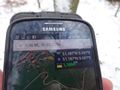
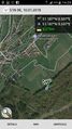
| Thu 10 Jan 2019 in 51,9: 51.1871731, 9.5969879 geohashing.info google osm bing/os kml crox |
Location
In a forest south east of Eiterhagen.
Participants
Plans
If it isn't snowing too much, Digiphono will drive to Eiterhagen after work, to arrive there at around 2:30 pm.
Expedition
Since it didn't snow today and all the roads were free, I decided to drive to this hash right after work. After a 25 minute drive, I arrived in Eiterhagen 2:20 pm and parked my car at the end of a street, leading directly into the forest. The way to the hash was only 800 meters, pretty steep at the beginning, but this was ok. There was some snow from yesterday and temperatures were little below zero, which would've honoured me the frozen achievement I guess, but the thermometer in my car said it were exactly 0 degrees, so I don't have any proof and have to wait a little bit longer for the frozen achievement hehe...
I took some pics on the hash location, enjoyed the view on Eiterhagen from there and then walked back to my car and searched and found one geocache only 50 meters away. After half an hour I was finished and drove back home again...
Photos
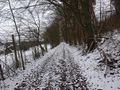
The way to the hash
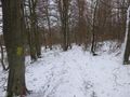
Almost there...
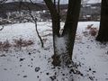
The hash was at this tree
The hash - proof
The hash - screenshot
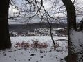
View on Eiterhagen from the hash

The hasher
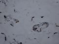
Footprints


