Difference between revisions of "2019-01-13 59 17"
imported>Fractal |
imported>FippeBot m (Location) |
||
| (2 intermediate revisions by one other user not shown) | |||
| Line 4: | Line 4: | ||
| date=2019-01-13 | | date=2019-01-13 | ||
}} | }} | ||
| − | |||
<!-- edit as necessary --> | <!-- edit as necessary --> | ||
__NOTOC__ | __NOTOC__ | ||
| Line 18: | Line 17: | ||
== Expedition == | == Expedition == | ||
| − | + | I left from my house at about 9am. It was quite sunny, despite the weather forecast telling me that it shouldn’t be, but somewhat cold though. But I did buy warm socks the day before and I had some kind on ski pants on me, so it was good. I first took a bus, then two subways, then another bus to get as close as possible to the hashpoint. After that I followed the main road on foot for about half an hour, until I reached the frozen field in which the hashpoint was located, and reaching the hashpoint wasn’t difficult. | |
| + | |||
| + | To go back to the bus stop I decided to take a different road because the main road was not really pedestrian-friendly, so I went through the village of Skå. It was very nice and quiet, Skå is a small rural village with only a school, a church, and a few houses, and the only commercial activity in Skå seems to be an "animal massage" place (presumably for horses, given the smell). | ||
| + | |||
| + | As the hashpoint itself wasn’t in an especially interesting location, I decided to combine this expedition with some more walking. After researching online I decided to walk all around the island of Kärsön, on the way back to Stockholm. It’s an island consisting mainly of a big forest surrounded by a lake and seemed to be a popular walk. And it was indeed very nice and quite a few other people decided to do this walk as well. | ||
== Photos == | == Photos == | ||
| − | < | + | <gallery perrow="5" widths=250px heights=250px> |
| − | Image: | + | Image:2019-01-13_59_17-2.jpg | The frozen field where the hashpoint was |
| − | -- | + | Image:2019-01-13_59_17-3.jpg | Me at the hashpoint |
| − | + | Image:2019-01-13_59_17-4.png | Proof | |
| + | Image:2019-01-13_59_17-1.jpg | Skå’s church | ||
</gallery> | </gallery> | ||
| − | |||
| − | |||
| − | |||
| − | |||
| − | |||
| − | |||
| − | |||
| − | |||
| − | |||
| − | |||
| − | |||
[[Category:Expeditions]] | [[Category:Expeditions]] | ||
| − | |||
[[Category:Expeditions with photos]] | [[Category:Expeditions with photos]] | ||
| − | |||
| − | |||
| − | |||
| − | |||
| − | |||
| − | |||
| − | |||
[[Category:Coordinates reached]] | [[Category:Coordinates reached]] | ||
| − | + | {{location|SE|AB}} | |
| − | |||
| − | |||
| − | |||
| − | |||
| − | |||
| − | |||
| − | |||
| − | |||
| − | |||
| − | |||
| − | |||
| − | |||
| − | |||
| − | |||
| − | |||
| − | |||
| − | |||
Latest revision as of 04:25, 16 August 2019
| Sun 13 Jan 2019 in 59,17: 59.3357663, 17.7325885 geohashing.info google osm bing/os kml crox |
Location
In a field on an island west of Stockholm.
Participants
Plans
Im planning to get there in the morning.
Expedition
I left from my house at about 9am. It was quite sunny, despite the weather forecast telling me that it shouldn’t be, but somewhat cold though. But I did buy warm socks the day before and I had some kind on ski pants on me, so it was good. I first took a bus, then two subways, then another bus to get as close as possible to the hashpoint. After that I followed the main road on foot for about half an hour, until I reached the frozen field in which the hashpoint was located, and reaching the hashpoint wasn’t difficult.
To go back to the bus stop I decided to take a different road because the main road was not really pedestrian-friendly, so I went through the village of Skå. It was very nice and quiet, Skå is a small rural village with only a school, a church, and a few houses, and the only commercial activity in Skå seems to be an "animal massage" place (presumably for horses, given the smell).
As the hashpoint itself wasn’t in an especially interesting location, I decided to combine this expedition with some more walking. After researching online I decided to walk all around the island of Kärsön, on the way back to Stockholm. It’s an island consisting mainly of a big forest surrounded by a lake and seemed to be a popular walk. And it was indeed very nice and quite a few other people decided to do this walk as well.
Photos
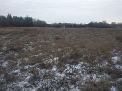
The frozen field where the hashpoint was
- Error creating thumbnail: Unable to save thumbnail to destination
Me at the hashpoint
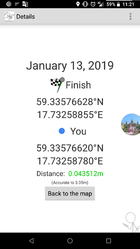
Proof
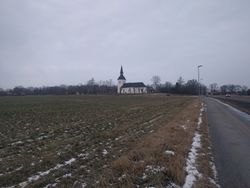
Skå’s church


