Difference between revisions of "2019-01-19 -12 -77"
(Page created) |
(Add expedition story) |
||
| Line 1: | Line 1: | ||
| − | + | {{meetup graticule | |
| − | |||
| − | |||
| − | |||
| − | |||
| − | |||
| − | |||
| − | |||
| − | |||
| lat={{#explode:{{SUBPAGENAME}}| |1}} | | lat={{#explode:{{SUBPAGENAME}}| |1}} | ||
| lon={{#explode:{{SUBPAGENAME}}| |2}} | | lon={{#explode:{{SUBPAGENAME}}| |2}} | ||
| date={{#explode:{{SUBPAGENAME}}| |0}} | | date={{#explode:{{SUBPAGENAME}}| |0}} | ||
| − | }} | + | }} |
__NOTOC__ | __NOTOC__ | ||
== Location == | == Location == | ||
| − | + | Close to a highway around 2.5 km from the airport. | |
== Participants == | == Participants == | ||
| − | + | * [[User:Pah|pah]] [[File:U+110DB.png|middle|6px|link=User:Pah]] ([[1977-10-19 48 11|prev]]|next) | |
| − | -- | ||
| − | == | + | == Expedition == |
| − | |||
| − | = | + | After a three weeks round trip through Peru, Bolivia, and Chile with a tight schedule and little network reception and therefore no opportunities to visit any hashes, [[User:Pah|pah]] [[File:U+110DB.png|middle|6px|link=User:Pah]] went to the Lima airport in the morning of 2019-01-19 to travel back to Germany via Rio de Janeiro. Once he passed security and immigration, he waited for boarding and logged into the interwebs, where it suddenly struck him: Today’s hash for ([[-12,-77]]) '''was just 2.5km away'''! |
| − | + | ||
| + | He got very sad, that he had '''no chance''' of provably getting there, as his flight was scheduled in less than 90 minutes and he was already stuck in the security area of the airport. Why didn’t he get up two hours sooner?! | ||
| + | |||
| + | During take-off, he desperately tried to convince his GPS to lock-in a closer distance to the hash point - direction was right and the plane to Rio even did a westwards turn right after the start. So there might be a minuscule chance that he actually passed over the hash and then would’ve even earned an [[Air geohash achievement]], deflowered the [[Virgin Graticule]] ([[-12,-77]]), and finally checked the second continent of the [[Globetrotters Geohash]], but there was no luck in using the GPS from inside the plane. | ||
| − | + | Even the [[Curse of Unawareness|Curse of Unawareness Consolation Prize]] cannot spend some relief to pah’s broken heart, as it requires to actually reach the cordinates. There really [[Achievements#.22There_Should_Be_a_Ribbon_for_This.22_Category|should be a ribbon for this]] very unlucky story! | |
| − | |||
== Photos == | == Photos == | ||
| − | + | ||
| − | |||
| − | |||
<gallery perrow="5"> | <gallery perrow="5"> | ||
| + | Image:2019-01-19 -12 -77 pah 001.png | So close and yet out of reach :-( | ||
</gallery> | </gallery> | ||
== Achievements == | == Achievements == | ||
{{#vardefine:ribbonwidth|800px}} | {{#vardefine:ribbonwidth|800px}} | ||
| − | |||
| − | + | {{Radio Yerevan | |
| − | + | | achievement = [[Curse of Unawareness|Curse of Unawareness Consolation Prize]] | |
| + | | detail = he (very likely) didn’t make it to the hash, as he became aware of its location too late | ||
| + | | date = 2019-01-19 | ||
| + | | latitude = -12 | ||
| + | | longitude = -77 | ||
| + | | user = [[User:Pah|pah]] [[File:U+110DB.png|middle|6px|link=User:Pah]] | ||
| + | }} | ||
| + | |||
[[Category:New report]] | [[Category:New report]] | ||
| − | |||
| − | |||
| − | |||
| − | |||
| − | |||
| − | |||
| − | |||
| − | |||
| − | |||
| − | |||
| − | |||
[[Category:Expeditions]] | [[Category:Expeditions]] | ||
| − | |||
| − | |||
| − | |||
| − | |||
| − | |||
| − | |||
| − | |||
| − | |||
| − | |||
| − | |||
| − | |||
[[Category:Coordinates not reached]] | [[Category:Coordinates not reached]] | ||
| − | + | [[Category:Not reached - Time constraints]] | |
| − | |||
| − | |||
| − | |||
| − | |||
| − | |||
| − | |||
| − | |||
| − | [[Category:Not reached - | ||
| − | |||
| − | |||
| − | |||
| − | |||
| − | |||
Revision as of 11:33, 12 July 2020
| Sat 19 Jan 2019 in -12,-77: -12.0080221, -77.1268286 geohashing.info google osm bing/os kml crox |
Location
Close to a highway around 2.5 km from the airport.
Participants
Expedition
After a three weeks round trip through Peru, Bolivia, and Chile with a tight schedule and little network reception and therefore no opportunities to visit any hashes, pah ![]() went to the Lima airport in the morning of 2019-01-19 to travel back to Germany via Rio de Janeiro. Once he passed security and immigration, he waited for boarding and logged into the interwebs, where it suddenly struck him: Today’s hash for (-12,-77) was just 2.5km away!
went to the Lima airport in the morning of 2019-01-19 to travel back to Germany via Rio de Janeiro. Once he passed security and immigration, he waited for boarding and logged into the interwebs, where it suddenly struck him: Today’s hash for (-12,-77) was just 2.5km away!
He got very sad, that he had no chance of provably getting there, as his flight was scheduled in less than 90 minutes and he was already stuck in the security area of the airport. Why didn’t he get up two hours sooner?!
During take-off, he desperately tried to convince his GPS to lock-in a closer distance to the hash point - direction was right and the plane to Rio even did a westwards turn right after the start. So there might be a minuscule chance that he actually passed over the hash and then would’ve even earned an Air geohash achievement, deflowered the Virgin Graticule (-12,-77), and finally checked the second continent of the Globetrotters Geohash, but there was no luck in using the GPS from inside the plane.
Even the Curse of Unawareness Consolation Prize cannot spend some relief to pah’s broken heart, as it requires to actually reach the cordinates. There really should be a ribbon for this very unlucky story!
Photos
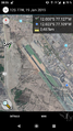
So close and yet out of reach :-(

Achievements
Is it true that pah
|