Difference between revisions of "2019-01-26 42 -85"
imported>Mcbaneg (Created page with "{{meetup graticule | lat=42 | lon=-85 | date=2019-01-26 }} <!-- edit as necessary --> __NOTOC__ == Location == woods on Spartan Industrial Drive between Hascall Steel and Wo...") |
imported>Mcbaneg |
||
| Line 19: | Line 19: | ||
It will be cold and there will be snow on the ground. | It will be cold and there will be snow on the ground. | ||
| + | == Expedition == | ||
| + | More or less as expected. I had to walk down a brushy bank for several meters before reaching the flat floor of a little swale. Sparse underbrush and the occasional tree were sticking up through the snow but the way was quite clear. I was quickly within a few meters of the hashpoint. As I wandered around trying to get closer, I distinctly heard and felt the cracking of a big sheet of ice underfoot. Uh-oh; was I walking on a recently-frozen pond? It couldn't be too deep since ordinary woody plants were growing out of it. I proceeded gingerly, wincing when I heard cracks. The sheets that seemed to be breaking were something like a meter across, though I couldn't see the ice itself because of the snow cover. | ||
| + | |||
| + | The GPS tended to lose lock under the trees, and at one point I retreated to the bank because it was claiming I was more than 100m from the hashpoint. Going back to the road cleared its mind and demonstrated I had been in the right place after all, and I returned to the hashpoint to continue the dance. | ||
| + | |||
| + | I actually wondered whether I might be earning a [http://wiki.xkcd.com/geohashing/Walking_on_water_geohash_achievement| Walking on water achievement] but the rules there indicate that if you could have waded to the hashpoint you haven't earned it. I don't actually know whether there was liquid water under the ice I was walking on, but if there was it was probably only a few mm deep. More likely I was walking on weak ice over mud. | ||
<!-- Insert pictures between the gallery tags using the following format: | <!-- Insert pictures between the gallery tags using the following format: | ||
Image:2012-##-## ## ## Alpha.jpg | Witty Comment | Image:2012-##-## ## ## Alpha.jpg | Witty Comment | ||
| − | + | --> | |
<gallery perrow="4"> | <gallery perrow="4"> | ||
| − | Image:2019-01- | + | Image:2019-01-26_42_-85_016.png | Proof |
| − | Image:2019-01- | + | Image:2019-01-26_42_-85_007.jpg | Grin |
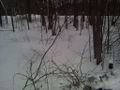
| − | Image:2019-01- | + | Image:2019-01-26_42_-85_010.jpg | Hashdance tracks |
| − | Image:2019-01- | + | Image:2019-01-26_42_-85_008.jpg | view N from hashpoint toward self-storage units |
| − | Image:2019-01- | + | Image:2019-01-26_42_-85_017.jpg | view NE toward hashpoint from roadbank |
| + | Image:2019-01-26_42_-85_temp.png | Temperature record from Timberlane Pond station, KMIWYOMI15, just NE of hashpoint at 42.892 -85.734 | ||
</gallery> | </gallery> | ||
| − | + | ||
| − | + | ||
== Achievements == | == Achievements == | ||
| Line 39: | Line 46: | ||
| latitude = 42 | | latitude = 42 | ||
| longitude =-85 | | longitude =-85 | ||
| − | | date =2019-01- | + | | date =2019-01-26 |
| − | | temperature = | + | | temperature = 17 °F |
| name = [[User:Mcbaneg|Mcbaneg]] (George) | | name = [[User:Mcbaneg|Mcbaneg]] (George) | ||
}} | }} | ||
| − | + | ||
<!-- =============== USEFUL CATEGORIES FOLLOW ================ | <!-- =============== USEFUL CATEGORIES FOLLOW ================ | ||
<!-- Potential categories. Please include all the ones appropriate to your expedition --> | <!-- Potential categories. Please include all the ones appropriate to your expedition --> | ||
| − | [[Category: | + | [[Category:Expeditions]] |
| − | |||
[[Category:Expeditions with photos]] | [[Category:Expeditions with photos]] | ||
[[Category:Coordinates reached]] | [[Category:Coordinates reached]] | ||
| − | |||
Revision as of 00:32, 27 January 2019
| Sat 26 Jan 2019 in 42,-85: 42.8903382, -85.7362038 geohashing.info google osm bing/os kml crox |
Location
woods on Spartan Industrial Drive between Hascall Steel and Woodale Self Storage, north of 44th St., Grandville, MI, USA
Participants
Plans
This looks easily accessible. I will try coming by tomorrow after I finish interviewing students on campus. I expect to be there around 4 pm or slightly before.
It will be cold and there will be snow on the ground.
Expedition
More or less as expected. I had to walk down a brushy bank for several meters before reaching the flat floor of a little swale. Sparse underbrush and the occasional tree were sticking up through the snow but the way was quite clear. I was quickly within a few meters of the hashpoint. As I wandered around trying to get closer, I distinctly heard and felt the cracking of a big sheet of ice underfoot. Uh-oh; was I walking on a recently-frozen pond? It couldn't be too deep since ordinary woody plants were growing out of it. I proceeded gingerly, wincing when I heard cracks. The sheets that seemed to be breaking were something like a meter across, though I couldn't see the ice itself because of the snow cover.
The GPS tended to lose lock under the trees, and at one point I retreated to the bank because it was claiming I was more than 100m from the hashpoint. Going back to the road cleared its mind and demonstrated I had been in the right place after all, and I returned to the hashpoint to continue the dance.
I actually wondered whether I might be earning a Walking on water achievement but the rules there indicate that if you could have waded to the hashpoint you haven't earned it. I don't actually know whether there was liquid water under the ice I was walking on, but if there was it was probably only a few mm deep. More likely I was walking on weak ice over mud.
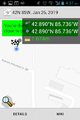
Proof

Grin
- Error creating thumbnail: Unable to save thumbnail to destination
Hashdance tracks
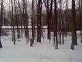
view N from hashpoint toward self-storage units
view NE toward hashpoint from roadbank
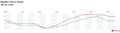
Temperature record from Timberlane Pond station, KMIWYOMI15, just NE of hashpoint at 42.892 -85.734


Achievements
