Difference between revisions of "2019-01-26 60 22"
(Created page with "{{meetup graticule | lat=60 | lon=22 | date=2019-01-26 }} __NOTOC__ == Location == Thick forest 1.5 km north of Oripää Airfield (EFOP), Finland. == Participants == User...") |
m |
||
| Line 25: | Line 25: | ||
== Photos == | == Photos == | ||
<gallery perrow="4"> | <gallery perrow="4"> | ||
| − | Image: | + | Image:2019 01 26 Reflections.jpg | Reflections |
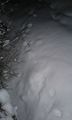
Image:2019_01_26_Snow.jpg | Deep snow | Image:2019_01_26_Snow.jpg | Deep snow | ||
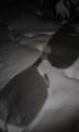
Image:2019_01_26_More_snow.jpg | Still more snow | Image:2019_01_26_More_snow.jpg | Still more snow | ||
Revision as of 11:08, 8 June 2020
| Sat 26 Jan 2019 in 60,22: 60.8903382, 22.7362038 geohashing.info google osm bing/os kml crox |
Location
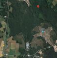
Thick forest 1.5 km north of Oripää Airfield (EFOP), Finland.
Participants
PJH FIN (talk)
Hermiina (talk)
Plans
We were once again travelling from Lempäälä to Turku region with Hermiina. Despite of early darkness and snow we decided to try Oripää hashpoint today.
Our direct line point-to-point distance would be 119 km and surprisingly the hashpoint almost lies on that line. Only 600 m off, as you can see in the last picture. But because we do not have a helicopter, we have to use roads, which increases the distance.
Expedition
30 km south of Huittinen we left highway 41 and turned to smaller roads.
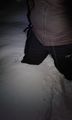
Total walking distance was only 425 m, but it was slow and hard. Road (or track) was slippery and in poor condition. Forest was quiet and full of snow and there was totally dark. Exciting atmosphere!
Photos
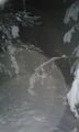
Reflections
Deep snow
Still more snow
Giant's sunglasses?

GPS and cellphone
Satellite image
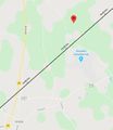
Hashpoint and 119 km direct line from our origin to destination


