Difference between revisions of "2019-02-14 50 8"
From Geohashing
imported>GeorgDerReisende (planning an expedition) |
imported>GeorgDerReisende (expedition report for Linden-Leihgestern) |
||
| (One intermediate revision by the same user not shown) | |||
| Line 1: | Line 1: | ||
| − | |||
| − | |||
| − | |||
| − | |||
| − | |||
| − | |||
| − | |||
| − | |||
| − | |||
| − | |||
{{meetup graticule | {{meetup graticule | ||
| lat=50 | | lat=50 | ||
| Line 19: | Line 9: | ||
== Location == | == Location == | ||
| − | + | ||
| + | The hash lies near Linden-Leihgestern, in the Steinweg, near the Phenological Garden | ||
== Participants == | == Participants == | ||
| − | + | ||
| − | + | [[User:GeorgDerReisende|GeorgDerReisende]] | |
== Plans == | == Plans == | ||
| − | + | ||
| + | I am traveling by public transport, arriving there at 2 pm. | ||
== Expedition == | == Expedition == | ||
| − | |||
| − | + | The journey went as planned, and I arrived at the hash at 14:05. The hash lay 0.5 meters on the grass. I wrote a note onto the board. | |
| − | |||
== Photos == | == Photos == | ||
| − | |||
| − | |||
| − | |||
<gallery perrow="5"> | <gallery perrow="5"> | ||
| + | 2019-02-14 50 8 GeorgDerReisende 8101.jpg | proof | ||
| + | 2019-02-14 50 8 GeorgDerReisende 8102.jpg | better view to the hash | ||
| + | 2019-02-14 50 8 GeorgDerReisende 8103.jpg | looking north | ||
| + | 2019-02-14 50 8 GeorgDerReisende 8104.jpg | east | ||
| + | 2019-02-14 50 8 GeorgDerReisende 8105.jpg | south | ||
| + | 2019-02-14 50 8 GeorgDerReisende 8106.jpg | west | ||
| + | 2019-02-14 50 8 GeorgDerReisende 8112.jpg | a notice | ||
| + | 2019-02-14 50 8 GeorgDerReisende 8118.jpg | looking from the north | ||
</gallery> | </gallery> | ||
== Achievements == | == Achievements == | ||
| + | |||
{{#vardefine:ribbonwidth|800px}} | {{#vardefine:ribbonwidth|800px}} | ||
| − | |||
| − | + | {{A Tale of Two Hashes challenge | latitude = 50 | longitude = 8 | date = 2019-02-14 | name = GeorgDerReisende | place = Linden }} | |
| − | |||
| − | |||
| − | + | [[Category:Expeditions]] | |
| − | + | [[Category:Expeditions with photos]] | |
| − | |||
| − | [[Category: | ||
| − | |||
| − | + | {{location|DE|HE|GI}} | |
| − | |||
| − | |||
| − | |||
| − | |||
| − | |||
| − | |||
| − | |||
| − | |||
| − | |||
| − | |||
| − | |||
[[Category:Coordinates reached]] | [[Category:Coordinates reached]] | ||
| − | |||
| − | |||
| − | |||
| − | |||
| − | |||
| − | |||
| − | |||
| − | |||
| − | |||
| − | |||
| − | |||
| − | |||
| − | |||
| − | |||
| − | |||
| − | |||
| − | |||
| − | |||
Latest revision as of 21:21, 14 February 2019
| Thu 14 Feb 2019 in 50,8: 50.5325218, 8.6841292 geohashing.info google osm bing/os kml crox |
Location
The hash lies near Linden-Leihgestern, in the Steinweg, near the Phenological Garden
Participants
Plans
I am traveling by public transport, arriving there at 2 pm.
Expedition
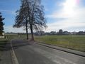
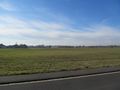
The journey went as planned, and I arrived at the hash at 14:05. The hash lay 0.5 meters on the grass. I wrote a note onto the board.
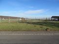
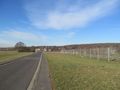
Photos
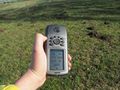
proof
better view to the hash
looking north
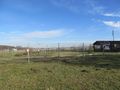
east
south
west
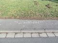
a notice
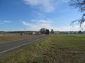
looking from the north


Achievements

GeorgDerReisende issued a challenge for the Tale of Two Hashes achievement
by geohashing in a place named Linden from the (50, 8) geohash on 2019-02-14.