Difference between revisions of "2019-02-18 53 9"
From Geohashing
Gumbledalf (talk | contribs) |
(→Photos: 14 of 91) |
||
| (One intermediate revision by one other user not shown) | |||
| Line 6: | Line 6: | ||
==Participants== | ==Participants== | ||
*[[User:Leidenfrost|Leidenfrost]] ([[User talk:Leidenfrost|talk]]) | *[[User:Leidenfrost|Leidenfrost]] ([[User talk:Leidenfrost|talk]]) | ||
| − | *[[User:π π π|π π π]] ([[User talk: | + | *[[User:π π π|π π π]] ([[User talk:π π π|talk]]) |
==Expedition== | ==Expedition== | ||
| Line 13: | Line 13: | ||
==Photos== | ==Photos== | ||
| − | + | <gallery> | |
| − | <gallery | + | File:2019-02-18 53 9 1.png | proof 1 |
| + | File:2019-02-18 53 9 2.png | proof 2 | ||
| + | File:2019-02-18 53 9 4.jpg | π π π | ||
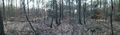
| + | File:2019-02-18 53 9 5.jpg | pano 1 | ||
| + | File:2019-02-18 53 9 6.jpg | pano 2 | ||
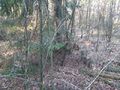
| + | File:2019-02-18 53 9 7.jpg | hash might've also been over there | ||
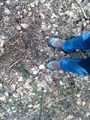
| + | File:2019-02-18 53 9 8.jpg | the hash | ||
</gallery> | </gallery> | ||
Latest revision as of 11:57, 15 May 2021
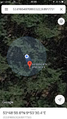
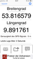
| Mon 18 Feb 2019 in 53,9: 53.8165497, 9.8917731 geohashing.info google osm bing/os kml crox |
Location
near a swale in a forest in Kaltenkirchen, Schleswig-Holstein
Participants
- Leidenfrost (talk)
- π π π (talk)
Expedition
π π π (log from April 2020)
In the afternoon, Leidenfrost and I cycled 8 km to our first forest geohash (there isn't much forest here). We had to walk the last 130 m on foot, but there was a small path which lead directly to the hash. We had to walk around a lot to find the right spot, which was next to a small swale. Then we rode back.
Photos
proof 1
proof 2
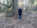
π π π
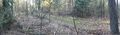
pano 1
pano 2
hash might've also been over there
the hash


Achievements
Land geohash, Bicycle geohash