Difference between revisions of "2019-03-21 52 4"
imported>FelixTheCat (Created page with "{{subst:Expedition |lat = 52 |lon = 4 |date = 2019-03-21 }}") |
imported>FippeBot m (Location) |
||
| (2 intermediate revisions by one other user not shown) | |||
| Line 1: | Line 1: | ||
| − | |||
| − | |||
| − | |||
| − | |||
| − | |||
| − | |||
| − | |||
| − | |||
| − | |||
| − | |||
{{meetup graticule | {{meetup graticule | ||
| lat=52 | | lat=52 | ||
| Line 14: | Line 4: | ||
| date=2019-03-21 | | date=2019-03-21 | ||
}} | }} | ||
| − | |||
| − | |||
__NOTOC__ | __NOTOC__ | ||
== Location == | == Location == | ||
| − | + | A park in Alkmaar, North Holland province, Netherlands. | |
== Participants == | == Participants == | ||
| − | + | [[User:FelixTheCat|FelixTheCat]] ([[User talk:FelixTheCat|talk]]) | |
| − | |||
| − | |||
| − | |||
| − | |||
== Expedition == | == Expedition == | ||
| − | + | Today's hash was located in a park in the old city of Alkmaar. This park was less than 500 metres from the train station, so I decided to travel there by train after work. I first took the Amsterdam Metro to Sloterdijk train station, then got on the Intercity service to Alkmaar. All of this took about 45 minutes. Once in Alkmaar I walked to the park, which was quite a nice place, but completely deserted on a grey weekday evening around dinner time. The hash was right next to a kind of teepee-like structure made from branches. I took a few pictures and then went back to the train station. The ride back home took about an hour and a half, mainly because there are not many fast trains in this semi-rural part of the country. | |
| − | |||
| − | |||
| − | |||
== Photos == | == Photos == | ||
| − | |||
| − | |||
| − | |||
<gallery perrow="5"> | <gallery perrow="5"> | ||
| + | Image:2019-03-21 52 4 FelixTheCat 1.JPG | Arriving at Sloterdijk station. | ||
| + | Image:2019-03-21 52 4 FelixTheCat 2.JPG | Arriving at Alkmaar. | ||
| + | Image:2019-03-21 52 4 FelixTheCat 3.JPG | A very typical Dutch scene with a windmill draining a polder. | ||
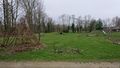
| + | Image:2019-03-21 52 4 FelixTheCat 4.JPG | The park, with a football pitch, a small amphitheatre and much more. The hash is behind all this. | ||
| + | Image:2019-03-21 52 4 FelixTheCat 5.JPG | The far end of the park, with wooden contraptions for climbing on and what looks like a hobbit house right in front. | ||
| + | Image:2019-03-21 52 4 FelixTheCat 8.JPG | The tent-like structure with the hash in front. | ||
| + | Image:2019-03-21 52 4 FelixTheCat 6.png | Reached it! | ||
| + | Image:2019-03-21 52 4 FelixTheCat 7.JPG | Lloyd celebrating. | ||
| + | Image:2019-03-21 52 4 FelixTheCat 9.JPG | Another view of the park, with spring flowers. | ||
| + | Image:2019-03-21 52 4 FelixTheCat 10.JPG | The first of three trains to get me back home. | ||
</gallery> | </gallery> | ||
== Achievements == | == Achievements == | ||
{{#vardefine:ribbonwidth|800px}} | {{#vardefine:ribbonwidth|800px}} | ||
| − | + | {{Public transport geohash | |
| − | + | | latitude = 52 | |
| − | + | | longitude = 4 | |
| − | + | | date = 2019-03-21 | |
| − | [[ | + | | name = [[User:FelixTheCat|FelixTheCat]] ([[User talk:FelixTheCat|talk]]) |
| − | + | | image = 2019-03-21 52 4 FelixTheCat 1.JPG | |
| − | + | }} | |
| − | |||
| − | |||
| − | |||
| − | [[ | ||
| − | -- | ||
| − | |||
| − | |||
| − | |||
| − | |||
[[Category:Expeditions]] | [[Category:Expeditions]] | ||
| − | |||
[[Category:Expeditions with photos]] | [[Category:Expeditions with photos]] | ||
| − | |||
| − | |||
| − | |||
| − | |||
| − | |||
| − | |||
| − | |||
[[Category:Coordinates reached]] | [[Category:Coordinates reached]] | ||
| − | + | {{location|NL|NH}} | |
| − | |||
| − | |||
| − | |||
| − | |||
| − | |||
| − | |||
| − | |||
| − | |||
| − | |||
| − | |||
| − | |||
| − | |||
| − | |||
| − | |||
| − | |||
| − | |||
| − | |||
Latest revision as of 04:35, 16 August 2019
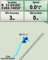
| Thu 21 Mar 2019 in 52,4: 52.6416366, 4.7405830 geohashing.info google osm bing/os kml crox |
Location
A park in Alkmaar, North Holland province, Netherlands.
Participants
Expedition
Today's hash was located in a park in the old city of Alkmaar. This park was less than 500 metres from the train station, so I decided to travel there by train after work. I first took the Amsterdam Metro to Sloterdijk train station, then got on the Intercity service to Alkmaar. All of this took about 45 minutes. Once in Alkmaar I walked to the park, which was quite a nice place, but completely deserted on a grey weekday evening around dinner time. The hash was right next to a kind of teepee-like structure made from branches. I took a few pictures and then went back to the train station. The ride back home took about an hour and a half, mainly because there are not many fast trains in this semi-rural part of the country.
Photos

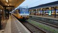
Arriving at Sloterdijk station.
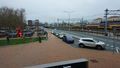
Arriving at Alkmaar.
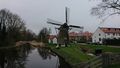
A very typical Dutch scene with a windmill draining a polder.
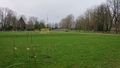
The park, with a football pitch, a small amphitheatre and much more. The hash is behind all this.
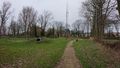
The far end of the park, with wooden contraptions for climbing on and what looks like a hobbit house right in front.
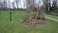
The tent-like structure with the hash in front.
Reached it!
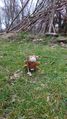
Lloyd celebrating.
Another view of the park, with spring flowers.
The first of three trains to get me back home.


Achievements
FelixTheCat (talk) earned the Public transport geohash achievement
|