Difference between revisions of "2019-03-23 42 -120"
imported>Michael5000 (Created page with "{{subst:Expedition |lat = 42 |lon = -120 |date = 2019-03-23 }}") |
m (per Renaming Proposal) |
||
| (9 intermediate revisions by 2 users not shown) | |||
| Line 1: | Line 1: | ||
| − | + | [[Image:{{{image|2019-03-23 42 -120 view 2.jpg}}}|thumb|left]] | |
| − | |||
| − | |||
| − | |||
| − | |||
| − | |||
| − | |||
| − | |||
{{meetup graticule | {{meetup graticule | ||
| lat=42 | | lat=42 | ||
| Line 19: | Line 12: | ||
== Location == | == Location == | ||
| − | + | ||
| + | In a snow-covered turnoff off of Highway 140. | ||
== Participants == | == Participants == | ||
| − | |||
| − | |||
| − | + | * [[User:Michael5000|Michael5000]] | |
| − | |||
== Expedition == | == Expedition == | ||
| − | |||
| − | + | So, continuing from [[2019-03-23 43 -120]], I drove south on US 385, only the second time I've traveled that road. It periodically rained and then snowed, so I wasn't able to focus on the scenery, but the scenery and the drive were both pretty dramatic. The weather had stabilized when I got to the intersection with US 140, which climbs rapidly up into snowy ridges but was cleared and easy to drive on. The hashpoint is on a gravel turnoff if you look on Google Maps, but as I found it it was a big field of perfect white snow. I've never lived anyplace that it snows much, so I've only waded out into a snow field a few times in my life. It was fun! | |
| − | + | ||
| + | Then I got back in the car and headed down the hill to the town of Lakeview, namesake of the graticule that I had just geohashed -- the first person ever to do such a thing! I was not met with a parade, but they sold me some food and gasoline. I started the long drive back to Prineville, using the very pretty Paisley highway this time; the rain and snow was very heavy at first but I soon got west of the weather and before sundown even saw a hint of blue sky. | ||
== Photos == | == Photos == | ||
| − | |||
| − | |||
| − | |||
<gallery perrow="5"> | <gallery perrow="5"> | ||
| + | File:2019-03-23 42 -120 turnout.jpg|The hashpoint is usually a turnoff from Highway 140, but there was no turning off today. | ||
| + | File:2019-03-23 42 -120 car.jpg| So, I just parked at the side of the road. There wasn't any traffic. | ||
| + | File:2019-03-23 42 -120 me 2.jpg|I trudged out to the hashpoint. | ||
| + | File:2019-03-23 42 -120 deep.jpg|...through snow up to my knees! | ||
| + | File:2019-03-23 42 -120 view 2.jpg|It was very pretty. | ||
</gallery> | </gallery> | ||
| Line 45: | Line 38: | ||
<!-- Add any achievement ribbons you earned below, or remove this section --> | <!-- Add any achievement ribbons you earned below, or remove this section --> | ||
| − | + | [[Category:Expeditions]] | |
| − | + | [[Category:Expeditions with photos]] | |
| − | [[Category: | + | [[Category:Coordinates reached]] |
| + | |||
| − | |||
| − | + | {{Multihash2 | count = 2 | date = 2019-03-23 | name = Michael5000}} | |
| − | |||
| − | |||
| − | |||
| − | |||
| − | + | {{Graticule unlocked | |
| − | + | | latitude = 42 | |
| − | -- | + | | longitude = -120 |
| − | + | | date = 2019-03-23 | |
| − | + | | name = [[User:Michael5000|Michael5000]] | |
| − | [[ | + | | image = 2019-03-23 42 -120 me 2.jpg |
| − | -- | + | }} |
| − | |||
| − | |||
| − | |||
| − | |||
| − | |||
| − | |||
| − | |||
| − | |||
| − | |||
| − | |||
| − | |||
| − | |||
| − | |||
| − | + | {{Minesweeper geohash | |
| − | [[ | + | | graticule = [[La Pine, Oregon]] |
| − | + | | ranknumber = 7 | |
| − | + | | n = true | |
| − | [[ | + | | ne = true |
| + | | e = true | ||
| + | | nw = true | ||
| + | | sw = true | ||
| + | | s = true | ||
| + | | se = true | ||
| + | | name = [[User:Michael5000|Michael5000]] | ||
| + | }} | ||
| − | + | {{Minesweeper geohash | |
| + | | graticule = [[Hampton, Oregon]] | ||
| + | | ranknumber = 5 | ||
| + | | nw = true | ||
| + | | n = true | ||
| + | | w = true | ||
| + | | sw = true | ||
| + | | s = true | ||
| + | | name = [[User:Michael5000|Michael5000]] | ||
| + | }} | ||
| + | {{location|US|OR|LK}} | ||
Latest revision as of 04:51, 20 March 2024

| Sat 23 Mar 2019 in 42,-120: 42.2213311, -120.1555120 geohashing.info google osm bing/os kml crox |
Location
In a snow-covered turnoff off of Highway 140.
Participants
Expedition
So, continuing from 2019-03-23 43 -120, I drove south on US 385, only the second time I've traveled that road. It periodically rained and then snowed, so I wasn't able to focus on the scenery, but the scenery and the drive were both pretty dramatic. The weather had stabilized when I got to the intersection with US 140, which climbs rapidly up into snowy ridges but was cleared and easy to drive on. The hashpoint is on a gravel turnoff if you look on Google Maps, but as I found it it was a big field of perfect white snow. I've never lived anyplace that it snows much, so I've only waded out into a snow field a few times in my life. It was fun!
Then I got back in the car and headed down the hill to the town of Lakeview, namesake of the graticule that I had just geohashed -- the first person ever to do such a thing! I was not met with a parade, but they sold me some food and gasoline. I started the long drive back to Prineville, using the very pretty Paisley highway this time; the rain and snow was very heavy at first but I soon got west of the weather and before sundown even saw a hint of blue sky.
Photos
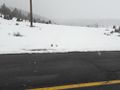
The hashpoint is usually a turnoff from Highway 140, but there was no turning off today.
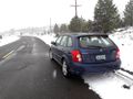
So, I just parked at the side of the road. There wasn't any traffic.

I trudged out to the hashpoint.

...through snow up to my knees!
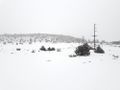
It was very pretty.


Achievements
Michael5000 earned the Multihash Achievement
|
Michael5000 earned the Graticule Unlocked Achievement
|
Michael5000 achieved level 7 of the Minesweeper Geohash achievement
|
Michael5000 achieved level 5 of the Minesweeper Geohash achievement
|