Difference between revisions of "2019-03-24 44 -123"
imported>Michael5000 (Created page with "{{subst:Expedition |lat = 44 |lon = -123 |date = 2019-03-24 }}") |
imported>FippeBot m (Location) |
||
| (4 intermediate revisions by one other user not shown) | |||
| Line 1: | Line 1: | ||
| − | |||
| − | [[Image:{{{image| | + | [[Image:{{{image|2019-03-24 44 -123 Tree.jpg}}}|thumb|left]] |
| − | |||
| − | |||
| − | |||
| − | |||
{{meetup graticule | {{meetup graticule | ||
| lat=44 | | lat=44 | ||
| Line 19: | Line 14: | ||
== Location == | == Location == | ||
| − | + | ||
| + | On a residential lot on Orchard Heights Road in West Salem. | ||
== Participants == | == Participants == | ||
| − | |||
| − | |||
| − | + | * [[User:Michael5000|Michael5000]] | |
| − | |||
== Expedition == | == Expedition == | ||
| − | |||
| − | + | I drove home from [[2019-03-23 43 -120]] and [[2019-03-23 42 -120]] via Redmond, where I went for a run in their smashing Dry Canyon Park, and then over the Cascades on Oregon Highway 20, and ended up in the West Salem neighborhood for the second time in eight days. | |
| − | + | ||
| + | Last Saturday is the first time I remember ever passing through West Salem, on my way from Corvallis to the [[2019-03-16 45 -122]] Expedition. Since then, oddly, Mrs.5000 had a successful expedition there ([[2019-03-20 44 -123]]) on Wednesday. In short, West Salem is really a red-hot hub of the international geohashing scene, or at least that's what it feels like at our house. | ||
| + | |||
| + | Anyway, I parked at the local branch of a well-known coffeeshop chain, and spent a while there writing up and posting the previous three expeditions. That being done, I took my coffee and my GPS unit on a little quarter-mile walk up the hill to find the hashpoint. It was a lovely spring evening, and a great way to wrap up the road trip. | ||
== Photos == | == Photos == | ||
| − | + | ||
| − | |||
| − | |||
<gallery perrow="5"> | <gallery perrow="5"> | ||
| + | File:2019-03-24 44 -123 Tree.jpg|The hashpoint tree. | ||
| + | File:2019-03-24 44 -123 me.jpg|Jubilant at another successful expedition. | ||
| + | File:2019-03-24 44 -123 View.jpg|You could see the state capital building over across the river, with the shiny statue on top. | ||
</gallery> | </gallery> | ||
== Achievements == | == Achievements == | ||
{{#vardefine:ribbonwidth|800px}} | {{#vardefine:ribbonwidth|800px}} | ||
| − | |||
| − | |||
| − | |||
| − | |||
| − | |||
| − | |||
| − | |||
| − | |||
| − | |||
| − | |||
| − | |||
| − | |||
| − | |||
| − | |||
| − | |||
[[Category:Expeditions]] | [[Category:Expeditions]] | ||
| − | |||
[[Category:Expeditions with photos]] | [[Category:Expeditions with photos]] | ||
| − | |||
| − | |||
| − | |||
| − | |||
| − | |||
| − | |||
| − | |||
[[Category:Coordinates reached]] | [[Category:Coordinates reached]] | ||
| − | + | {{location|US|OR|PO}} | |
| − | |||
| − | |||
| − | |||
| − | |||
| − | |||
| − | |||
| − | |||
| − | |||
| − | |||
| − | |||
| − | |||
| − | |||
| − | |||
| − | |||
| − | |||
| − | |||
| − | |||
Latest revision as of 03:36, 7 August 2019

| Sun 24 Mar 2019 in 44,-123: 44.9538065, -123.0546367 geohashing.info google osm bing/os kml crox |
Location
On a residential lot on Orchard Heights Road in West Salem.
Participants
Expedition
I drove home from 2019-03-23 43 -120 and 2019-03-23 42 -120 via Redmond, where I went for a run in their smashing Dry Canyon Park, and then over the Cascades on Oregon Highway 20, and ended up in the West Salem neighborhood for the second time in eight days.
Last Saturday is the first time I remember ever passing through West Salem, on my way from Corvallis to the 2019-03-16 45 -122 Expedition. Since then, oddly, Mrs.5000 had a successful expedition there (2019-03-20 44 -123) on Wednesday. In short, West Salem is really a red-hot hub of the international geohashing scene, or at least that's what it feels like at our house.
Anyway, I parked at the local branch of a well-known coffeeshop chain, and spent a while there writing up and posting the previous three expeditions. That being done, I took my coffee and my GPS unit on a little quarter-mile walk up the hill to find the hashpoint. It was a lovely spring evening, and a great way to wrap up the road trip.
Photos
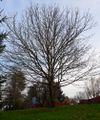
The hashpoint tree.
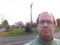
Jubilant at another successful expedition.
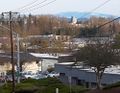
You could see the state capital building over across the river, with the shiny statue on top.

