Difference between revisions of "2019-03-27 51 11"
imported>GeorgDerReisende (new report) |
imported>GeorgDerReisende (expedition report for Artern) |
||
| Line 1: | Line 1: | ||
| + | [[Image:{{{image|2019-03-27 51 11 GeorgDerReisende 0001.jpg}}}|thumb|left]] | ||
| − | |||
| − | |||
| − | |||
| − | |||
| − | |||
| − | |||
| − | |||
| − | |||
| − | |||
{{meetup graticule | {{meetup graticule | ||
| lat=51 | | lat=51 | ||
| Line 19: | Line 11: | ||
== Location == | == Location == | ||
| − | + | ||
| + | The hash lay in the Unstrutstraße in Artern. | ||
== Participants == | == Participants == | ||
| − | + | ||
| − | + | [[User:GeorgDerReisende|GeorgDerReisende]] | |
== Plans == | == Plans == | ||
| − | + | ||
| + | Traveling to Artern by public transport and walking around. | ||
== Expedition == | == Expedition == | ||
| − | |||
| − | + | I left home at 10:30 and arrived at Artern at 13:50. Then I made a walk around Artern. Then I walked to the hash. What looked like a fence with a gate was in nature a ditch with a bridge. Without the Garmin I only knew that the hash was in three quarters of the north side of the street and about three quarters to the left of the gate/bridge. And I stood there. But I noticed that I don't know the directions without the Garmin. | |
| − | |||
== Photos == | == Photos == | ||
| − | + | ||
| − | |||
| − | |||
<gallery perrow="5"> | <gallery perrow="5"> | ||
| + | 2019-03-27 51 11 GeorgDerReisende 2096.jpg | arrived | ||
| + | 2019-03-27 51 11 GeorgDerReisende 2384.jpg | Unstrutstraße | ||
| + | 2019-03-27 51 11 GeorgDerReisende 2388.jpg | the trees on the western side of the field for navigation | ||
| + | 2019-03-27 51 11 GeorgDerReisende 2390.jpg | the hash in this line | ||
| + | 2019-03-27 51 11 GeorgDerReisende 2391.jpg | a bridge across the ditch to the field | ||
| + | 2019-03-27 51 11 GeorgDerReisende 2392.jpg | looking to the field | ||
| + | 2019-03-27 51 11 GeorgDerReisende 2393.jpg | but where is the north? | ||
| + | 2019-03-27 51 11 GeorgDerReisende 2394.jpg | looking to the north | ||
| + | 2019-03-27 51 11 GeorgDerReisende 2395.jpg | looking to the north | ||
| + | 2019-03-27 51 11 GeorgDerReisende 2396.jpg | looking to the north | ||
| + | 2019-03-27 51 11 GeorgDerReisende 2397.jpg | the geohasher | ||
</gallery> | </gallery> | ||
| − | + | [[Category:Expeditions]] | |
| − | |||
| − | |||
| − | + | [[Category:Expeditions with photos]] | |
| − | |||
| − | [[Category: | ||
| − | + | [[Category:Expedition without GPS]] | |
| − | + | {{location|DE|TH|KYF}} | |
| − | |||
| − | |||
| − | |||
| − | |||
| − | |||
| − | |||
| − | |||
| − | |||
| − | |||
| − | |||
| − | |||
| − | |||
| − | |||
| − | |||
| − | |||
| − | |||
[[Category:Coordinates reached]] | [[Category:Coordinates reached]] | ||
| − | |||
| − | |||
| − | |||
| − | |||
| − | |||
| − | |||
| − | |||
| − | |||
| − | |||
| − | |||
| − | |||
| − | |||
| − | |||
| − | |||
| − | |||
| − | |||
| − | |||
| − | |||
Latest revision as of 09:13, 28 March 2019

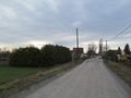
| Wed 27 Mar 2019 in 51,11: 51.3586954, 11.2933624 geohashing.info google osm bing/os kml crox |
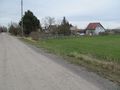
Location
The hash lay in the Unstrutstraße in Artern.
Participants
Plans
Traveling to Artern by public transport and walking around.
Expedition
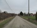
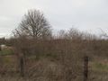
I left home at 10:30 and arrived at Artern at 13:50. Then I made a walk around Artern. Then I walked to the hash. What looked like a fence with a gate was in nature a ditch with a bridge. Without the Garmin I only knew that the hash was in three quarters of the north side of the street and about three quarters to the left of the gate/bridge. And I stood there. But I noticed that I don't know the directions without the Garmin.
Photos
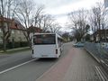
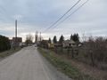
arrived
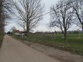
Unstrutstraße
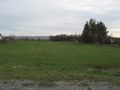
the trees on the western side of the field for navigation
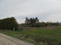
the hash in this line
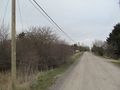
a bridge across the ditch to the field
looking to the field
but where is the north?
looking to the north
looking to the north
looking to the north
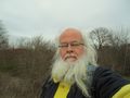
the geohasher


