Difference between revisions of "2019-04-14 51 -2"
imported>Saxbophone |
imported>Fippe (coordinates reached) |
||
| (4 intermediate revisions by 2 users not shown) | |||
| Line 20: | Line 20: | ||
== Location == | == Location == | ||
<!-- where you've surveyed the hash to be --> | <!-- where you've surveyed the hash to be --> | ||
| − | Today I ([[User:NathanielBryceson]]) went on my first ever Geohashing expedition, went with his 4x great grandson, [[User:Saxbophone]]. | + | Today I ([[User:NathanielBryceson|NathanielBryceson]]) went on my first ever Geohashing expedition, went with his 4x great grandson, [[User:Saxbophone|Saxbophone]]. |
It was in the [[Bristol, United Kingdom]] graticule. | It was in the [[Bristol, United Kingdom]] graticule. | ||
| Line 26: | Line 26: | ||
<!-- who attended: If you link to your wiki user name in this section, your expedition will be picked up by the various statistics generated for geohashing. You may use three tildes ~ as a shortcut to automatically insert the user signature of the account you are editing with. | <!-- who attended: If you link to your wiki user name in this section, your expedition will be picked up by the various statistics generated for geohashing. You may use three tildes ~ as a shortcut to automatically insert the user signature of the account you are editing with. | ||
--> | --> | ||
| − | * [[User:NathanielBryceson]] | + | * [[User:NathanielBryceson|NathanielBryceson]] |
| − | * [[User:Saxbophone]] | + | * [[User:Saxbophone|Saxbophone]] |
== Plans == | == Plans == | ||
| Line 50: | Line 50: | ||
== Tracklog == | == Tracklog == | ||
<!-- if your GPS device keeps a log, you may post a link here --> | <!-- if your GPS device keeps a log, you may post a link here --> | ||
| − | This will kindly be provided by [[User:Saxbophone]] who had an interesting device called a GPS receiver with him: | + | This will kindly be provided by [[User:Saxbophone|Saxbophone]] who had an interesting device called a GPS receiver with him: |
Such modern fangled technology these days. | Such modern fangled technology these days. | ||
| Line 65: | Line 65: | ||
<!-- Add any achievement ribbons you earned below, or remove this section --> | <!-- Add any achievement ribbons you earned below, or remove this section --> | ||
| − | |||
| − | |||
| − | |||
| − | |||
| − | |||
| − | |||
| − | |||
| − | |||
| − | |||
| − | |||
| − | |||
| − | |||
| − | |||
| − | |||
[[Category:Expeditions]] | [[Category:Expeditions]] | ||
| − | |||
[[Category:Expeditions with photos]] | [[Category:Expeditions with photos]] | ||
| − | + | {{location|GB|ENG|GLS}} | |
| − | |||
| − | |||
| − | {{location}} | ||
| − | |||
| − | |||
| − | |||
[[Category:Coordinates reached]] | [[Category:Coordinates reached]] | ||
| − | |||
| − | |||
| − | |||
| − | |||
| − | |||
| − | |||
| − | |||
| − | |||
| − | |||
| − | |||
| − | |||
| − | |||
| − | |||
| − | |||
| − | |||
| − | |||
| − | |||
| − | |||
Latest revision as of 12:01, 27 July 2019
| Sun 14 Apr 2019 in 51,-2: 51.6625758, -2.1490940 geohashing.info google osm bing/os kml crox |
Location
Today I (NathanielBryceson) went on my first ever Geohashing expedition, went with his 4x great grandson, Saxbophone. It was in the Bristol, United Kingdom graticule.
Participants
Plans
We went a day early to check out the location and whether it was accessible. But we recorded it anyway.
Expedition
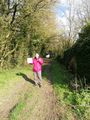
We realised the location was in the middle of a field! We wondered if we could access via a nearby Blacksmiths business but it was closed. We then discovered a foot path ran behind the field. It was a glorious walk to the field. We passed horses, sheep and forest. We discovered the pathway passed into the field and we were able to get quite close. A deer leaped out from near the location: what a lovely site. We then took a lovely walk back to the car. We drove to a spot of interest nearby: the source of the River Avon. What a wonderful introduction to the world of Geohashing. It was well worth the time travel from the 1840s.
Tracklog
This will kindly be provided by Saxbophone who had an interesting device called a GPS receiver with him: Such modern fangled technology these days.
Photos
My First Geohash
