Difference between revisions of "2019-04-15 51 8"
imported>GeorgDerReisende (new report) |
imported>GeorgDerReisende (expedition report for Gütersloh) |
||
| Line 1: | Line 1: | ||
| − | + | [[Image:{{{image|2019-04-15 51 8 GeorgDerReisende 0001.jpg}}}|thumb|left]] | |
| − | |||
| − | |||
| − | [[Image:{{{image| | ||
| − | |||
| − | |||
| − | |||
| − | |||
| − | |||
| − | |||
{{meetup graticule | {{meetup graticule | ||
| lat=51 | | lat=51 | ||
| Line 19: | Line 10: | ||
== Location == | == Location == | ||
| − | + | ||
| + | The hash lay under a tree in Gütersloh-Pavenstädt. | ||
== Participants == | == Participants == | ||
| − | + | ||
| − | + | [[User:GeorgDerReisende|GeorgDerReisende]] | |
== Plans == | == Plans == | ||
| − | + | ||
| + | ??? | ||
== Expedition == | == Expedition == | ||
| − | |||
| − | + | I left home at 7 o'clock and by two trams, three trains and a bus I arrived at the county council of Gütersloh. From there I walked to the hash. Because I don't have a GPS at the moment I could only guess, where the hash was and because the areal view showed it north of the tree, I say that I have reached it within five meters. There was a deep ditch at the side of the tree, where I could not walk in. | |
| − | |||
== Photos == | == Photos == | ||
| − | |||
| − | |||
| − | |||
<gallery perrow="5"> | <gallery perrow="5"> | ||
| + | 2019-04-15 51 8 GeorgDerReisende 4768.jpg | arrived at the county council | ||
| + | 2019-04-15 51 8 GeorgDerReisende 4803.jpg | first view to tree | ||
| + | 2019-04-15 51 8 GeorgDerReisende 4816.jpg | second view to tree | ||
| + | 2019-04-15 51 8 GeorgDerReisende 4817.jpg | there is a ditch with nettles | ||
| + | 2019-04-15 51 8 GeorgDerReisende 4818.jpg | third view to the tree | ||
| + | 2019-04-15 51 8 GeorgDerReisende 4819.jpg | I am standing here, but where is the north? | ||
| + | 2019-04-15 51 8 GeorgDerReisende 4820.jpg | looking to the ditch | ||
| + | 2019-04-15 51 8 GeorgDerReisende 4821.jpg | looking somewhere north | ||
| + | 2019-04-15 51 8 GeorgDerReisende 4822.jpg | looking somewhere east | ||
| + | 2019-04-15 51 8 GeorgDerReisende 4823.jpg | looking somewhere south | ||
| + | 2019-04-15 51 8 GeorgDerReisende 4824.jpg | looking somewhere west | ||
| + | 2019-04-15 51 8 GeorgDerReisende 4825.jpg | the geohasher | ||
</gallery> | </gallery> | ||
| − | + | [[Category:Expeditions]] | |
| − | |||
| − | |||
| − | + | [[Category:Expeditions with photos]] | |
| − | |||
| − | [[Category: | ||
| − | + | [[Category:Expedition without GPS]] | |
| − | + | {{location|DE|NW|GT}} | |
| − | |||
| − | |||
| − | |||
| − | |||
| − | |||
| − | |||
| − | |||
| − | |||
| − | |||
| − | |||
| − | |||
| − | |||
| − | |||
| − | |||
| − | |||
| − | |||
[[Category:Coordinates reached]] | [[Category:Coordinates reached]] | ||
| − | |||
| − | |||
| − | |||
| − | |||
| − | |||
| − | |||
| − | |||
| − | |||
| − | |||
| − | |||
| − | |||
| − | |||
| − | |||
| − | |||
| − | |||
| − | |||
| − | |||
| − | |||
Latest revision as of 10:08, 17 April 2019

| Mon 15 Apr 2019 in 51,8: 51.9081635, 8.3363404 geohashing.info google osm bing/os kml crox |
Location
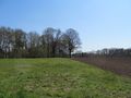
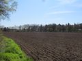
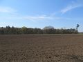
The hash lay under a tree in Gütersloh-Pavenstädt.
Participants
Plans
???
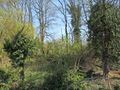
Expedition
I left home at 7 o'clock and by two trams, three trains and a bus I arrived at the county council of Gütersloh. From there I walked to the hash. Because I don't have a GPS at the moment I could only guess, where the hash was and because the areal view showed it north of the tree, I say that I have reached it within five meters. There was a deep ditch at the side of the tree, where I could not walk in.
Photos
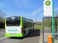
arrived at the county council
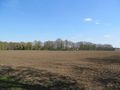
first view to tree
second view to tree
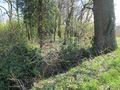
there is a ditch with nettles
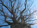
third view to the tree
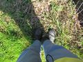
I am standing here, but where is the north?
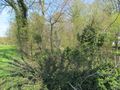
looking to the ditch
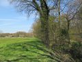
looking somewhere north
looking somewhere east
looking somewhere south
looking somewhere west
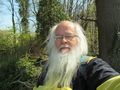
the geohasher


