Difference between revisions of "2019-04-27 62 29"
imported>Kripakko |
imported>Fippe (Coordinates reached, so I removed category:expedition planning.) |
||
| (4 intermediate revisions by 2 users not shown) | |||
| Line 1: | Line 1: | ||
| − | |||
| − | |||
| − | |||
| − | |||
| − | |||
| − | |||
| − | |||
| − | |||
| − | |||
| − | |||
{{meetup graticule | {{meetup graticule | ||
| lat=62 | | lat=62 | ||
| Line 19: | Line 9: | ||
== Location == | == Location == | ||
| − | + | On the yard of Lehmo school in Kontiolahti. | |
| − | |||
| − | On the | ||
== Participants == | == Participants == | ||
| − | |||
| − | |||
| − | |||
*[[User:Kripakko|Kripakko]] | *[[User:Kripakko|Kripakko]] | ||
== Plans == | == Plans == | ||
| − | |||
I have already planned to cycle to Koli in the morning, and this hashpoint is only 90 metres away from my planned route. I will definitely make the detour to visit this if entering the yard is not forbidden. | I have already planned to cycle to Koli in the morning, and this hashpoint is only 90 metres away from my planned route. I will definitely make the detour to visit this if entering the yard is not forbidden. | ||
== Expedition == | == Expedition == | ||
| − | + | As I had anticipated, this hashpoint was very easy to reach, and since it was Saturday morning, there were no other people in the school area. I could cycle right to the hashpoint and take some pictures. After about ten minutes, I continued my cycling trip. I returned to home by car however, so I cannot claim the whole cycled distance, only the first 4.4 km from my home to the hashpoint. | |
| − | |||
| − | |||
| − | |||
| − | == Photos == | + | == Photos == |
| − | |||
| − | |||
| − | |||
<gallery perrow="5"> | <gallery perrow="5"> | ||
| + | Image:2019-04-27_62_29_01-entrance.jpg|Entrance to the school yard. | ||
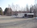
| + | Image:2019-04-27_62_29_02-building.jpg|An old school building. | ||
| + | Image:2019-04-27_62_29_03-bicycle1.jpg|Bicycle at the hashpoint. | ||
| + | Image:2019-04-27_62_29_04-bicycle2.jpg|Bicycle at the hashpoint, wider shot. | ||
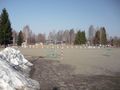
| + | Image:2019-04-27_62_29_05-railway.jpg|School yard equipment and the railway. | ||
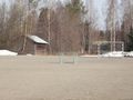
| + | Image:2019-04-27_62_29_06-rink.jpg|A rink on the yard. | ||
| + | Image:2019-04-27_62_29_07-barn.jpg|An old barn in the forest. | ||
| + | Image:2019-04-27_62_29_08-gpsr.jpg|GPS proof: hashpoint reached. | ||
| + | Image:2019-04-27_62_29_09-selfie.jpg|Me at the hashpoint. | ||
| + | Image:2019-04-27_62_29_10-hare.jpg|Spot a hare in the picture. | ||
</gallery> | </gallery> | ||
== Achievements == | == Achievements == | ||
{{#vardefine:ribbonwidth|800px}} | {{#vardefine:ribbonwidth|800px}} | ||
| − | + | {{land geohash | latitude = 62 | longitude = 29 | date = 2019-04-27 | name = Kripakko}} | |
| − | + | {{bicycle geohash | latitude = 62 | longitude = 29 | date = 2019-04-27 | name = Kripakko | distance = 4.4 km }} | |
| − | |||
| − | |||
| − | |||
| − | |||
| − | |||
| − | |||
| − | |||
| − | |||
| − | |||
| − | |||
| − | |||
| − | |||
| − | |||
| − | |||
[[Category:Expeditions]] | [[Category:Expeditions]] | ||
| − | + | [[Category:Coordinates reached]] | |
[[Category:Expeditions with photos]] | [[Category:Expeditions with photos]] | ||
| − | + | {{location|FI|13}} | |
| − | |||
| − | |||
| − | {{location}} | ||
| − | |||
| − | |||
| − | |||
| − | |||
| − | |||
| − | |||
| − | |||
| − | |||
| − | |||
| − | |||
| − | |||
| − | |||
| − | |||
| − | |||
| − | |||
| − | |||
| − | |||
| − | |||
| − | |||
| − | |||
| − | |||
| − | |||
Latest revision as of 11:26, 25 July 2019
| Sat 27 Apr 2019 in 62,29: 62.6495409, 29.8125533 geohashing.info google osm bing/os kml crox |
Location
On the yard of Lehmo school in Kontiolahti.
Participants
Plans
I have already planned to cycle to Koli in the morning, and this hashpoint is only 90 metres away from my planned route. I will definitely make the detour to visit this if entering the yard is not forbidden.
Expedition
As I had anticipated, this hashpoint was very easy to reach, and since it was Saturday morning, there were no other people in the school area. I could cycle right to the hashpoint and take some pictures. After about ten minutes, I continued my cycling trip. I returned to home by car however, so I cannot claim the whole cycled distance, only the first 4.4 km from my home to the hashpoint.
Photos
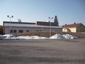
Entrance to the school yard.
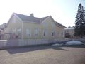
An old school building.
Bicycle at the hashpoint.
Bicycle at the hashpoint, wider shot.
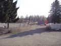
School yard equipment and the railway.
A rink on the yard.
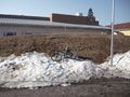
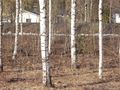
An old barn in the forest.
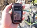
GPS proof: hashpoint reached.
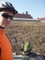
Me at the hashpoint.
Spot a hare in the picture.


Achievements
Kripakko earned the Land geohash achievement
|
Kripakko earned the Bicycle geohash achievement
|