Difference between revisions of "2019-04-30 51 9"
From Geohashing
imported>GeorgDerReisende (new report) |
imported>GeorgDerReisende (expedition report for Einbeck) |
||
| Line 1: | Line 1: | ||
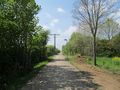
| + | [[Image:{{{image|2019-04-30 51 9 GeorgDerReisende 0001.jpg}}}|thumb|left]] | ||
| − | |||
| − | |||
| − | |||
| − | |||
| − | |||
| − | |||
| − | |||
| − | |||
| − | |||
{{meetup graticule | {{meetup graticule | ||
| lat=51 | | lat=51 | ||
| Line 19: | Line 11: | ||
== Location == | == Location == | ||
| − | + | ||
| + | The hash lay on the edge of a field at the Königsberger Straße in Einbeck. | ||
== Participants == | == Participants == | ||
| − | + | ||
| − | + | [[User:GeorgDerReisende|GeorgDerReisende]] | |
== Plans == | == Plans == | ||
| − | + | ||
| + | Traveling by public transport and a walk. | ||
== Expedition == | == Expedition == | ||
| − | |||
| − | + | With a bus and three trains I arrived at Einbeck. I walked around the city and to the hash. I waited for an empty field but I found a new building on it. But the building didn't use the whole field, and I could easyly reach the hash. | |
| − | |||
== Photos == | == Photos == | ||
| − | |||
| − | |||
| − | |||
<gallery perrow="5"> | <gallery perrow="5"> | ||
| + | 2019-04-30 51 9 GeorgDerReisende 6400.jpg | intead of a free field I found a new building | ||
| + | 2019-04-30 51 9 GeorgDerReisende 6404.jpg | but the path around the field remained | ||
| + | 2019-04-30 51 9 GeorgDerReisende 6407.jpg | looking to the hash | ||
| + | 2019-04-30 51 9 GeorgDerReisende 6408.jpg | nearest view | ||
| + | 2019-04-30 51 9 GeorgDerReisende 6409.jpg | with a GPS I would try to get nearer, now I can only use my finger | ||
| + | 2019-04-30 51 9 GeorgDerReisende 6410.jpg | looking north | ||
| + | 2019-04-30 51 9 GeorgDerReisende 6411.jpg | looking south | ||
| + | 2019-04-30 51 9 GeorgDerReisende 6412.jpg | the geohasher at the hash | ||
| + | 2019-04-30 51 9 GeorgDerReisende 6415.jpg | the Königsberger Straße to the west | ||
| + | 2019-04-30 51 9 GeorgDerReisende 6416.jpg | the Königsberger Straße to the east | ||
| + | 2019-04-30 51 9 GeorgDerReisende 6419.jpg | the landscape behind the bush | ||
</gallery> | </gallery> | ||
| − | + | [[Category:Expeditions]] | |
| − | |||
| − | |||
| − | + | [[Category:Expeditions with photos]] | |
| − | |||
| − | [[Category: | ||
| − | + | [[Category:Expedition without GPS]] | |
| − | + | {{location|DE|NI|NOM}} | |
| − | |||
| − | |||
| − | |||
| − | |||
| − | |||
| − | |||
| − | |||
| − | |||
| − | |||
| − | |||
| − | |||
| − | |||
| − | |||
| − | |||
| − | |||
| − | |||
[[Category:Coordinates reached]] | [[Category:Coordinates reached]] | ||
| − | |||
| − | |||
| − | |||
| − | |||
| − | |||
| − | |||
| − | |||
| − | |||
| − | |||
| − | |||
| − | |||
| − | |||
| − | |||
| − | |||
| − | |||
| − | |||
| − | |||
| − | |||
Latest revision as of 06:59, 4 May 2019

| Tue 30 Apr 2019 in 51,9: 51.8123379, 9.8494499 geohashing.info google osm bing/os kml crox |
Location
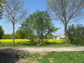
The hash lay on the edge of a field at the Königsberger Straße in Einbeck.
Participants
Plans
Traveling by public transport and a walk.
Expedition
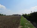
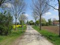
With a bus and three trains I arrived at Einbeck. I walked around the city and to the hash. I waited for an empty field but I found a new building on it. But the building didn't use the whole field, and I could easyly reach the hash.
Photos
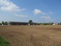
intead of a free field I found a new building
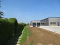
but the path around the field remained
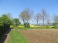
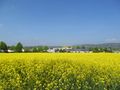
looking to the hash
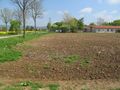
nearest view
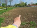
with a GPS I would try to get nearer, now I can only use my finger
looking north
looking south
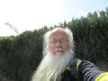
the geohasher at the hash
the Königsberger Straße to the west
the Königsberger Straße to the east
the landscape behind the bush


