Difference between revisions of "2019-05-18 51 5"
imported>FelixTheCat (Created page with "{{subst:Expedition |lat = 51 |lon = 5 |date = 2019-05-18 }}") |
imported>FippeBot m (Location) |
||
| (2 intermediate revisions by one other user not shown) | |||
| Line 1: | Line 1: | ||
| − | |||
| − | |||
| − | |||
| − | |||
| − | |||
| − | |||
| − | |||
| − | |||
| − | |||
| − | |||
{{meetup graticule | {{meetup graticule | ||
| lat=51 | | lat=51 | ||
| Line 14: | Line 4: | ||
| date=2019-05-18 | | date=2019-05-18 | ||
}} | }} | ||
| − | |||
| − | |||
__NOTOC__ | __NOTOC__ | ||
== Location == | == Location == | ||
| − | + | A field just to the north of Tiel, Gelderland province. | |
== Participants == | == Participants == | ||
| − | + | [[User:FelixTheCat|FelixTheCat]] ([[User talk:FelixTheCat|talk]]) | |
| − | |||
| − | |||
| − | |||
| − | |||
== Expedition == | == Expedition == | ||
| − | + | Today's hash was on the edge of a field to the north of the city of Tiel. I went there by train, changing at Dordrecht and Geldermalsen. The train journey took a little under two hours and took me through beautiful green landscapes. At Tiel station I rented a bike and rode north to reach the hash field. The field didn't look like it was being used and was overgrown with long grass and weeds. Still, there was a red/white ribbon at the entrance, clearly showing that it belonged to someone and that person didn't want people to enter it at random. The hash was right at the edge of the field, so I had reckoned I would be able to reach it without trespassing, but as it turned out there was a drainage ditch. Worried that this would become yet another My Kingdom For A Boat I walked closer to the edge, and with a bit of dancing and stretching out as far as I dared, I managed to reach the point and even score zero distance! I took some pictures and then rode back to Tiel, where I visited the museum of local history which had a very interesting exhibit on the history of jam and juice, Tiel being the centre of the Dutch fruit industry. | |
| − | |||
| − | |||
| − | |||
== Photos == | == Photos == | ||
| − | |||
| − | |||
| − | |||
<gallery perrow="5"> | <gallery perrow="5"> | ||
| + | Image:2019-05-18 52 5 FelixTheCat 1.JPG | The first train, a VIRM towards Dordrecht. | ||
| + | Image:2019-05-18 52 5 FelixTheCat 2.JPG | At Dordrecht, changed onto this Spurt train towards Geldermalsen, operated by Qbuzz (who apparently also run trainzz) | ||
| + | Image:2019-05-18 52 5 FelixTheCat 3.JPG | A beautiful day in Holland's green and pleasant land. | ||
| + | Image:2019-05-18 52 5 FelixTheCat 4.JPG | At Geldermalsen I changed onto this SLT towards Tiel. | ||
| + | Image:2019-05-18 52 5 FelixTheCat 5.JPG | At Tiel station. | ||
| + | Image:2019-05-18 52 5 FelixTheCat 6.JPG | My hash bike for today. | ||
| + | Image:2019-05-18 52 5 FelixTheCat 7.JPG | Crossing the Amsterdam-Rhine Canal (which, you guessed it, connects Amsterdam to the Rhine). Apparently it's one of the busiest shipping canals in the world, but today it was deserted. | ||
| + | Image:2019-05-18 52 5 FelixTheCat 8.JPG | The hash road, the rather oddly named Rechtopweg ("upright road"). | ||
| + | Image:2019-05-18 52 5 FelixTheCat 9.JPG | The hash field, with the blocked entrance and the drainage ditch. | ||
| + | Image:2019-05-18 52 5 FelixTheCat 10.JPG | The hash is right about here. | ||
| + | Image:2019-05-18 52 5 FelixTheCat 11.png | Precariously balancing myself on the edge I managed to reach it! | ||
| + | Image:2019-05-18 52 5 FelixTheCat 12.JPG | Lloyd happy to have reached another hash point. | ||
| + | Image:2019-05-18 52 5 FelixTheCat 13.JPG | A bit further down the road, these cows seemed to be wondering what this odd visitor was doing there. | ||
| + | Image:2019-05-18 52 5 FelixTheCat 14.JPG | Spotted some more megafauna. | ||
</gallery> | </gallery> | ||
== Achievements == | == Achievements == | ||
| − | {{ | + | {{land geohash |
| − | + | | latitude = 51 | |
| − | + | | longitude = 5 | |
| − | + | | date = 2019-05-18 | |
| − | + | | name = [[User:FelixTheCat|FelixTheCat]] ([[User talk:FelixTheCat|talk]]) | |
| − | + | }} | |
| − | |||
| − | |||
| − | |||
| − | |||
| − | |||
| − | [[ | ||
| − | |||
| − | |||
| − | |||
| − | |||
| − | |||
[[Category:Expeditions]] | [[Category:Expeditions]] | ||
| − | |||
[[Category:Expeditions with photos]] | [[Category:Expeditions with photos]] | ||
| − | |||
| − | |||
| − | |||
| − | |||
| − | |||
| − | |||
| − | |||
[[Category:Coordinates reached]] | [[Category:Coordinates reached]] | ||
| − | + | {{location|NL|GE}} | |
| − | |||
| − | |||
| − | |||
| − | |||
| − | |||
| − | |||
| − | |||
| − | |||
| − | |||
| − | |||
| − | |||
| − | |||
| − | |||
| − | |||
| − | |||
| − | |||
| − | |||
Latest revision as of 12:37, 14 July 2019
| Sat 18 May 2019 in 51,5: 51.9395597, 5.4087029 geohashing.info google osm bing/os kml crox |
Location
A field just to the north of Tiel, Gelderland province.
Participants
Expedition
Today's hash was on the edge of a field to the north of the city of Tiel. I went there by train, changing at Dordrecht and Geldermalsen. The train journey took a little under two hours and took me through beautiful green landscapes. At Tiel station I rented a bike and rode north to reach the hash field. The field didn't look like it was being used and was overgrown with long grass and weeds. Still, there was a red/white ribbon at the entrance, clearly showing that it belonged to someone and that person didn't want people to enter it at random. The hash was right at the edge of the field, so I had reckoned I would be able to reach it without trespassing, but as it turned out there was a drainage ditch. Worried that this would become yet another My Kingdom For A Boat I walked closer to the edge, and with a bit of dancing and stretching out as far as I dared, I managed to reach the point and even score zero distance! I took some pictures and then rode back to Tiel, where I visited the museum of local history which had a very interesting exhibit on the history of jam and juice, Tiel being the centre of the Dutch fruit industry.
Photos
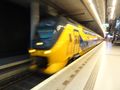
The first train, a VIRM towards Dordrecht.
At Dordrecht, changed onto this Spurt train towards Geldermalsen, operated by Qbuzz (who apparently also run trainzz)
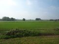
A beautiful day in Holland's green and pleasant land.
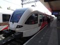
At Geldermalsen I changed onto this SLT towards Tiel.
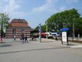
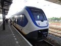
At Tiel station.
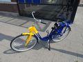
My hash bike for today.
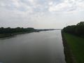
Crossing the Amsterdam-Rhine Canal (which, you guessed it, connects Amsterdam to the Rhine). Apparently it's one of the busiest shipping canals in the world, but today it was deserted.
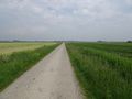
The hash road, the rather oddly named Rechtopweg ("upright road").
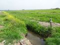
The hash field, with the blocked entrance and the drainage ditch.
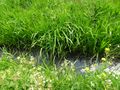
The hash is right about here.
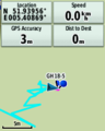
Precariously balancing myself on the edge I managed to reach it!
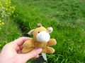
Lloyd happy to have reached another hash point.
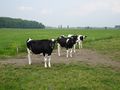
A bit further down the road, these cows seemed to be wondering what this odd visitor was doing there.
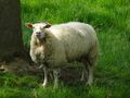
Spotted some more megafauna.


Achievements
FelixTheCat (talk) earned the Land geohash achievement
|