Difference between revisions of "2019-05-20 54 -2"
From Geohashing
imported>Angel |
imported>Fippe m (coordinates reached) |
||
| (One intermediate revision by one other user not shown) | |||
| Line 42: | Line 42: | ||
{{#vardefine:ribbonwidth|800px}} | {{#vardefine:ribbonwidth|800px}} | ||
<!-- Add any achievement ribbons you earned below, or remove this section --> | <!-- Add any achievement ribbons you earned below, or remove this section --> | ||
| − | |||
| − | |||
| − | |||
| − | |||
[[Category:Expeditions]] | [[Category:Expeditions]] | ||
[[Category:Expeditions with photos]] | [[Category:Expeditions with photos]] | ||
| − | |||
[[Category:Coordinates reached]] | [[Category:Coordinates reached]] | ||
| + | {{location|GB|ENG|LAN}} | ||
Latest revision as of 12:14, 27 July 2019
| Mon 20 May 2019 in 54,-2: 54.0306206, -2.7924388 geohashing.info google osm bing/os kml crox |
Location
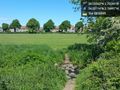
Barton Road playing fields, to the south of Lancaster.
Participants
Plans
Saw the flag on the map, thought I could fit it in as part of my daily exercise. Thought I could manage to get the Tron achievement, going via first Starbucks and then the podiatrist on the way home.
Expedition
Just as easy as I'd hoped; though my GPS app failed before making a complete loop on the map.
- Looks like Barton Road playing fields; shouldbe easy enough to reach. -- Angel (talk) @54.0348,-2.7871 11:45, 20 May 2019 (GMT+01:00)
Tracklog
Map online at: https://www.endomondo.com/users/3871875/workouts/1322189756
Photos
Nearly there :) @54.0311,-2.7900

360° view from the hash. No infobox, because Geohash Droid mangles panoramas.

Hash reached! @54.0306,-2.7924

