Difference between revisions of "2019-05-25 52 4"
imported>FelixTheCat (Created page with "{{subst:Expedition |lat = 52 |lon = 4 |date = 2019-05-25 }}") |
imported>FelixTheCat |
||
| Line 1: | Line 1: | ||
| − | |||
| − | |||
| − | |||
| − | |||
| − | |||
| − | |||
| − | |||
| − | |||
| − | |||
| − | |||
{{meetup graticule | {{meetup graticule | ||
| lat=52 | | lat=52 | ||
| Line 14: | Line 4: | ||
| date=2019-05-25 | | date=2019-05-25 | ||
}} | }} | ||
| − | |||
| − | |||
__NOTOC__ | __NOTOC__ | ||
== Location == | == Location == | ||
| − | + | Spaarnwoude recreational area, Velsen municipality, North Holland province. | |
== Participants == | == Participants == | ||
| − | + | [[User:FelixTheCat|FelixTheCat]] ([[User talk:FelixTheCat|talk]]) | |
| − | |||
| − | |||
| − | |||
| − | |||
== Expedition == | == Expedition == | ||
| − | + | Today was mouseover day, so a very good day for an expedition. Unfortunately I completely forgot about Towel Day and therefore set off without the obligatory towel... | |
| − | + | The hash was located in a grassy field in a recreational area on the outskirts of Amsterdam. I took a train to Haarlem and changed onto the Sprinter service to the north, getting off at Driehuis. There I rented a bike and rode to the destination. Once there it was easy to find the spot, since it was a wide open area with good GPS reception. I hung around for a while, taking pictures of the surroundings and experimenting with the zoom function on my camera to snap pictures of passing airplanes. Then I got back on the bike and explored the area a bit more, before riding on to visit the town of IJmuiden. There I visited the museum and watched the ships arriving and leaving the port. | |
| − | |||
== Photos == | == Photos == | ||
| − | |||
| − | |||
| − | |||
<gallery perrow="5"> | <gallery perrow="5"> | ||
| + | Image:2019-05-25_52_5_FelixTheCat_1.JPG | The train from Delft to Haarlem. | ||
| + | Image:2019-05-25_52_5_FelixTheCat_2.JPG | After changing in Haarlem, I got off at Driehuis (very small rural train station). | ||
| + | Image:2019-05-25_52_5_FelixTheCat_3.JPG | The OV-fiets system here is a bit different to what I've used before: the bikes are stored in large lockers, with a card-reading terminal in one of them. Swipe your card, press "Yes" to rent a bike, and one of the lockers is unlocked. | ||
| + | Image:2019-05-25_52_5_FelixTheCat_4.JPG | Quite a neat system, actually. | ||
| + | Image:2019-05-25_52_5_FelixTheCat_5.JPG | After about 15 minutes of cycling I reached the recreational area and parked the bike. | ||
| + | Image:2019-05-25_52_5_FelixTheCat_6.JPG | The hash field. According to the little sign, this is a "daytime campground, closing at sunset". Doesn't that defeat the whole idea of camping? | ||
| + | Image:2019-05-25_52_5_FelixTheCat_7.JPG | The hash is right here. | ||
| + | Image:2019-05-25_52_5_FelixTheCat_8.png | Nice zero distance at 2m accuracy. | ||
| + | Image:2019-05-25_52_5_FelixTheCat_9.JPG | Lloyd and Toettoet celebrating. | ||
| + | Image:2019-05-25_52_5_FelixTheCat_10.JPG | A pretty sharp picture I managed to take of a KLM 777 taking off from Schiphol. Note the condensation over the wing. | ||
| + | Image:2019-05-25_52_5_FelixTheCat_11.JPG | I climbed up this hill to get a nice view of the surrounding area. A hill in Holland, I hear you ask? Yes, it's an artificial one made from a former rubbish dump. | ||
| + | Image:2019-05-25_52_5_FelixTheCat_12.JPG | Another weird bit of landscaping, with lumps of debris from demolitions and two huge discs of concrete. | ||
</gallery> | </gallery> | ||
== Achievements == | == Achievements == | ||
{{#vardefine:ribbonwidth|800px}} | {{#vardefine:ribbonwidth|800px}} | ||
| − | + | {{Geohashing Day | |
| − | + | | latitude = 52 | |
| − | + | | longitude = 4 | |
| − | + | | year = 2019 | |
| − | + | | coorddate= 2019-05-25 | |
| − | + | | mouseover = true | |
| − | + | | name = [[User:FelixTheCat|FelixTheCat]] ([[User talk:FelixTheCat|talk]]) | |
| − | + | }} | |
| − | |||
| − | |||
| − | |||
| − | |||
| − | |||
| − | |||
| − | |||
| − | |||
[[Category:Expeditions]] | [[Category:Expeditions]] | ||
| − | |||
[[Category:Expeditions with photos]] | [[Category:Expeditions with photos]] | ||
| − | |||
| − | |||
| − | |||
| − | |||
| − | |||
| − | |||
| − | |||
[[Category:Coordinates reached]] | [[Category:Coordinates reached]] | ||
| − | |||
| − | |||
| − | |||
| − | |||
| − | |||
| − | |||
| − | |||
| − | |||
| − | |||
| − | |||
| − | |||
| − | |||
| − | |||
| − | |||
| − | |||
| − | |||
| − | |||
| − | |||
Revision as of 19:13, 25 May 2019
| Sat 25 May 2019 in 52,4: 52.4396596, 4.6754436 geohashing.info google osm bing/os kml crox |
Location
Spaarnwoude recreational area, Velsen municipality, North Holland province.
Participants
Expedition
Today was mouseover day, so a very good day for an expedition. Unfortunately I completely forgot about Towel Day and therefore set off without the obligatory towel...
The hash was located in a grassy field in a recreational area on the outskirts of Amsterdam. I took a train to Haarlem and changed onto the Sprinter service to the north, getting off at Driehuis. There I rented a bike and rode to the destination. Once there it was easy to find the spot, since it was a wide open area with good GPS reception. I hung around for a while, taking pictures of the surroundings and experimenting with the zoom function on my camera to snap pictures of passing airplanes. Then I got back on the bike and explored the area a bit more, before riding on to visit the town of IJmuiden. There I visited the museum and watched the ships arriving and leaving the port.
Photos
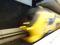
The train from Delft to Haarlem.
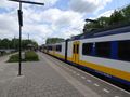
After changing in Haarlem, I got off at Driehuis (very small rural train station).
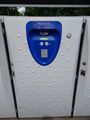
The OV-fiets system here is a bit different to what I've used before: the bikes are stored in large lockers, with a card-reading terminal in one of them. Swipe your card, press "Yes" to rent a bike, and one of the lockers is unlocked.
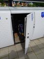
Quite a neat system, actually.
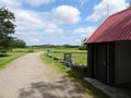
After about 15 minutes of cycling I reached the recreational area and parked the bike.
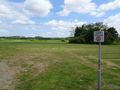
The hash field. According to the little sign, this is a "daytime campground, closing at sunset". Doesn't that defeat the whole idea of camping?
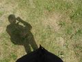
The hash is right here.
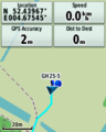
Nice zero distance at 2m accuracy.
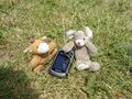
Lloyd and Toettoet celebrating.
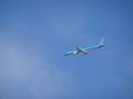
A pretty sharp picture I managed to take of a KLM 777 taking off from Schiphol. Note the condensation over the wing.
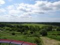
I climbed up this hill to get a nice view of the surrounding area. A hill in Holland, I hear you ask? Yes, it's an artificial one made from a former rubbish dump.
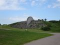
Another weird bit of landscaping, with lumps of debris from demolitions and two huge discs of concrete.


Achievements
FelixTheCat (talk) earned the 2019 Mouse Over Day achievement
|