Difference between revisions of "2019-05-26 40 -74"
imported>Zubenelgenubi (Created page with "{{meetup graticule | lat=40 | lon=-74 | date=2019-05-26 }} <!-- edit as necessary --> __NOTOC__ == Participants == *Zubenelgenubi == Plans == The fir...") |
imported>FippeBot m (Location) |
||
| Line 30: | Line 30: | ||
[[Category:Expeditions with photos]] | [[Category:Expeditions with photos]] | ||
[[Category:Coordinates reached]] | [[Category:Coordinates reached]] | ||
| + | {{location|US|NJ|MI}} | ||
Latest revision as of 12:38, 14 July 2019
| Sun 26 May 2019 in 40,-74: 40.4362932, -74.3656433 geohashing.info google osm bing/os kml crox |
Participants
Plans
The first time I targeted a geohash for a bike ride in over a year was for coordinates just off the sidewalk in what was clearly a rich section of South River.
Expedition
The southern approach was via River Road, a name which (in the absence of canyons or steep valleys) implies that the road will be fairly flat. It is not, veering well off the river and towering above it. I found no trouble in Heritage Landing, simply stepping off onto the sidewalk just past the coordinates.
I went on into Sayreville for awhile before turning home. One good thing about the coordinates was that although I did get rained on a little going back through South River, I would have gotten rather more rain at home or if I had gone to my planned original destination.
Photos
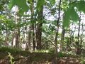
River Road towering over the river
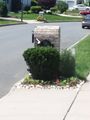
At the hash point, 38 Charter Dr.
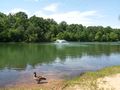
Two blocks away at Edward Grekoski Park. Right along the river, but set around a pond that is presumably less muddy or flood-prone.
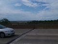
Edgeboro Landfill from the bridge over South River

Me on the bridge over South River


