Difference between revisions of "2019-05-26 52 9"
imported>GeorgDerReisende (new report) |
imported>GeorgDerReisende (expedition report for Hagenburg-Altenhagen) |
||
| Line 1: | Line 1: | ||
| + | [[Image:{{{image|2019-05-26 52 9 GeorgDerReisende 0001.jpg}}}|thumb|left]] | ||
| − | |||
| − | |||
| − | |||
| − | |||
| − | |||
| − | |||
| − | |||
| − | |||
| − | |||
{{meetup graticule | {{meetup graticule | ||
| lat=52 | | lat=52 | ||
| Line 19: | Line 11: | ||
== Location == | == Location == | ||
| − | + | ||
| + | The hash lay on a fieldway east of Hagenburg-Altenhagen. | ||
== Participants == | == Participants == | ||
| − | + | ||
| − | + | [[User:GeorgDerReisende|GeorgDerReisende]] | |
== Plans == | == Plans == | ||
| − | + | ||
| + | Today was an election day for the European Parliament. So my plans were: Voting and geohashing. | ||
== Expedition == | == Expedition == | ||
| − | |||
| − | + | At first I went to the voting office and voted. Then I traveled to Altenhagen and walked to the hash. While I actually have no functional GPS I calculated the geohash on the map. The map told me something about 125.2 meters to go from the cycle path and I converted this to 157 steps. I walked along the fieldway and after 157 steps I mentioned to be at the hash. I wrote a marker there and took the usual photos. Then I traveled home. | |
| − | |||
== Photos == | == Photos == | ||
| − | |||
| − | |||
| − | |||
<gallery perrow="5"> | <gallery perrow="5"> | ||
| + | 2019-05-26 52 9 GeorgDerReisende 8829.jpg | the Fasanenhofschule is the voting office for the Fasanenhof quarter | ||
| + | 2019-05-26 52 9 GeorgDerReisende 8845.jpg | with this bus I traveled to Altenhagen, but without a bike | ||
| + | 2019-05-26 52 9 GeorgDerReisende 8883.jpg | this is the fieldway to the hash, 157 steps to go | ||
| + | 2019-05-26 52 9 GeorgDerReisende 8888.jpg | some words on the way | ||
| + | 2019-05-26 52 9 GeorgDerReisende 8889.jpg | looking north | ||
| + | 2019-05-26 52 9 GeorgDerReisende 8890.jpg | looking east | ||
| + | 2019-05-26 52 9 GeorgDerReisende 8891.jpg | looking south | ||
| + | 2019-05-26 52 9 GeorgDerReisende 8892.jpg | looking west | ||
| + | 2019-05-26 52 9 GeorgDerReisende 8893.jpg | the geohasher | ||
</gallery> | </gallery> | ||
| Line 45: | Line 43: | ||
<!-- Add any achievement ribbons you earned below, or remove this section --> | <!-- Add any achievement ribbons you earned below, or remove this section --> | ||
| − | + | {{gratuitous ribbon | color = white | icon = Voting.png | latitude = 52 | longitude = 9 | date = 2019-05-26 | achievement = Democracy Geohash Achievement | description = going voting on the way to the | name = GeorgDerReisende }} | |
| − | |||
| − | |||
| − | + | [[Category:Expeditions]] | |
| − | + | [[Category:Expeditions with photos]] | |
| − | |||
| − | [[Category: | ||
| − | |||
| − | |||
| − | |||
| − | |||
| − | |||
| − | |||
| − | |||
| − | |||
[[Category:Expedition without GPS]] | [[Category:Expedition without GPS]] | ||
| − | |||
| − | |||
| − | |||
| − | |||
| − | |||
| − | |||
| + | {{location|DE|NI|SHG}} | ||
| − | + | [[Category:Coordinates reached]] | |
| − | [[Category:Coordinates | ||
| − | |||
| − | |||
| − | |||
| − | |||
| − | |||
| − | |||
| − | |||
| − | |||
| − | |||
| − | |||
| − | |||
| − | |||
| − | |||
| − | |||
Latest revision as of 14:54, 27 May 2019

| Sun 26 May 2019 in 52,9: 52.4362932, 9.3656433 geohashing.info google osm bing/os kml crox |
Location
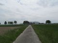
The hash lay on a fieldway east of Hagenburg-Altenhagen.
Participants
Plans
Today was an election day for the European Parliament. So my plans were: Voting and geohashing.
Expedition
At first I went to the voting office and voted. Then I traveled to Altenhagen and walked to the hash. While I actually have no functional GPS I calculated the geohash on the map. The map told me something about 125.2 meters to go from the cycle path and I converted this to 157 steps. I walked along the fieldway and after 157 steps I mentioned to be at the hash. I wrote a marker there and took the usual photos. Then I traveled home.
Photos
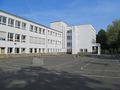
the Fasanenhofschule is the voting office for the Fasanenhof quarter
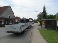
with this bus I traveled to Altenhagen, but without a bike
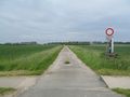
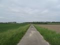
this is the fieldway to the hash, 157 steps to go
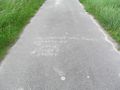
some words on the way
looking north
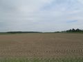
looking east
looking south
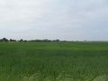
looking west
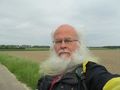
the geohasher


Achievements
GeorgDerReisende earned the Democracy Geohash Achievement
|