imported>GeorgDerReisende |
imported>GeorgDerReisende |
| Line 1: |
Line 1: |
| | + | [[Image:{{{image|2019-05-31 50 8 GeorgDerReisende 0001.jpg}}}|thumb|left]] |
| | | | |
| − | <!-- If you did not specify these parameters in the template, please substitute appropriate values for IMAGE, LAT, LON, and DATE (YYYY-MM-DD format)
| |
| − |
| |
| − | [[Image:{{{image|IMAGE}}}|thumb|left]]
| |
| − |
| |
| − | Remove this section if you don't want an image at the top (left) of your report. You should remove the "Image:" or "File:"
| |
| − | tag from your image file name, and replace the all upper-case word IMAGE in the above line.
| |
| − |
| |
| − | And DON'T FORGET to add your expedition and the best photo you took to the gallery on the Main Page! We'd love to read your report, but that means we first have to discover it! :)
| |
| − | -->
| |
| | {{meetup graticule | | {{meetup graticule |
| | | lat=50 | | | lat=50 |
| Line 19: |
Line 11: |
| | | | |
| | == Location == | | == Location == |
| − | <!-- where you've surveyed the hash to be -->
| + | |
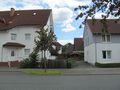
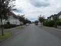
| | + | The hash lay in the Greizer Straße in Gießen-Wieseck. |
| | | | |
| | == Participants == | | == Participants == |
| − | <!-- who attended: If you link to your wiki user name in this section, your expedition will be picked up by the various statistics generated for geohashing. You may use three tildes ~ as a shortcut to automatically insert the user signature of the account you are editing with.
| + | |
| − | -->
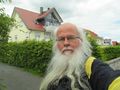
| + | [[User:GeorgDerReisende|GeorgDerReisende]] |
| | | | |
| | == Plans == | | == Plans == |
| − | <!-- what were the original plans -->
| + | |
| | + | Going there by public transport, that's all. |
| | | | |
| | == Expedition == | | == Expedition == |
| − | <!-- how it all turned out. your narrative goes here. -->
| |
| | | | |
| − | == Tracklog ==
| + | Nothing to tell. Arriving there, a small dance on the street. |
| − | <!-- if your GPS device keeps a log, you may post a link here -->
| |
| | | | |
| | == Photos == | | == Photos == |
| − | <!-- Insert pictures between the gallery tags using the following format:
| |
| − | Image:2012-##-## ## ## Alpha.jpg | Witty Comment
| |
| − | -->
| |
| | <gallery perrow="5"> | | <gallery perrow="5"> |
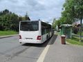
| | + | 2019-05-31 50 8 GeorgDerReisende 9419.jpg | arrived by bus |
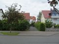
| | + | 2019-05-31 50 8 GeorgDerReisende 9424.jpg | entrance to No 12 |
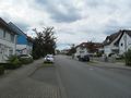
| | + | 2019-05-31 50 8 GeorgDerReisende 9425.jpg | looking west |
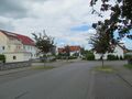
| | + | 2019-05-31 50 8 GeorgDerReisende 9426.jpg | looking east |
| | + | 2019-05-31 50 8 GeorgDerReisende 9427.jpg | looking south |
| | + | 2019-05-31 50 8 GeorgDerReisende 9428.jpg | the geohasher |
| | + | 2019-05-31 50 8 GeorgDerReisende 9429.jpg | the geohash in the middle of the street |
| | </gallery> | | </gallery> |
| | | | |
| − | == Achievements ==
| + | [[Category:Expeditions]] |
| − | {{#vardefine:ribbonwidth|800px}}
| |
| − | <!-- Add any achievement ribbons you earned below, or remove this section -->
| |
| | | | |
| − | <!-- =============== USEFUL CATEGORIES FOLLOW ================
| + | [[Category:Expeditions with photos]] |
| − | Delete the next line ONLY if you have chosen the appropriate categories below. If you are unsure, don't worry. People will read your report and help you with the classification. -->
| |
| − | [[Category:New report]] | |
| | | | |
| − | <!-- ==REQUEST FOR TWITTER BOT== Please leave either the New report or the Expedition planning category in as long as you work on it. This helps the twitter bot a lot with announcing the right outcome at the right moment. -->
| + | [[Category:Expedition without GPS]] |
| | | | |
| − | <!-- Potential categories. Please include all the ones appropriate to your expedition -->
| + | {{location|DE|HE|GI}} |
| − | <!-- If this is a planning page:
| |
| − | [[Category:Expedition planning]]
| |
| − | -->
| |
| | | | |
| − | <!-- If all those plans are never acted upon, change [[Category:Expedition planning]] to [[Category:Not reached - Did not attempt]]. -->
| |
| − |
| |
| − | <!-- An actual expedition:
| |
| − | [[Category:Expeditions]]
| |
| − | -- and one or more of --
| |
| − | [[Category:Expeditions with photos]]
| |
| − | [[Category:Expeditions with videos]]
| |
| − | [[Category:Expedition without GPS]]
| |
| − | -- Tag your location: --
| |
| − | {{location}}
| |
| − | -->
| |
| − |
| |
| − | <!-- if you reached your coords:
| |
| | [[Category:Coordinates reached]] | | [[Category:Coordinates reached]] |
| − |
| |
| − |
| |
| − | --><!-- or if you failed :(
| |
| − | [[Category:Coordinates not reached]]
| |
| − | -- and a reason --
| |
| − | When there is a natural obstacle between you and the target:
| |
| − | [[Category:Not reached - Mother Nature]]
| |
| − |
| |
| − | When there is a man-made obstacle between you and the target:
| |
| − | [[Category:Not reached - No public access]]
| |
| − |
| |
| − | When you failed get your GPS, car, bike or such to work:
| |
| − | [[Category:Not reached - Technology]]
| |
| − |
| |
| − | When you went to an alternate location instead of the actual geohash:
| |
| − | [[Category:Not reached - Attended alternate location]]
| |
| − |
| |
| − | (Don't forget to delete this final close comment marker) -->
| |