Difference between revisions of "2019-06-04 62 29"
imported>Kripakko |
|||
| (2 intermediate revisions by 2 users not shown) | |||
| Line 1: | Line 1: | ||
| − | |||
| − | |||
| − | |||
| − | |||
| − | |||
| − | |||
| − | |||
| − | |||
| − | |||
| − | |||
{{meetup graticule | {{meetup graticule | ||
| lat=62 | | lat=62 | ||
| Line 45: | Line 35: | ||
== Photos == | == Photos == | ||
| − | |||
| − | |||
| − | |||
<gallery perrow="5"> | <gallery perrow="5"> | ||
| + | Image:2019-06-04_62_29_01-gpsr.png | Screenshots of my GPS receiver. | ||
| + | Image:2019-06-04_62_29_02-house.jpg | The house near the hashpoint. | ||
| + | Image:2019-06-04_62_29_03-mosquito.jpg | Mosquitoes everywhere. | ||
| + | Image:2019-06-04_62_29_04-selfie1.jpg | First selfie attempt: too dark. | ||
| + | Image:2019-06-04_62_29_05-selfie2.jpg | Second selfie attempt with flash: out of focus. | ||
| + | Image:2019-06-04_62_29_06-sunrise1.jpg | The sun is rising somewhere in that direction. | ||
| + | Image:2019-06-04_62_29_07-sunrise2.jpg | The sun has risen... apparently. | ||
| + | Image:2019-06-04_62_29_08-mushroom.jpg | A mushroom growing in an abnormal time of year. | ||
| + | Image:2019-06-04_62_29_09-cat.jpg | Cat encounter on the way home. | ||
</gallery> | </gallery> | ||
| Line 54: | Line 50: | ||
{{#vardefine:ribbonwidth|800px}} | {{#vardefine:ribbonwidth|800px}} | ||
{{land geohash | latitude = 62 | longitude = 29 | date = 2019-06-04 | name = Kripakko }} | {{land geohash | latitude = 62 | longitude = 29 | date = 2019-06-04 | name = Kripakko }} | ||
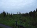
| − | {{Bicycle geohash | latitude = 62 | longitude = 29 | date = 2019-06-04 | name = Kripakko | distance = | + | {{Bicycle geohash | latitude = 62 | longitude = 29 | date = 2019-06-04 | name = Kripakko | distance = 47.6 km | bothways = true }} |
{{Sunrise geohash | latitude = 62 | longitude = 29 | date = 2019-06-04 | name = Kripakko }} | {{Sunrise geohash | latitude = 62 | longitude = 29 | date = 2019-06-04 | name = Kripakko }} | ||
| Line 60: | Line 56: | ||
[[Category:Expeditions with photos]] | [[Category:Expeditions with photos]] | ||
[[Category:Coordinates reached]] | [[Category:Coordinates reached]] | ||
| + | {{location|FI|13}} | ||
Latest revision as of 18:04, 30 March 2020
| Tue 4 Jun 2019 in 62,29: 62.4520814, 29.8719524 geohashing.info google osm bing/os kml crox |
Location
In a forest near some houses and close to the shore of lake Pyhäselkä.
Participants
Plans
The location seems to be easily accessible, and I will cycle there. I have two possible plans:
- Go there early and be there during the sunrise, at 3:16 (or 2:15 local mean solar time). As I am writing this, it is just past 1 o'clock and I feel like I cannot sleep anyway. However, the weather is rainy, and I would not get to see the sun.
- Go there in the evening after work when the weather should be nice.
Update half an hour later: The rain has calmed down. I will do the first plan.
Expedition
I left from home at about 2 o'clock. The sky was covered in thick clouds, and because of that it was still quite dark outside. And like I mentioned, it was raining occasionally too. When I cycled towards the hashpoint, visibility improved gradually as the moment of sunrise got closer. Eventually, I reached the end of Huvilatie road and had only 120 metres to walk. I reached the hashpoint at 3:12, a few minutes before sunrise. However, due to the thick clouds it was impossible to see the actual sunrise. I tried to take some pictures, noticed that there was not enough light for my photographing setup, and left at 3:24. All in all, this was quite an uneventful expedition.
Sunrise geohash
The theoretical sunrise time is:
- 3:16 according to suncalc.org and XEphem (taking the atmosphere into account)
- 3:17 according to timeanddate.com and sunrisesunsetmap.com
- 3:20 according to my Garmin eTrex 30.
I was at the hashpoint from 3:12 to 3:24, so regardless of which time is correct, I was definitely there during sunrise.
Photos
Screenshots of my GPS receiver.
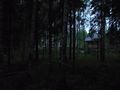
The house near the hashpoint.
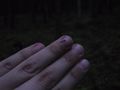
Mosquitoes everywhere.
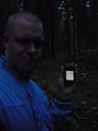
First selfie attempt: too dark.
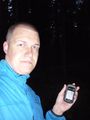
Second selfie attempt with flash: out of focus.
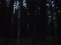
The sun is rising somewhere in that direction.
The sun has risen... apparently.
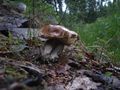
A mushroom growing in an abnormal time of year.
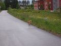
Cat encounter on the way home.


Achievements
Kripakko earned the Land geohash achievement
|
Kripakko earned the Bicycle geohash achievement
|
Kripakko earned the Sunrise Geohash Achievement
|