Difference between revisions of "2019-06-13 46 -122"
imported>Michael5000 m (→Location) |
imported>FippeBot m (Location) |
||
| (One intermediate revision by one other user not shown) | |||
| Line 23: | Line 23: | ||
== Participants == | == Participants == | ||
| − | + | ||
| − | + | *[[User:Michael5000|Michael5000]] | |
== Plans == | == Plans == | ||
| − | + | ||
| + | I saw this one in the morning, and it was attractive because it fell in the little bit of Oregon in the southwest of the Mt. St. Helens graticule. Also, it seemed like it would be fun to relax with a drive after interviewing for a new position at work. I figured I'd also go for the Formal Wear achievement, although at a minimal standard as I don't work in a very formal industry. | ||
== Expedition == | == Expedition == | ||
| − | |||
| − | + | I crossed into Washington on I-205, drove up to Longview on I-5, then crossed the Columbia back into Oregon and started south on U.S. 30. Trojan Park is the former location of the Trojan Nuclear Power Plant, which always seems a little alarming, but it's quiet and peaceful and you can watch people fish in the old cooling ponds. The hashpoint itself was on a large playing field where a bunch of high school kids were playing Ultimate. It was sunny and cool, and lovely, but there was no particular reason to stick around and I was hungry, so I started back south. | |
| − | |||
== Photos == | == Photos == | ||
| − | + | ||
| − | |||
| − | |||
<gallery perrow="5"> | <gallery perrow="5"> | ||
| + | File:2019-06-13 46 -122 sign.jpg|Welcome to the park! | ||
| + | File:2019-06-13 46 -122 field.jpg|The field with the kids playing ultimate. | ||
| + | File:2019-06-13 46 -122 me.jpg|Me, at the hashpoint. | ||
</gallery> | </gallery> | ||
== Achievements == | == Achievements == | ||
| − | |||
| − | |||
| − | |||
| − | |||
| − | |||
| − | |||
| − | |||
| − | |||
| − | |||
| − | |||
| − | |||
| − | |||
| − | |||
| − | |||
| − | |||
| − | |||
| − | |||
[[Category:Expeditions]] | [[Category:Expeditions]] | ||
| − | |||
[[Category:Expeditions with photos]] | [[Category:Expeditions with photos]] | ||
| − | |||
| − | |||
| − | |||
| − | |||
| − | |||
| − | |||
| − | |||
[[Category:Coordinates reached]] | [[Category:Coordinates reached]] | ||
| + | [[File:2019-06-13 46 -122 map.JPG]] | ||
| + | *My 4th Columbia County expedition | ||
| + | *My 3rd expedition to the Mt. St. Helens graticule | ||
| + | {{Formal attire | ||
| − | - | + | | latitude = 46 |
| − | + | | longitude = -122 | |
| − | + | | date = 2019-06-13 | |
| − | + | | name = Michael5000 | |
| − | + | | image = 2019-06-13 46 -122 me.jpg | |
| − | |||
| − | |||
| − | |||
| − | |||
| − | |||
| − | |||
| − | |||
| − | |||
| − | |||
| − | + | }} | |
| + | {{location|US|OR|CL}} | ||
Latest revision as of 12:41, 14 July 2019
| Thu 13 Jun 2019 in 46,-122: 46.0342720, -122.8864567 geohashing.info google osm bing/os kml crox |
Location
On a field in Trojan Park, just off of U.S. Highway 30 in the Oregon corner of the graticule.
Participants
Plans
I saw this one in the morning, and it was attractive because it fell in the little bit of Oregon in the southwest of the Mt. St. Helens graticule. Also, it seemed like it would be fun to relax with a drive after interviewing for a new position at work. I figured I'd also go for the Formal Wear achievement, although at a minimal standard as I don't work in a very formal industry.
Expedition
I crossed into Washington on I-205, drove up to Longview on I-5, then crossed the Columbia back into Oregon and started south on U.S. 30. Trojan Park is the former location of the Trojan Nuclear Power Plant, which always seems a little alarming, but it's quiet and peaceful and you can watch people fish in the old cooling ponds. The hashpoint itself was on a large playing field where a bunch of high school kids were playing Ultimate. It was sunny and cool, and lovely, but there was no particular reason to stick around and I was hungry, so I started back south.
Photos
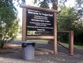
Welcome to the park!
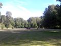
The field with the kids playing ultimate.

Me, at the hashpoint.


Achievements

- My 4th Columbia County expedition
- My 3rd expedition to the Mt. St. Helens graticule
Michael5000 earned the Formal attire achievement
|