Difference between revisions of "2019-06-14 51 10"
From Geohashing
imported>GeorgDerReisende (new report) |
imported>GeorgDerReisende (expedition report for Steinbach) |
||
| Line 1: | Line 1: | ||
| + | [[Image:{{{image|2019-06-14 51 10 GeorgDerReisende 0001.jpg}}}|thumb|left]] | ||
| − | |||
| − | |||
| − | |||
| − | |||
| − | |||
| − | |||
| − | |||
| − | |||
| − | |||
{{meetup graticule | {{meetup graticule | ||
| lat=51 | | lat=51 | ||
| Line 19: | Line 11: | ||
== Location == | == Location == | ||
| − | + | ||
| + | The hash lay at a tree southeast of Steinbach in the Eichsfeld. | ||
== Participants == | == Participants == | ||
| − | + | ||
| − | + | [[User:GeorgDerReisende|GeorgDerReisende]] | |
== Plans == | == Plans == | ||
| − | + | ||
| + | Public transport and walking. | ||
== Expedition == | == Expedition == | ||
| − | |||
| − | + | I left home at 8:30 and with a bus, two trains and another two buses I arrived at Steinbach. There I walked through the village and to the hash. I found it near the stackyard at the small tree. Then I walked to Wingerode for traveling home. On the way I was watched by a hunting bird and I watched ants rescuing their larvas after a heavy rain. | |
| − | |||
== Photos == | == Photos == | ||
| − | |||
| − | |||
| − | |||
<gallery perrow="5"> | <gallery perrow="5"> | ||
| + | 2019-06-14 51 10 GeorgDerReisende 0559.jpg | arrived at Steinbach | ||
| + | 2019-06-14 51 10 GeorgDerReisende 0612.jpg | the way to the hash | ||
| + | 2019-06-14 51 10 GeorgDerReisende 0615.jpg | the hash at the tree | ||
| + | 2019-06-14 51 10 GeorgDerReisende 0618.jpg | looking west | ||
| + | 2019-06-14 51 10 GeorgDerReisende 0619.jpg | looking north | ||
| + | 2019-06-14 51 10 GeorgDerReisende 0620.jpg | looking east | ||
| + | 2019-06-14 51 10 GeorgDerReisende 0621.jpg | looking south | ||
| + | 2019-06-14 51 10 GeorgDerReisende 0622.jpg | the geohasher | ||
| + | 2019-06-14 51 10 GeorgDerReisende 0678.jpg | I was watched by a hunting bird | ||
| + | 2019-06-14 51 10 GeorgDerReisende 0689.jpg | I watched ants, rescuing their larvas | ||
</gallery> | </gallery> | ||
| − | + | [[Category:Expeditions]] | |
| − | |||
| − | |||
| − | + | [[Category:Expeditions with photos]] | |
| − | |||
| − | [[Category: | ||
| − | + | [[Category:Expedition without GPS]] | |
| − | + | {{location|DE|TH|EIC}} | |
| − | |||
| − | |||
| − | |||
| − | |||
| − | |||
| − | |||
| − | |||
| − | |||
| − | |||
| − | |||
| − | |||
| − | |||
| − | |||
| − | |||
| − | |||
| − | |||
[[Category:Coordinates reached]] | [[Category:Coordinates reached]] | ||
| − | |||
| − | |||
| − | |||
| − | |||
| − | |||
| − | |||
| − | |||
| − | |||
| − | |||
| − | |||
| − | |||
| − | |||
| − | |||
| − | |||
| − | |||
| − | |||
| − | |||
| − | |||
Latest revision as of 19:38, 14 June 2019

| Fri 14 Jun 2019 in 51,10: 51.4124658, 10.2263416 geohashing.info google osm bing/os kml crox |
Location
The hash lay at a tree southeast of Steinbach in the Eichsfeld.
Participants
Plans
Public transport and walking.
Expedition
I left home at 8:30 and with a bus, two trains and another two buses I arrived at Steinbach. There I walked through the village and to the hash. I found it near the stackyard at the small tree. Then I walked to Wingerode for traveling home. On the way I was watched by a hunting bird and I watched ants rescuing their larvas after a heavy rain.
Photos
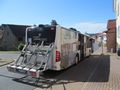
arrived at Steinbach
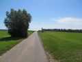
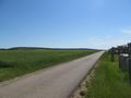
the way to the hash
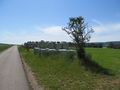
the hash at the tree
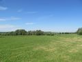
looking west
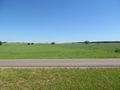
looking north
looking east
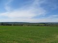
looking south
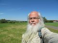
the geohasher
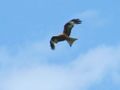
I was watched by a hunting bird
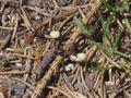
I watched ants, rescuing their larvas


