Difference between revisions of "2019-06-27 48 8"
From Geohashing
imported>Kellerkind (Created page with "{{meetup graticule | lat=48 | lon=8 | date=2019-06-27 }} __NOTOC__ == Location == Next to a soccer field. == Participants == *Kellerkind and family ==...") |
imported>FippeBot m (Location) |
||
| (One intermediate revision by one other user not shown) | |||
| Line 27: | Line 27: | ||
== Photos == | == Photos == | ||
| − | <gallery perrow=" | + | <gallery perrow="5"> |
Image:2019-06-27_48-8_0.jpg | | Image:2019-06-27_48-8_0.jpg | | ||
Image:2019-06-27_48-8_1.jpg | a "path" | Image:2019-06-27_48-8_1.jpg | a "path" | ||
| Line 61: | Line 61: | ||
[[Category:Expeditions with photos]] | [[Category:Expeditions with photos]] | ||
[[Category:Coordinates reached]] | [[Category:Coordinates reached]] | ||
| + | {{location|DE|BW|KA|city=true}} | ||
Latest revision as of 12:45, 14 July 2019
| Thu 27 Jun 2019 in 48,8: 48.9905594, 8.4434269 geohashing.info google osm bing/os kml crox |
Location
Next to a soccer field.
Participants
- Kellerkind and family
Plans
Try to get a Tron achievement and eat at a local restaurant. I had to convince my dad that there is indeed a path along the soccer field that goes right by the geohash. He must've thought that Google Maps knows about every little path. It was already in OpenStreetMap, which he didn't bother to check ;)
Expedition
We carefully avoided crossing our own path and managed to find the geohash without walking in circles. Afterwards, we ate dinner at an italian restaurant (La Terrazza).
Tracklog
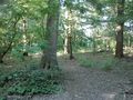
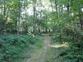
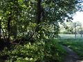
Photos
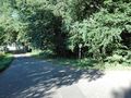
a "path"
same path
hash is to the left
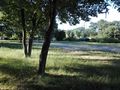
view of the soccer field


Achievements
This user earned the Land geohash achievement
|
This user earned the Bicycle geohash achievement
|
This user earned the Tron achievement
|