Difference between revisions of "2019-07-07 47 -122"
From Geohashing
imported>Thomcat ([retro picture]Intersection & bridge [http://www.openstreetmap.org/?lat=47.75028930&lon=-122.21168150&zoom=16&layers=B000FTF @47.7503,-122.2117]) |
imported>Thomcat ([retro picture]Geohasher [http://www.openstreetmap.org/?lat=47.75059460&lon=-122.21084770&zoom=16&layers=B000FTF @47.7506,-122.2108]) |
||
| Line 47: | Line 47: | ||
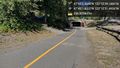
Image:2019-07-07_47_-122_thomcat_1564443372916.jpg|Intersection & bridge [http://www.openstreetmap.org/?lat=47.75028930&lon=-122.21168150&zoom=16&layers=B000FTF @47.7503,-122.2117] | Image:2019-07-07_47_-122_thomcat_1564443372916.jpg|Intersection & bridge [http://www.openstreetmap.org/?lat=47.75028930&lon=-122.21168150&zoom=16&layers=B000FTF @47.7503,-122.2117] | ||
| + | |||
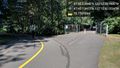
| + | Image:2019-07-07_47_-122_thomcat_1564443670353.jpg|Geohasher [http://www.openstreetmap.org/?lat=47.75059460&lon=-122.21084770&zoom=16&layers=B000FTF @47.7506,-122.2108] | ||
</gallery> | </gallery> | ||
Revision as of 23:41, 29 July 2019
| Sun 7 Jul 2019 in Seattle: 47.7506291, -122.2108833 geohashing.info google osm bing/os kml crox |
Location
Near the junction of the Burke-Gilman Trail and Sammamish River Trail in Bothell.
Participants
Plans
(Retro) Going to stop by after work and check out the site.
Expedition
=== SubRosa We found it! Our first geohash : ) Am I supposed to like post a selfie taken at the site or something?
=== Thomcat
Tracklog
Photos
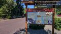
Red Brick Road @47.7503,-122.2127
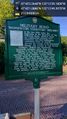
Military road marker @47.7503,-122.2137
Burke Gilman tunnel @47.7505,-122.2143
Intersection & bridge @47.7503,-122.2117

Geohasher @47.7506,-122.2108


