Difference between revisions of "2019-07-27 42 -83"
imported>Ipswichb (Created page with "{{meetup graticule | lat=42 | lon=-83 | date=2019-07-27 }} <!-- edit as necessary --> __NOTOC__ == Location == Just off a dirt road nearby Howell, close to someone's backya...") |
imported>Ipswichb m |
||
| Line 21: | Line 21: | ||
== Photos == | == Photos == | ||
| − | + | <gallery> | |
| + | 7-27-19_Hashpoint.jpg | As close to the hashpoint as I could get. The actual point is probably within this picture just a little further down the trail. | ||
| + | 7-27-19 Proof.png | Proof | ||
| + | </gallery> | ||
| + | |||
[[Category:New report]] | [[Category:New report]] | ||
Revision as of 17:01, 28 July 2019
| Sat 27 Jul 2019 in 42,-83: 42.6005450, -83.8421550 geohashing.info google osm bing/os kml crox |
Location
Just off a dirt road nearby Howell, close to someone's backyard.
Participants
Plans
I planned on parking as close to the hashpoint as I could, probably in the little pulloff on the side of the road right by the path you can see on Google Maps. I knew I probably couldn't get the actual hashpoint itself (that would be invading a little too much on someone's personal space) but I hoped I could get close enough to call it a success (in my opinion, within ten meters is a successful expedition).
Expedition
It worked just about as I planned! I parked in the pulloff and went off on the short walk through the field. I immediately saw that it would indeed be impossible to stand on the hashpoint itself, but I was able to get close enough to call it a successful expedition.
Photos
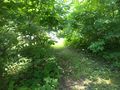
As close to the hashpoint as I could get. The actual point is probably within this picture just a little further down the trail.
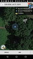
Proof

