Difference between revisions of "2019-08-06 53 9"
Gumbledalf (talk | contribs) (Created page with "{{meetup graticule|lat=53|lon=9|date=2019-08-06}} ==Location== on a field only 140 m from the Norderstedt [https://en.wikipedia.org/wiki/Low-Frequency_Array_(LOFAR) LOFAR tel...") |
Leidenfrost (talk | contribs) m (→Photos) |
||
| (2 intermediate revisions by the same user not shown) | |||
| Line 11: | Line 11: | ||
I know that [[User:Leidenfrost|Leidenfrost]] went there while I was in Iceland. I might try to convince him to write a report sometime. Would've loved to go myself, especially because I'm very interested in astronomy. | I know that [[User:Leidenfrost|Leidenfrost]] went there while I was in Iceland. I might try to convince him to write a report sometime. Would've loved to go myself, especially because I'm very interested in astronomy. | ||
| + | |||
| + | ===[[User:Leidenfrost|Leidenfrost]] in 2022:=== | ||
| + | |||
| + | Rather uninteresting hash, I checked the coordinates the day before, and planned the route. On the day of, I took the ''A2'' to ''Norderstedt-Mitte'', and biked for ~10 minutes until I reached the road near the hash. I left my bike near the road, and went into the field, noting that a few meters from the hash, it looked like another person may have gone there. I took the required pictures, and took the same way back home. This was the first of three consecutive hashes. | ||
| + | |||
| + | Disppointing π π π, I did not even know about the LOFAR at the location. | ||
| + | |||
| + | ==Photos== | ||
| + | <gallery> | ||
| + | File:2019-08-06 53 9 two fields.jpg | the location | ||
| + | File:2019-08-06 53 9 tracks.jpg | suggests there may have been a ninja | ||
| + | File:2019-08-06 53 9 view from hash.jpg | not the worst view from the hash | ||
| + | File:2019-08-06 53 9 feet.jpg |standing on the hash | ||
| + | File:2019-08-06 53 9 coords.jpg |proof | ||
| + | File:2019-08-06 53 9 google.jpg |proof2 | ||
| + | File:2019-08-06 53 9 pano from street.jpg |panorama taken from the street | ||
| + | </gallery> | ||
==Achievements== | ==Achievements== | ||
| − | + | {{land geohash | |
| + | |||
| + | | latitude = 53 | ||
| + | | longitude = 9 | ||
| + | | date = 2019-08-06 | ||
| + | | name = [[User:Leidenfrost|Leidenfrost]] | ||
| + | | image = | ||
| + | }} | ||
| + | {{Public transport geohash | ||
| + | |||
| + | | latitude = 53 | ||
| + | | longitude = 9 | ||
| + | | date = 2019-08-06 | ||
| + | | name = [[User:Leidenfrost|Leidenfrost]] | ||
| + | | busline = A2 | ||
| + | | image = | ||
| + | }} | ||
| + | {{Last Man Standing | ||
| + | |||
| + | | latitude = 53 | ||
| + | | longitude = 9 | ||
| + | | date = 2019-08-06 | ||
| + | | name = [[User:Leidenfrost|Leidenfrost]] | ||
| + | | image = | ||
| + | }} | ||
__NOTOC__ | __NOTOC__ | ||
Latest revision as of 14:09, 22 February 2024
| Tue 6 Aug 2019 in 53,9: 53.6985614, 9.9661041 geohashing.info google osm bing/os kml crox |
Location
on a field only 140 m from the Norderstedt LOFAR telescope station, one of only 29 world-wide
Participants
Expedition
Log from π π π:
I know that Leidenfrost went there while I was in Iceland. I might try to convince him to write a report sometime. Would've loved to go myself, especially because I'm very interested in astronomy.
Leidenfrost in 2022:
Rather uninteresting hash, I checked the coordinates the day before, and planned the route. On the day of, I took the A2 to Norderstedt-Mitte, and biked for ~10 minutes until I reached the road near the hash. I left my bike near the road, and went into the field, noting that a few meters from the hash, it looked like another person may have gone there. I took the required pictures, and took the same way back home. This was the first of three consecutive hashes.
Disppointing π π π, I did not even know about the LOFAR at the location.
Photos
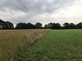
the location
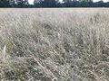
suggests there may have been a ninja
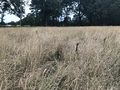
not the worst view from the hash
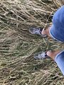
standing on the hash
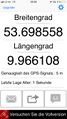
proof
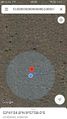
proof2
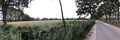
panorama taken from the street


Achievements
Leidenfrost earned the Land geohash achievement
|
Leidenfrost earned the Public transport geohash achievement
|
Leidenfrost earned the Last man standing achievement
|