Difference between revisions of "2019-08-07 53 9"
From Geohashing
Gumbledalf (talk | contribs) (Created page with "{{meetup graticule|lat=53|lon=9|date=2019-08-07}} ==Location== in a field of 3 m high corn in Alveslohe ==Participants== *Leidenfrost (User talk:Leide...") |
(→Photos: 23 of 91) |
||
| (2 intermediate revisions by 2 users not shown) | |||
| Line 2: | Line 2: | ||
==Location== | ==Location== | ||
| − | in a field of 3 m high corn in Alveslohe | + | in a field of 3 m high corn in Alveslohe, Schleswig-Holstein |
==Participants== | ==Participants== | ||
*[[User:Leidenfrost|Leidenfrost]] ([[User talk:Leidenfrost|talk]]) | *[[User:Leidenfrost|Leidenfrost]] ([[User talk:Leidenfrost|talk]]) | ||
| − | *[[User:π π π|π π π]] ([[User talk: | + | *[[User:π π π|π π π]] ([[User talk:π π π|talk]]) |
==Expedition== | ==Expedition== | ||
| Line 13: | Line 13: | ||
==Photos== | ==Photos== | ||
| − | + | <gallery> | |
| − | + | File:2019-08-07 53 9 6.png | proof 1 | |
| + | File:2019-08-07 53 9 1.png | proof 2 | ||
| + | File:2019-08-07 53 9 3.jpg | the hash | ||
| + | File:2019-08-07 53 9 4.jpg | pano 1 | ||
| + | File:2019-08-07 53 9 5.jpg | pano 2 (very different) | ||
| + | File:2019-08-07 53 9 2.jpg | π π π hiding | ||
</gallery> | </gallery> | ||
Latest revision as of 12:39, 15 May 2021
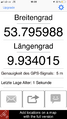
| Wed 7 Aug 2019 in 53,9: 53.7960098, 9.9340089 geohashing.info google osm bing/os kml crox |
Location
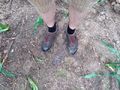
in a field of 3 m high corn in Alveslohe, Schleswig-Holstein
Participants
- Leidenfrost (talk)
- π π π (talk)
Expedition
π π π (log from April 2020)
We cycled about 4 km to this hash from my home. After the first 200 m, we only had to turn a single time, in a less than 30° angle and in the last tenth of the way. Then, only 10 m from the Autobahn 7, we had to walk 30 m through high corn to the hashpoint, where navigating was difficult. We arrived and took photos through the leaves, then biked back.
Photos

proof 1
proof 2
the hash
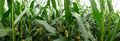
pano 1
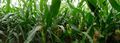
pano 2 (very different)
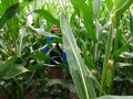
π π π hiding


Achievements
Land geohash, Bicycle geohash