Difference between revisions of "2019-08-10 51 4"
imported>FelixTheCat (Created page with "{{subst:Expedition |lat = 51 |lon = 4 |date = 2019-08-10 }}") |
imported>FelixTheCat |
||
| Line 1: | Line 1: | ||
| − | |||
| − | |||
| − | |||
| − | |||
| − | |||
| − | |||
| − | |||
| − | |||
| − | |||
| − | |||
{{meetup graticule | {{meetup graticule | ||
| lat=51 | | lat=51 | ||
| Line 14: | Line 4: | ||
| date=2019-08-10 | | date=2019-08-10 | ||
}} | }} | ||
| − | |||
| − | |||
__NOTOC__ | __NOTOC__ | ||
| − | |||
== Location == | == Location == | ||
| − | + | On a path next to a field in Bergschenhoek, South Holland province, the Netherlands. | |
== Participants == | == Participants == | ||
| − | + | [[User:FelixTheCat|FelixTheCat]] ([[User talk:FelixTheCat|talk]]) | |
| − | |||
| − | |||
| − | |||
| − | |||
== Expedition == | == Expedition == | ||
| − | + | Today there was finally a hash within a one-hour bike ride from my home. The weather wasn't great, with drizzle in the early morning and rather strong winds. But the rain stopped around the time I had planned to leave, and as it turned out, I had those winds in my back as I rode towards the hash reaching it in about an hour. Once there I took the obligatory pictures, with my phone because somehow my camera's battery had become empty. I then turned around and rode back home, taking about one hour and ten minutes since I now had a strong headwind. This also meant that I was overtaken a few times by senior citizens on electrically-assisted bikes since they obviously have less of a problem with headwinds... | |
| − | |||
| − | |||
| − | |||
== Photos == | == Photos == | ||
| − | |||
| − | |||
| − | |||
<gallery perrow="5"> | <gallery perrow="5"> | ||
| + | Image:2019-08-10 51 4 FelixTheCat 1.JPG | A roundabout in Pijnacker, with an artwork in the centre and typical local architecture behind. | ||
| + | Image:2019-08-10 51 4 FelixTheCat 2.JPG | Near the centre of Bergschenhoek there was a detour due to roadworks. This sign tells you it will take an extra three minutes and burn another 30 kcal. | ||
| + | Image:2019-08-10 51 4 FelixTheCat 3.JPG | "You're almost there" | ||
| + | Image:2019-08-10 51 4 FelixTheCat 4.JPG | Quite near the hash there was this little hill with a watchtower. | ||
| + | Image:2019-08-10 51 4 FelixTheCat 5.JPG | The hash road. About 200 metres to go. | ||
| + | Image:2019-08-10 51 4 FelixTheCat 6.png | Made it. | ||
| + | Image:2019-08-10 51 4 FelixTheCat 7.JPG | Lloyd celebrating. | ||
| + | Image:2019-08-10 51 4 FelixTheCat 8.JPG | My bike at the hash, looking south towards a blue sky. | ||
| + | Image:2019-08-10 51 4 FelixTheCat 9.JPG | Looking north, towards grey clouds. | ||
| + | Image:2019-08-10 51 4 FelixTheCat 10.JPG | A pond next to the road, with lots of water plants and a grey heron looking for fish. | ||
</gallery> | </gallery> | ||
== Achievements == | == Achievements == | ||
{{#vardefine:ribbonwidth|800px}} | {{#vardefine:ribbonwidth|800px}} | ||
| − | + | {{bicycle geohash | |
| − | + | | latitude = 51 | |
| − | + | | longitude = 4 | |
| − | + | | date = 2019-08-10 | |
| − | [[ | + | | name = [[User:FelixTheCat|FelixTheCat]] ([[User talk:FelixTheCat|talk]]) |
| − | + | | distance = 34.2 km | |
| − | + | | bothways = true | |
| − | + | }} | |
| − | |||
| − | |||
| − | [[ | ||
| − | |||
| − | |||
| − | |||
| − | |||
| − | |||
[[Category:Expeditions]] | [[Category:Expeditions]] | ||
| − | |||
[[Category:Expeditions with photos]] | [[Category:Expeditions with photos]] | ||
| − | |||
| − | |||
| − | |||
| − | |||
| − | |||
[[Category:Coordinates reached]] | [[Category:Coordinates reached]] | ||
| − | |||
| − | |||
| − | |||
| − | |||
| − | |||
| − | |||
| − | |||
| − | |||
| − | |||
| − | |||
| − | |||
| − | |||
| − | |||
| − | |||
| − | |||
| − | |||
| − | |||
| − | |||
Revision as of 15:27, 11 August 2019
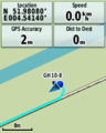
| Sat 10 Aug 2019 in 51,4: 51.9807959, 4.5413984 geohashing.info google osm bing/os kml crox |
Location
On a path next to a field in Bergschenhoek, South Holland province, the Netherlands.
Participants
Expedition
Today there was finally a hash within a one-hour bike ride from my home. The weather wasn't great, with drizzle in the early morning and rather strong winds. But the rain stopped around the time I had planned to leave, and as it turned out, I had those winds in my back as I rode towards the hash reaching it in about an hour. Once there I took the obligatory pictures, with my phone because somehow my camera's battery had become empty. I then turned around and rode back home, taking about one hour and ten minutes since I now had a strong headwind. This also meant that I was overtaken a few times by senior citizens on electrically-assisted bikes since they obviously have less of a problem with headwinds...
Photos
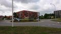
A roundabout in Pijnacker, with an artwork in the centre and typical local architecture behind.
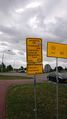
Near the centre of Bergschenhoek there was a detour due to roadworks. This sign tells you it will take an extra three minutes and burn another 30 kcal.
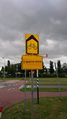
"You're almost there"
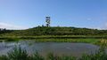
Quite near the hash there was this little hill with a watchtower.
The hash road. About 200 metres to go.
Made it.
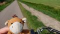
Lloyd celebrating.
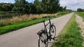
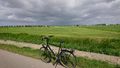
My bike at the hash, looking south towards a blue sky.
Looking north, towards grey clouds.
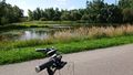
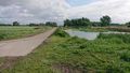
A pond next to the road, with lots of water plants and a grey heron looking for fish.


Achievements
FelixTheCat (talk) earned the Bicycle geohash achievement
|