Difference between revisions of "2019-08-13 51 14"
imported>SuperGrobi (Created page with "{{subst:Expedition |lat = 51 |lon = 14 |date = 2019-08-13 }}") |
SuperGrobi (talk | contribs) (→Photos) |
||
| (5 intermediate revisions by 4 users not shown) | |||
| Line 20: | Line 20: | ||
== Location == | == Location == | ||
<!-- where you've surveyed the hash to be --> | <!-- where you've surveyed the hash to be --> | ||
| + | Close to the Buschmühle, near Stolpen | ||
== Participants == | == Participants == | ||
<!-- who attended: If you link to your wiki user name in this section, your expedition will be picked up by the various statistics generated for geohashing. You may use three tildes ~ as a shortcut to automatically insert the user signature of the account you are editing with. | <!-- who attended: If you link to your wiki user name in this section, your expedition will be picked up by the various statistics generated for geohashing. You may use three tildes ~ as a shortcut to automatically insert the user signature of the account you are editing with. | ||
--> | --> | ||
| + | [[User:SuperGrobi]], [[User:Etodo]] | ||
== Plans == | == Plans == | ||
<!-- what were the original plans --> | <!-- what were the original plans --> | ||
| + | This was our first Geohash. We figured this spot was easy enough to try out | ||
== Expedition == | == Expedition == | ||
<!-- how it all turned out. your narrative goes here. --> | <!-- how it all turned out. your narrative goes here. --> | ||
| − | + | We took the train to Großharthau and then hiked to the location. On our way, we discovered some rather lovely places alongside the stream Wesenitz (right in the spirit of Geohashing). We also met a grumpy local (Still in the spirit of Geohashing, I guess). We found that the location was conveniently placed just on the side of a hiking path. After a bit of back and forth, we decided we were close enough and took our winning photo, including our Stupid Grin®. We also created a temporary proof of our presence. We then continued walking to Stolpen, past a run-down factory, a mysterious metal orb and a house which, if photographed from the right angle and closely cropped, looks like it could be in Tuscany. Because we had a bit of time left in Stolpen before our bus back home would arrive, we took a quick look at the historic town centre, which has three out of the following four things: A water fountain, a monument to basalt, tons of listed buildings, a usable mobile data connection. | |
| − | |||
| − | |||
== Photos == | == Photos == | ||
| Line 39: | Line 40: | ||
--> | --> | ||
<gallery perrow="5"> | <gallery perrow="5"> | ||
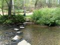
| + | File:2019-08-13 crossingariver.jpg | A stone way across a river, that we did not need to cross. But we did it anyway. Twice. | ||
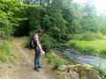
| + | File:2019-08-13 sad.jpg | Being sad, because our friends could not join the expedition. | ||
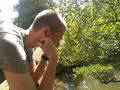
| + | File:2019-08-13 more sad.jpg | More sad. | ||
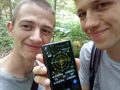
| + | File:2019-08-13 stupidgrin.jpg | No longer sad, as demonstrated by our stupid gins. In the foreground: a smartphone with the coordinates. | ||
| + | File:2019-08-13 bigmetalball.jpg | A curious metal ball we found on the way back home. | ||
| + | File:2019-08-13 basalt.jpg | Some basalt on a market place. Quiet a nice place to look back on the expedition. | ||
</gallery> | </gallery> | ||
| Line 45: | Line 52: | ||
<!-- Add any achievement ribbons you earned below, or remove this section --> | <!-- Add any achievement ribbons you earned below, or remove this section --> | ||
| − | |||
| − | |||
| − | |||
| − | |||
| − | |||
| − | |||
| − | |||
| − | |||
| − | |||
| − | |||
| − | |||
| − | |||
| − | |||
| − | |||
[[Category:Expeditions]] | [[Category:Expeditions]] | ||
| − | |||
| − | |||
| − | |||
| − | |||
| − | |||
| − | |||
| − | |||
[[Category:Coordinates reached]] | [[Category:Coordinates reached]] | ||
| − | + | {{location|DE|SN|SEB}} | |
| − | |||
| − | |||
| − | |||
| − | |||
| − | |||
| − | |||
| − | |||
| − | |||
| − | |||
| − | |||
| − | |||
| − | |||
| − | |||
| − | |||
| − | |||
| − | |||
| − | |||
Latest revision as of 17:24, 26 March 2021
| Tue 13 Aug 2019 in 51,14: 51.0722716, 14.0805321 geohashing.info google osm bing/os kml crox |
Location
Close to the Buschmühle, near Stolpen
Participants
Plans
This was our first Geohash. We figured this spot was easy enough to try out
Expedition
We took the train to Großharthau and then hiked to the location. On our way, we discovered some rather lovely places alongside the stream Wesenitz (right in the spirit of Geohashing). We also met a grumpy local (Still in the spirit of Geohashing, I guess). We found that the location was conveniently placed just on the side of a hiking path. After a bit of back and forth, we decided we were close enough and took our winning photo, including our Stupid Grin®. We also created a temporary proof of our presence. We then continued walking to Stolpen, past a run-down factory, a mysterious metal orb and a house which, if photographed from the right angle and closely cropped, looks like it could be in Tuscany. Because we had a bit of time left in Stolpen before our bus back home would arrive, we took a quick look at the historic town centre, which has three out of the following four things: A water fountain, a monument to basalt, tons of listed buildings, a usable mobile data connection.
Photos
A stone way across a river, that we did not need to cross. But we did it anyway. Twice.
Being sad, because our friends could not join the expedition.
More sad.
No longer sad, as demonstrated by our stupid gins. In the foreground: a smartphone with the coordinates.
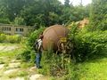
A curious metal ball we found on the way back home.
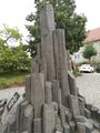
Some basalt on a market place. Quiet a nice place to look back on the expedition.


