Difference between revisions of "2019-08-16 49 8"
From Geohashing
imported>GeorgDerReisende (new report) |
imported>FippeBot m (Location) |
||
| (One intermediate revision by one other user not shown) | |||
| Line 1: | Line 1: | ||
| + | [[Image:{{{image|2019-08-16 49 8 GeorgDerReisende 6482.jpg}}}|thumb|left]] | ||
| − | |||
| − | |||
| − | |||
| − | |||
| − | |||
| − | |||
| − | |||
| − | |||
| − | |||
{{meetup graticule | {{meetup graticule | ||
| lat=49 | | lat=49 | ||
| Line 19: | Line 11: | ||
== Location == | == Location == | ||
| − | + | ||
| + | The hash lay behind a tree at Nierstein-Schwagsburg. | ||
== Participants == | == Participants == | ||
| − | + | ||
| − | + | [[User:GeorgDerReisende|GeorgDerReisende]] | |
== Plans == | == Plans == | ||
| − | + | ||
| + | Traveling and walking. | ||
== Expedition == | == Expedition == | ||
| − | |||
| − | + | There should be a bus between Nierstein and Schwagsburg, but I didn't find its stop. And because I didn't find the stop I had no idea about the timetable and I could have wait for 50 minutes, but instead I walked the whole distance. At the hash I found some fruit which had been burnt by the high ultraviolet radiation. | |
| − | |||
== Photos == | == Photos == | ||
| − | |||
| − | |||
| − | |||
<gallery perrow="5"> | <gallery perrow="5"> | ||
| + | 2019-08-16 49 8 GeorgDerReisende 6216.jpg | arrived in Nierstein | ||
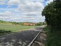
| + | 2019-08-16 49 8 GeorgDerReisende 6469.jpg | the road to hash | ||
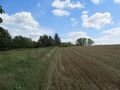
| + | 2019-08-16 49 8 GeorgDerReisende 6470.jpg | counting fields - the first | ||
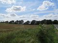
| + | 2019-08-16 49 8 GeorgDerReisende 6471.jpg | counting fields - the second with the tree | ||
| + | 2019-08-16 49 8 GeorgDerReisende 6472.jpg | counting fields - the third one | ||
| + | 2019-08-16 49 8 GeorgDerReisende 6473.jpg | location of hash - from the other side | ||
| + | 2019-08-16 49 8 GeorgDerReisende 6474.jpg | beyond the tree | ||
| + | 2019-08-16 49 8 GeorgDerReisende 6475.jpg | looking north | ||
| + | 2019-08-16 49 8 GeorgDerReisende 6476.jpg | looking east | ||
| + | 2019-08-16 49 8 GeorgDerReisende 6477.jpg | looking west | ||
| + | 2019-08-16 49 8 GeorgDerReisende 6478.jpg | looking south | ||
| + | 2019-08-16 49 8 GeorgDerReisende 6482.jpg | found: unknown fruit, burnt by the high ultraviolet radiation | ||
</gallery> | </gallery> | ||
| − | + | [[Category:Expeditions]] | |
| − | |||
| − | |||
| − | + | [[Category:Expeditions with photos]] | |
| − | |||
| − | [[Category: | ||
| − | + | [[Category:Expedition without GPS]] | |
| − | |||
| − | |||
| − | |||
| − | [[Category:Expedition | ||
| − | |||
| − | |||
| − | |||
| − | |||
| − | |||
| − | |||
| − | |||
| − | |||
| − | |||
| − | |||
| − | |||
| − | |||
[[Category:Coordinates reached]] | [[Category:Coordinates reached]] | ||
| − | + | {{location|DE|RP|MZ}} | |
| − | |||
| − | |||
| − | |||
| − | |||
| − | |||
| − | |||
| − | |||
| − | |||
| − | |||
| − | |||
| − | |||
| − | |||
| − | |||
| − | |||
| − | |||
| − | |||
| − | |||
Latest revision as of 20:42, 22 August 2019

| Fri 16 Aug 2019 in 49,8: 49.8623145, 8.3013722 geohashing.info google osm bing/os kml crox |
Location
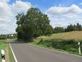
The hash lay behind a tree at Nierstein-Schwagsburg.
Participants
Plans
Traveling and walking.
Expedition
There should be a bus between Nierstein and Schwagsburg, but I didn't find its stop. And because I didn't find the stop I had no idea about the timetable and I could have wait for 50 minutes, but instead I walked the whole distance. At the hash I found some fruit which had been burnt by the high ultraviolet radiation.
Photos
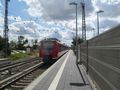
arrived in Nierstein
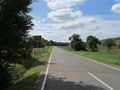
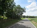
the road to hash
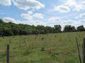
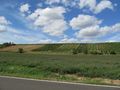
counting fields - the first
counting fields - the second with the tree
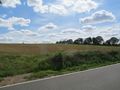
counting fields - the third one
location of hash - from the other side
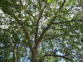
beyond the tree
looking north
looking east
looking west
looking south
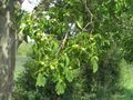
found: unknown fruit, burnt by the high ultraviolet radiation


